Enable Location

We need your location to show you interesting places around you

Discover nearby places

Find interesting locations and hidden gems around you

Precise directions

Get accurate directions and distances to places

Your location is never shared with other users. It's only used when you tap the location button.

Reynolds Bridge

Log in to your account

Start exploring — it's free

Trusted by 62,490 travelers worldwide

Continue with Google
Continue with Apple
or

We will send you a code to connect

By continuing, you accept our Terms and Conditions and our Privacy Policy

Check your inbox

We've sent a pincode in your inbox. Please enter the code below.

Reynolds Bridge, bridge in United States of America

Reynolds Bridge is a concrete arch bridge built in 1928 in Thomaston, Connecticut, spanning the Naugatuck River. It features three open-spandrel arches with the main span reaching 169 feet, and it was added to the National Register of Historic Places in 2004.

Construction started in 1925 after the state Department of Transportation decided to improve travel routes. The old crossing was narrow and flood-prone, so the new bridge was raised higher to prevent flooding and handle more traffic safely.

The bridge was named after the original landowner in the area. Today, residents and visitors use it as a key crossing, and many stop to observe the sturdy arches and the craftsmanship visible in its structure.

The bridge is located in Thomaston, roughly midway between Waterbury and downtown, near Exit 38 on Connecticut Route 8. It has sidewalks on both sides for pedestrians to walk across safely.

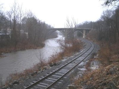
The river is crossed not only by road but also above an active railroad and a former streetcar line, both running beneath the structure. This makes it one of the rare bridges that simultaneously carries three different transportation routes.

The community of curious travelers

AroundUs brings together thousands of curated places, local tips, and hidden gems, enriched daily by 60,000 contributors worldwide.

Start exploring
Location
GPS coordinates
41.65310,-73.07690
Latest update
February 9, 2026 07:40
Around this place
United States of America

Muzzy Field

10 km
Bellamy-Ferriday House and Garden
United States of America

Bellamy-Ferriday House and Garden

11 km
Black Rock State Park
United States of America

Black Rock State Park

2.5 km
Garbage Museum
United States of America

Garbage Museum

7.3 km
Jericho Trail
United States of America

Jericho Trail

3.1 km
Hancock Brook Trail
United States of America

Hancock Brook Trail

5.9 km
Mattatuck State Forest
United States of America

Mattatuck State Forest

1.5 km
Thomaston Opera House
United States of America

Thomaston Opera House

2.2 km
United States of America

Lock Museum of America

6.2 km
Humaston Brook State Park
United States of America

Humaston Brook State Park

6.1 km
Benedict-Miller House
United States of America

Benedict-Miller House

10.6 km
Beth El Synagogue
United States of America

Beth El Synagogue

10 km
Trinity Church
United States of America

Trinity Church

2.2 km
East Plymouth Historic District
United States of America

East Plymouth Historic District

7.9 km
George S. Abbott Building
United States of America

George S. Abbott Building

11 km
Sheffield Street Bridge
United States of America

Sheffield Street Bridge

6.7 km
Overlook Historic District
United States of America

Overlook Historic District

9.8 km
Roderick Bryan House
United States of America

Roderick Bryan House

4.7 km
Bristol Girls' Club
United States of America

Bristol Girls' Club

10.9 km
Terryville Waterwheel
United States of America

Terryville Waterwheel

5.9 km
Clara T. O'Connell School
United States of America

Clara T. O'Connell School

10.4 km
Skilton Road Bridge
United States of America

Skilton Road Bridge

7.3 km
Wolcott Green Historic District
United States of America

Wolcott Green Historic District

10.2 km
Endee Manor Historic District
United States of America

Endee Manor Historic District

10.3 km
Watertown Center Historic District
United States of America

Watertown Center Historic District

6.5 km
Town Hall and District School No. 6
United States of America

Town Hall and District School No. 6

10.7 km
Train Station
United States of America

Train Station

2.4 km
American Italian Civic Club Park
United States of America

American Italian Civic Club Park

7.7 km
Show the full map
« Reynolds Bridge - bridge in United States of America » is provided by Around Us (aroundus.com). Images and texts are derived from Wikimedia project under a Creative Commons license. You are allowed to copy, distribute, and modify copies of this page, under the conditions set by the license, as long as this note is clearly visible.

Discover hidden gems everywhere you go!

From secret cafés to breathtaking viewpoints, skip the crowded tourist spots and find places that match your style. Our app makes it easy with voice search, smart filtering, route optimization, and insider tips from travelers worldwide. Download now for the complete mobile experience.

Around Us App Screenshot

A unique approach to discovering new places

Le Figaro

All the places worth exploring

France Info

A tailor-made excursion in just a few clicks

20 Minutes

Around Us
Travel Guide & Maps
Download

Send to your phone

QR Code
1

Open the camera app on your mobile.

2

Point at the QR code with your camera. A notification will appear.

3

Tap the notification to open the link.