Enable Location

We need your location to show you interesting places around you

Discover nearby places

Find interesting locations and hidden gems around you

Precise directions

Get accurate directions and distances to places

Your location is never shared with other users. It's only used when you tap the location button.

Black Rock State Park

Log in to your account

Start exploring — it's free

Trusted by 62,977 travelers worldwide

Continue with Google
Continue with Apple
or

We will send you a code to connect

By continuing, you accept our Terms and Conditions and our Privacy Policy

Check your inbox

We've sent a pincode in your inbox. Please enter the code below.

Black Rock State Park
Discussion Reviews 1 Photos 1 Collections
4.2k Popularity

Black Rock State Park, State park in Watertown, Connecticut, United States.

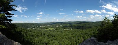
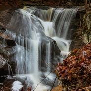
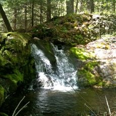
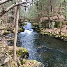
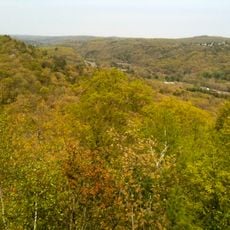
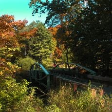
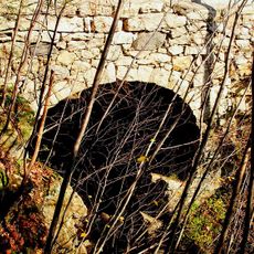
Black Rock State Park is a woodland park in Watertown featuring forested hills, lakes, and streams spread across the landscape. The terrain includes trails that wind through dense woods and along water features throughout the property.

The park was established in the 1920s through a land donation and was further developed during the 1930s by work crews. This development reflected broader conservation efforts happening in that era.

Native American tribes including Mohegan, Paugussett, and Tunxis left their mark through artifacts such as arrowheads and stone tools found throughout the park.

The park provides tent sites and simple cabins for overnight stays along with picnic areas and fire rings. Visitors should expect uneven, wooded terrain and plan accordingly for the seasonal availability of overnight facilities.

The park is named after graphite deposits that early residents called black rock and mined for the mineral. This historical mining activity shaped the place's name long before the park was established.

The community of curious travelers

AroundUs brings together thousands of curated places, local tips, and hidden gems, enriched daily by 60,000 contributors worldwide.

Start exploring
Location
Inception
1926
Elevation above the sea
167 m
GPS coordinates
41.65512,-73.10643
Latest update
December 6, 2025 17:42
Nature sites and historic places in Connecticut

Connecticut combines different landscapes from the coast to the mountains with a range of historic sites. The region includes state parks with waterfalls like Kent Falls and Wadsworth Falls, extensive forested areas, and conservation lands. Visitors can hike through White Memorial Conservation...

Around this place
Bellamy-Ferriday House and Garden
United States of America

Bellamy-Ferriday House and Garden

8.6 km
Garbage Museum
United States of America

Garbage Museum

5.1 km
Topsmead
United States of America

Topsmead

11.1 km
Jericho Trail
United States of America

Jericho Trail

5.1 km
White Memorial Foundation
United States of America

White Memorial Foundation

11.7 km
Hancock Brook Trail
United States of America

Hancock Brook Trail

7.3 km
Mattatuck State Forest
United States of America

Mattatuck State Forest

1.7 km
Thomaston Opera House
United States of America

Thomaston Opera House

3.3 km
United States of America

Lock Museum of America

8.4 km
Humaston Brook State Park
United States of America

Humaston Brook State Park

5.3 km
Christ Episcopal Church
United States of America

Christ Episcopal Church

8.7 km
Benedict-Miller House
United States of America

Benedict-Miller House

11.7 km
Beth El Synagogue
United States of America

Beth El Synagogue

11.2 km
Trinity Church
United States of America

Trinity Church

3.2 km
Reynolds Bridge
United States of America

Reynolds Bridge

2.5 km
East Plymouth Historic District
United States of America

East Plymouth Historic District

10 km
Bethlehem Green Historic District
United States of America

Bethlehem Green Historic District

8.7 km
Sheffield Street Bridge
United States of America

Sheffield Street Bridge

8.1 km
Overlook Historic District
United States of America

Overlook Historic District

10.8 km
Roderick Bryan House
United States of America

Roderick Bryan House

2.4 km
Terryville Waterwheel
United States of America

Terryville Waterwheel

8.1 km
Minortown Road Bridge
United States of America

Minortown Road Bridge

10.5 km
Skilton Road Bridge
United States of America

Skilton Road Bridge

5.3 km
Caleb Martin House
United States of America

Caleb Martin House

10 km
Watertown Center Historic District
United States of America

Watertown Center Historic District

5.8 km
Town Hall and District School No. 6
United States of America

Town Hall and District School No. 6

8.3 km
Train Station
United States of America

Train Station

3.8 km
American Italian Civic Club Park
United States of America

American Italian Civic Club Park

9.2 km
Show the full map
Reviews
Share your experience

No review yet

Discussions
Start a discussion...

No discussion yet

« Black Rock State Park - State park in Watertown, Connecticut, United States » is provided by Around Us (aroundus.com). Images and texts are derived from Wikimedia project under a Creative Commons license. You are allowed to copy, distribute, and modify copies of this page, under the conditions set by the license, as long as this note is clearly visible.

Discover hidden gems everywhere you go!

From secret cafés to breathtaking viewpoints, skip the crowded tourist spots and find places that match your style. Our app makes it easy with voice search, smart filtering, route optimization, and insider tips from travelers worldwide. Download now for the complete mobile experience.

Around Us App Screenshot

A unique approach to discovering new places

Le Figaro

All the places worth exploring

France Info

A tailor-made excursion in just a few clicks

20 Minutes

Around Us
Travel Guide & Maps
Download

Send to your phone

QR Code
1

Open the camera app on your mobile.

2

Point at the QR code with your camera. A notification will appear.

3

Tap the notification to open the link.