Enable Location

We need your location to show you interesting places around you

Discover nearby places

Find interesting locations and hidden gems around you

Precise directions

Get accurate directions and distances to places

Your location is never shared with other users. It's only used when you tap the location button.

Rondout Reservoir

Log in to your account

Start exploring — it's free

Trusted by 62,989 travelers worldwide

Continue with Google
Continue with Apple
or

We will send you a code to connect

By continuing, you accept our Terms and Conditions and our Privacy Policy

Check your inbox

We've sent a pincode in your inbox. Please enter the code below.

Rondout Reservoir
Discussion Reviews 1 Photos
10.4k Popularity

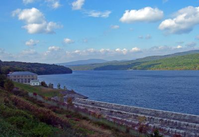
Rondout Reservoir, Water reservoir in Catskill Mountains, United States

Rondout Reservoir is a large body of water in the Catskill Mountains, created by damming Rondout Creek to form a long lake winding through forested hills. The water surface reflects the surrounding landscape, with dense woods covering the banks and mountains visible in the distance.

The reservoir was created in the mid-20th century by damming Rondout Creek and has served since then as a major water source for the region. Its construction reshaped the local landscape and became part of a larger water management system.

The reservoir forms part of New York City's Delaware System, providing essential water resources to millions of residents in the metropolitan area.

The reservoir offers access for fishing and water activities from several points along its shoreline, with parking areas available at main entry spots. Visitors should check local regulations before planning water-based activities.

The reservoir receives water from multiple other storage lakes through an underground tunnel network that gathers resources from different mountain streams. This hidden engineering system works unseen, connecting distant water sources into a single supply network.

The community of curious travelers

AroundUs brings together thousands of curated places, local tips, and hidden gems, enriched daily by 60,000 contributors worldwide.

Start exploring
Location
GPS coordinates
41.82260,-74.47100
Latest update
December 8, 2025 19:52
Around this place
Stagedoor Manor
United States of America

Stagedoor Manor

16.5 km
Stony Kill Falls
United States of America

Stony Kill Falls

17.6 km
Neversink Reservoir
United States of America

Neversink Reservoir

13.9 km
Verkeerder Kill Falls
United States of America

Verkeerder Kill Falls

19.4 km
Peekamoose Mountain
United States of America

Peekamoose Mountain

15.7 km
Red Hill Fire Observation Station
United States of America

Red Hill Fire Observation Station

11.9 km
Table Mountain
United States of America

Table Mountain

16.1 km
B'nai Israel Synagogue
United States of America

B'nai Israel Synagogue

13 km
South Fallsburg Hebrew Association Synagogue
United States of America

South Fallsburg Hebrew Association Synagogue

18.5 km
Hebrew Congregation of Mountaindale Synagogue
United States of America

Hebrew Congregation of Mountaindale Synagogue

15.7 km
Halls Mills Bridge
United States of America

Halls Mills Bridge

12.4 km
Loch Sheldrake Synagogue
United States of America

Loch Sheldrake Synagogue

16.6 km
Ohave Shalom Synagogue
United States of America

Ohave Shalom Synagogue

15 km
Grahamsville Historic District
United States of America

Grahamsville Historic District

6.2 km
Cragsmoor Historic District
United States of America

Cragsmoor Historic District

18.7 km
Ulster Heights Synagogue
United States of America

Ulster Heights Synagogue

6.1 km
Center Theatre
United States of America

Center Theatre

13 km
Ellenville Downtown Historic District
United States of America

Ellenville Downtown Historic District

13.4 km
Congregation Tifereth Yehuda Veyisroel
United States of America

Congregation Tifereth Yehuda Veyisroel

15.5 km
Hoornbeek Store Complex
United States of America

Hoornbeek Store Complex

12.1 km
Sebastian Baker Stone House
United States of America

Sebastian Baker Stone House

18.8 km
Terwilliger-Smith Farm
United States of America

Terwilliger-Smith Farm

12.9 km
Woodbourne Reformed Church Complex
United States of America

Woodbourne Reformed Church Complex

12.7 km
J. Dupuy Stone House
United States of America

J. Dupuy Stone House

16.1 km
C. K. Schoonmaker Stone House
United States of America

C. K. Schoonmaker Stone House

16.8 km
Zachariah Barley Stone House
United States of America

Zachariah Barley Stone House

19.2 km
Schoonmaker Stone House and Farm
United States of America

Schoonmaker Stone House and Farm

13.5 km
Jacob Hoornbeck Stone House
United States of America

Jacob Hoornbeck Stone House

15.2 km
Show the full map
Reviews
Share your experience

No review yet

Discussions
Start a discussion...

No discussion yet

« Rondout Reservoir - Water reservoir in Catskill Mountains, United States » is provided by Around Us (aroundus.com). Images and texts are derived from Wikimedia project under a Creative Commons license. You are allowed to copy, distribute, and modify copies of this page, under the conditions set by the license, as long as this note is clearly visible.

Discover hidden gems everywhere you go!

From secret cafés to breathtaking viewpoints, skip the crowded tourist spots and find places that match your style. Our app makes it easy with voice search, smart filtering, route optimization, and insider tips from travelers worldwide. Download now for the complete mobile experience.

Around Us App Screenshot

A unique approach to discovering new places

Le Figaro

All the places worth exploring

France Info

A tailor-made excursion in just a few clicks

20 Minutes

Around Us
Travel Guide & Maps
Download

Send to your phone

QR Code
1

Open the camera app on your mobile.

2

Point at the QR code with your camera. A notification will appear.

3

Tap the notification to open the link.