Halls Mills Bridge

Log in to your account

AroundUs is a community-driven map of interesting places, built by curious explorers like you. It grows with every review, story, and photo you share.
Connect to save your favorite spots, contribute locations, and create personalized routes.
Continue with Google
Continue with Apple
Continue with X
Continue with Facebook
Continue with email
By continuing, you accept our Terms and Conditions and our Privacy Policy
Create an account
Add to collection
Map
Suggest a change
Share

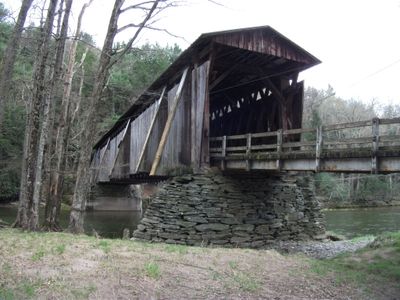
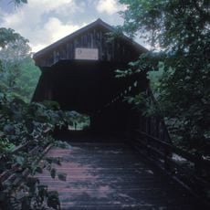
Halls Mills Bridge, Covered bridge in Claryville, New York, US

Halls Mills Bridge is a covered wooden bridge spanning the Neversink River in Claryville with a lattice truss design and six buttresses on each side. The structure rests on dry stacked stone abutments built directly into the riverbanks.

The structure was completed in 1912 by builders David Benton and James Knight, replacing an earlier bridge destroyed by flooding. This reconstruction was necessary to restore the crossing over the river in this rural region.

The bridge reflects the heritage of early settlers in the Upper Neversink Valley, guided by John Hall, a Quaker preacher. Today, visitors can sense this connection to the past while walking across the wooden structure.

Visitors can reach this bridge by following Hunter Road Spur Number 39A, with parking available about 200 meters from the structure. The walk is short and leads to a quiet riverside spot, good for a quick visit or photographs.

This bridge is one of only four remaining covered bridges in Sullivan County and showcases a rare lattice truss design that sets it apart from newer structures. The combination of historic craftsmanship and its natural setting makes it a notable example of early 20th-century rural infrastructure.

Location: New York

GPS coordinates: 41.89010,-74.58990

Latest update: December 14, 2025 17:03

Photos
Around this place
Stagedoor Manor
United States of America

Stagedoor Manor

14.5 km
Slide Mountain
United States of America

Slide Mountain

20.8 km
Rondout Reservoir
United States of America

Rondout Reservoir

12.4 km
Neversink Reservoir
United States of America

Neversink Reservoir

8.2 km
Dai Bosatsu Zendo Kongo-ji
United States of America

Dai Bosatsu Zendo Kongo-ji

16 km
Peekamoose Mountain
United States of America

Peekamoose Mountain

17.4 km
Balsam Lake Mountain Fire Observation Station
United States of America

Balsam Lake Mountain Fire Observation Station

17.3 km
Balsam Lake Mountain
United States of America

Balsam Lake Mountain

17.3 km
Graham Mountain
United States of America

Graham Mountain

16.9 km
Red Hill Fire Observation Station
United States of America

Red Hill Fire Observation Station

7.1 km
Table Mountain
United States of America

Table Mountain

17.1 km
B'nai Israel Synagogue
United States of America

B'nai Israel Synagogue

14.7 km
South Fallsburg Hebrew Association Synagogue
United States of America

South Fallsburg Hebrew Association Synagogue

20.7 km
Agudas Achim Synagogue
United States of America

Agudas Achim Synagogue

19.5 km
Loch Sheldrake Synagogue
United States of America

Loch Sheldrake Synagogue

14.4 km
Tefereth Israel Anshei Parksville Synagogue
United States of America

Tefereth Israel Anshei Parksville Synagogue

14.8 km
Ohave Shalom Synagogue
United States of America

Ohave Shalom Synagogue

20 km
Eagle Mountain
United States of America

Eagle Mountain

20.3 km
Grahamsville Historic District
United States of America

Grahamsville Historic District

6.4 km
Ulster Heights Synagogue
United States of America

Ulster Heights Synagogue

13.6 km
Center Theatre
United States of America

Center Theatre

14.7 km
Tappan Bridge
United States of America

Tappan Bridge

20.2 km
Van Tran Flat Bridge
United States of America

Van Tran Flat Bridge

20.2 km
Bendo Bridge
United States of America

Bendo Bridge

9.3 km
Woodbourne Reformed Church Complex
United States of America

Woodbourne Reformed Church Complex

14.3 km
First Methodist Episcopal Church of Parksville
United States of America

First Methodist Episcopal Church of Parksville

14.5 km
Sullivan County Museum
United States of America

Sullivan County Museum

18.1 km
Liberty Downtown Historic District
United States of America

Liberty Downtown Historic District

16.4 km
Show the full map
Reviews

Visited this place? Tap the stars to rate it and share your experience / photos with the community! Try now! You can cancel it anytime.

« Halls Mills Bridge - Covered bridge in Claryville, New York, US » is provided by Around Us (aroundus.com). Images and texts are derived from Wikimedia project under a Creative Commons license. You are allowed to copy, distribute, and modify copies of this page, under the conditions set by the license, as long as this note is clearly visible.

Discover hidden gems everywhere you go!

From secret cafés to breathtaking viewpoints, skip the crowded tourist spots and find places that match your style. Our app makes it easy with voice search, smart filtering, route optimization, and insider tips from travelers worldwide. Download now for the complete mobile experience.

Around Us App Screenshot

A unique approach to discovering new places

Le Figaro

All the places worth exploring

France Info

A tailor-made excursion in just a few clicks

20 Minutes