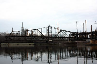
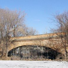
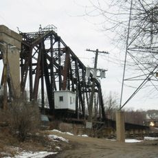
Rock Island Swing Bridge, Railway and toll bridge across Mississippi River in Inver Grove Heights and St. Paul Park, US
Rock Island Swing Bridge is a railway and toll crossing that spans the Mississippi River between Inver Grove Heights and St. Paul Park with a double-deck structure. The upper level carried train traffic while the lower deck accommodated vehicle passage across the river.
Pittsburgh Bridge Company built this structure in 1895 to link stockyards in South St. Paul with main rail lines in the area. The crossing remained operational until structural issues forced its permanent closure in 1999.
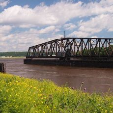
The bridge gained notoriety when John Dillinger reportedly used it as an escape route during his encounters with law enforcement in the 1930s.
The bridge required operators to coordinate train schedules with vehicle traffic and riverboat passages due to its swing mechanism. Today the structure remains closed to public use and is viewable only from a distance.
Horses powered the manual swing mechanism until the 1950s, with a 400-foot section rotating to allow river traffic through. This unusual method remained in daily use long after mechanical alternatives became available elsewhere.
Location: Inver Grove Heights
Location: St. Paul Park
Official opening: 1895
GPS coordinates: 44.85330,-93.00890
Latest update: December 12, 2025 07:52
Indian Mounds Park
10.9 km
Smith Avenue High Bridge
11.7 km
El Burrito Mercado
10.1 km
Wakota Bridge
3.4 km
Stockyards Exchange
4.6 km
St. Paul Union Pacific Rail Bridge
8 km
Cordenio Severance House
8.2 km
St. Stefan's Romanian Orthodox Church
5.3 km
Serbian Home
4.2 km
Riverside Hangar
10.7 km
Reuben Freeman House
4.1 km
Colorado Street Bridge
10.8 km
Riverview Branch Library
10.4 km
George W. Wentworth House
7.1 km
Saint Matthew's School
10.5 km
John P. Furber House
10.1 km
Anthony Yoerg, Sr. House
11.2 km
Rau/Strong House
10.4 km
Giesen–Hauser House
11.6 kmDwight and Clara Watson House
10.8 km
Edward and Elizabeth Heimbach House and Carriage House
10.9 km
Park Grove Bowl
3 km
Cottage Grove Spalsh Pad
5.5 km
Battle Creek Waterworks
10.1 km
Omaha Road Bridge Number 15
11.6 km
Mendota Road Bridge
11.4 km
Sun Ray Branch Library
11.2 km
South Saint Paul Public Library
4.7 kmVisited this place? Tap the stars to rate it and share your experience / photos with the community! Try now! You can cancel it anytime.
Discover hidden gems everywhere you go!
From secret cafés to breathtaking viewpoints, skip the crowded tourist spots and find places that match your style. Our app makes it easy with voice search, smart filtering, route optimization, and insider tips from travelers worldwide. Download now for the complete mobile experience.
A unique approach to discovering new places❞
— Le Figaro
All the places worth exploring❞
— France Info
A tailor-made excursion in just a few clicks❞
— 20 Minutes