Enable Location

We need your location to show you interesting places around you

Discover nearby places

Find interesting locations and hidden gems around you

Precise directions

Get accurate directions and distances to places

Your location is never shared with other users. It's only used when you tap the location button.

Riverside Hangar

Log in to your account

Start exploring — it's free

Trusted by 62,461 travelers worldwide

Continue with Google
Continue with Apple
or

We will send you a code to connect

By continuing, you accept our Terms and Conditions and our Privacy Policy

Check your inbox

We've sent a pincode in your inbox. Please enter the code below.

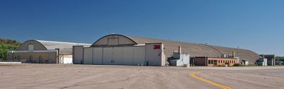
Riverside Hangar, Military hangar at St. Paul Downtown Airport, United States.

Riverside Hangar is an aircraft shelter at St. Paul Downtown Airport consisting of two parallel structures connected by wooden framework spanning a long, open interior space. The facility was designed specifically for aircraft modification and maintenance work.

This hangar was built in 1942 during World War II as a modification center for B-24 Liberator bombers used in military operations. The structure remained at the airport long after the war and eventually gained recognition for its engineering innovations.

The building shows how wartime constraints led to creative engineering solutions that became a defining feature of the structure. The laminated wood arches that make up the interior are still visible today and stand as a reminder of that resourceful approach.

This hangar is located on the grounds of St. Paul Downtown Airport across the Mississippi River from downtown. Visitors should be prepared for an industrial setting with open areas, so comfortable shoes and weather protection are recommended.

The hangar received recognition on the National Register of Historic Places in 2007, relatively late for a structure built in the 1940s. This delayed recognition reflects how industrial wartime buildings were often overlooked before their historical value was finally appreciated.

The community of curious travelers

AroundUs brings together thousands of curated places, local tips, and hidden gems, enriched daily by 60,000 contributors worldwide.

Start exploring
Location
GPS coordinates
44.94167,-93.06194
Latest update
December 14, 2025 17:40
Around this place
Indian Mounds Park
United States of America

Indian Mounds Park

790 m
Lowertown Historic District
United States of America

Lowertown Historic District

2.1 km
First National Bank Building
United States of America

First National Bank Building

2.4 km
Pioneer and Endicott Buildings
United States of America

Pioneer and Endicott Buildings

2.3 km
Cray Plaza
United States of America

Cray Plaza

2.1 km
Raspberry Island
United States of America

Raspberry Island

2.3 km
Robert Street Bridge
United States of America

Robert Street Bridge

2 km
Wabasha Street Bridge
United States of America

Wabasha Street Bridge

2.3 km
Lafayette Bridge
United States of America

Lafayette Bridge

1.5 km
Seventh Street Improvement Arches
United States of America

Seventh Street Improvement Arches

2 km
Bruce Vento Nature Sanctuary
United States of America

Bruce Vento Nature Sanctuary

1.3 km
St. Paul Union Pacific Vertical-lift Rail Bridge
United States of America

St. Paul Union Pacific Vertical-lift Rail Bridge

2.1 km
Colorado Street Bridge
United States of America

Colorado Street Bridge

1.9 km
Riverview Branch Library
United States of America

Riverview Branch Library

2.2 km
Saint Matthew's School
United States of America

Saint Matthew's School

2.2 km
Commerce Building
United States of America

Commerce Building

2.5 km
Benjamin Brunson House
United States of America

Benjamin Brunson House

2.3 km
Adolf Muench House
United States of America

Adolf Muench House

1.8 km
Manhattan Building
United States of America

Manhattan Building

2.3 km
Finch, Vanslyck, and McConville Dry Goods Company Building
United States of America

Finch, Vanslyck, and McConville Dry Goods Company Building

2.2 km
Euclid View Flats
United States of America

Euclid View Flats

1.4 km
Rau/Strong House
United States of America

Rau/Strong House

2.3 km
Giesen–Hauser House
United States of America

Giesen–Hauser House

1 km
United States of America

Dwight and Clara Watson House

2.1 km
Edward and Elizabeth Heimbach House and Carriage House
United States of America

Edward and Elizabeth Heimbach House and Carriage House

2.2 km
Minnesota Building
United States of America

Minnesota Building

2.4 km
Degree of Honor Protective Association Building
United States of America

Degree of Honor Protective Association Building

2.4 km
Indian Mounds Park Mound Group
United States of America

Indian Mounds Park Mound Group

623 m
Show the full map
« Riverside Hangar - Military hangar at St. Paul Downtown Airport, United States » is provided by Around Us (aroundus.com). Images and texts are derived from Wikimedia project under a Creative Commons license. You are allowed to copy, distribute, and modify copies of this page, under the conditions set by the license, as long as this note is clearly visible.

Discover hidden gems everywhere you go!

From secret cafés to breathtaking viewpoints, skip the crowded tourist spots and find places that match your style. Our app makes it easy with voice search, smart filtering, route optimization, and insider tips from travelers worldwide. Download now for the complete mobile experience.

Around Us App Screenshot

A unique approach to discovering new places

Le Figaro

All the places worth exploring

France Info

A tailor-made excursion in just a few clicks

20 Minutes

Around Us
Travel Guide & Maps
Download

Send to your phone

QR Code
1

Open the camera app on your mobile.

2

Point at the QR code with your camera. A notification will appear.

3

Tap the notification to open the link.