Enable Location

We need your location to show you interesting places around you

Discover nearby places

Find interesting locations and hidden gems around you

Precise directions

Get accurate directions and distances to places

Your location is never shared with other users. It's only used when you tap the location button.

Lafayette Bridge

Log in to your account

Start exploring — it's free

Trusted by 61,555 travelers worldwide

Continue with Google
Continue with Apple
or

We will send you a code to connect

By continuing, you accept our Terms and Conditions and our Privacy Policy

Check your inbox

We've sent a pincode in your inbox. Please enter the code below.

Lafayette Bridge

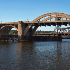
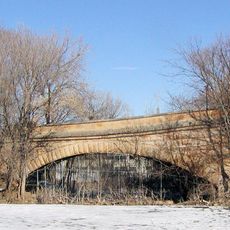
Lafayette Bridge, Highway bridge in Saint Paul, US.

Description

The Lafayette Bridge is a modern highway crossing over the Mississippi River in Saint Paul that carries traffic on Minnesota 52 with two separate directional roadways. The structure provides multiple lanes for vehicles and dedicated paths for cyclists and pedestrians on either side.

History

The current bridge was built from 2011 to 2015 and replaced the original 1968 structure that faced serious safety concerns. The new design was necessary to meet modern traffic demands and provide safe conditions.

Culture

The bridge design incorporates artistic elements in its railings and pier columns, reflecting the architectural heritage of Saint Paul's riverside community.

Practical

The bridge handles thousands of vehicles daily, so drivers should expect busy conditions during rush hours. Cyclists and pedestrians use separate paths that are passable throughout the day.

Did you know?

Engineers integrated local materials and environmental considerations into the bridge construction to minimize impact on the Mississippi River ecosystem.

Location
Inception
2015
Official opening
2015
GPS coordinates
44.94670,-93.07920
Latest update
December 12, 2025 17:43

AroundUs brings together thousands of curated places, local tips, and hidden gems, enriched daily by 60,000 contributors worldwide. Discover all places nearby (Saint Paul).

Around this place
Wells Fargo Place
United States of America

Wells Fargo Place

1.3 km
Lowertown Historic District
United States of America

Lowertown Historic District

669 m
First National Bank Building
United States of America

First National Bank Building

935 m
Pioneer and Endicott Buildings
United States of America

Pioneer and Endicott Buildings

851 m
Cray Plaza
United States of America

Cray Plaza

663 m
Raspberry Island
United States of America

Raspberry Island

1 km
Saint Paul City Hall and Ramsey County Courthouse
United States of America

Saint Paul City Hall and Ramsey County Courthouse

1.2 km
Robert Street Bridge
United States of America

Robert Street Bridge

717 m
Vision of Peace
United States of America

Vision of Peace

1.2 km
Wabasha Street Bridge
United States of America

Wabasha Street Bridge

1.1 km
Seventh Street Improvement Arches
United States of America

Seventh Street Improvement Arches

1.1 km
Bruce Vento Nature Sanctuary
United States of America

Bruce Vento Nature Sanctuary

768 m
St. Paul Union Pacific Vertical-lift Rail Bridge
United States of America

St. Paul Union Pacific Vertical-lift Rail Bridge

769 m
United States of America

Town Square

1.2 km
Saint Paul Women's City Club
United States of America

Saint Paul Women's City Club

1.2 km
The Pointe of St. Paul
United States of America

The Pointe of St. Paul

1.4 km
Colorado Street Bridge
United States of America

Colorado Street Bridge

1.4 km
Germania Bank Building
United States of America

Germania Bank Building

1.2 km
Commerce Building
United States of America

Commerce Building

1.1 km
Amhoist Tower
United States of America

Amhoist Tower

1.3 km
Benjamin Brunson House
United States of America

Benjamin Brunson House

1.2 km
Adolf Muench House
United States of America

Adolf Muench House

1.1 km
Manhattan Building
United States of America

Manhattan Building

887 m
Finch, Vanslyck, and McConville Dry Goods Company Building
United States of America

Finch, Vanslyck, and McConville Dry Goods Company Building

697 m
Euclid View Flats
United States of America

Euclid View Flats

1.3 km
Minnesota Building
United States of America

Minnesota Building

1 km
Park Square Theatre
United States of America

Park Square Theatre

1.3 km
Degree of Honor Protective Association Building
United States of America

Degree of Honor Protective Association Building

1.1 km
Show the full map
« Lafayette Bridge - Highway bridge in Saint Paul, US » is provided by Around Us (aroundus.com). Images and texts are derived from Wikimedia project under a Creative Commons license. You are allowed to copy, distribute, and modify copies of this page, under the conditions set by the license, as long as this note is clearly visible.

Discover hidden gems everywhere you go!

From secret cafés to breathtaking viewpoints, skip the crowded tourist spots and find places that match your style. Our app makes it easy with voice search, smart filtering, route optimization, and insider tips from travelers worldwide. Download now for the complete mobile experience.

Around Us App Screenshot

A unique approach to discovering new places

Le Figaro

All the places worth exploring

France Info

A tailor-made excursion in just a few clicks

20 Minutes

Around Us
Travel Guide & Maps
Download

Send to your phone

QR Code
1

Open the camera app on your mobile.

2

Point at the QR code with your camera. A notification will appear.

3

Tap the notification to open the link.