Enable Location

We need your location to show you interesting places around you

Discover nearby places

Find interesting locations and hidden gems around you

Precise directions

Get accurate directions and distances to places

Your location is never shared with other users. It's only used when you tap the location button.

Route 128 station

Log in to your account

Start exploring — it's free

Trusted by 68,301 travelers worldwide

Continue with Google
Continue with Apple
or

We will send you a code to connect

By continuing, you accept our Terms and Conditions and our Privacy Policy

Check your inbox

We've sent a pincode in your inbox. Please enter the code below.

Route 128 station
Discussion Reviews 1 Photos
16.5k Popularity

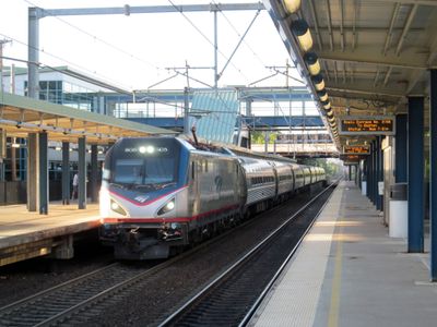
Route 128 station, rail station in Westwood, Massachusetts, United States

Route 128 station is a railway stop in Westwood with a straightforward building, open platform, and basic facilities including seating and clear signage. The layout helps travelers board trains quickly and move through the station without confusion.

The station has served for many years as a link between the town of Westwood and larger cities nearby. It functions as part of the regional transit network that connects local residents and visitors to other parts of the state.

The station takes its name from the nearby Route 128 highway, a major road that defines the area. This connection between the transit hub and the regional infrastructure reflects how transportation shapes the local identity.

The station features three elevators and two escalators that make moving between the lobby and platforms easy. High-level platforms allow passengers to board without steps, making the station accessible for all travelers.

The station is undergoing continuous updates with modern fare gates that require travelers to scan or tap their card to enter and exit the track area. These ongoing improvements increase security and make the boarding process smoother.

The community of curious travelers

AroundUs brings together thousands of curated places, local tips, and hidden gems, enriched daily by 60,000 contributors worldwide.

Start exploring
Location
Official opening
April 26, 1953
Address
50 University Avenue, Westwood, MA
GPS coordinates
42.21020,-71.14720
Latest update
February 17, 2026 02:00
Around this place
Fairbanks House
United States of America

Fairbanks House

4.1 km
Blue Hills Reservation
United States of America

Blue Hills Reservation

3.7 km
Great Blue Hill
United States of America

Great Blue Hill

2.7 km
Endicott Estate
United States of America

Endicott Estate

3.7 km
Blue Hill Meteorological Observatory
United States of America

Blue Hill Meteorological Observatory

2.7 km
United States of America

Camp Meigs

2.5 km
Eleanor Cabot Bradley Estate
United States of America

Eleanor Cabot Bradley Estate

2.5 km
Eustis Estate
United States of America

Eustis Estate

4.1 km
Fairview Cemetery
United States of America

Fairview Cemetery

4 km
Great Blue Hill Observation Tower
United States of America

Great Blue Hill Observation Tower

2.9 km
Paul's Bridge
United States of America

Paul's Bridge

3.4 km
Norfolk County Courthouse
United States of America

Norfolk County Courthouse

4.9 km
Eliot Memorial Bridge
United States of America

Eliot Memorial Bridge

2.9 km
Parson Barnard House
United States of America

Parson Barnard House

2.5 km
Norwood Memorial Municipal Building
United States of America

Norwood Memorial Municipal Building

4.7 km
United States of America

Dedham Public Library

4.8 km
Ames Schoolhouse
United States of America

Ames Schoolhouse

4.5 km
United States of America

Norfolk House

4.9 km
Comfort Station
United States of America

Comfort Station

2.6 km
Refreshment Pavilion
United States of America

Refreshment Pavilion

4.1 km
Wakefield Estate
United States of America

Wakefield Estate

2.8 km
First Church of Christ, Scientist
United States of America

First Church of Christ, Scientist

4.9 km
St. Mary's School and Asylum
United States of America

St. Mary's School and Asylum

4.9 km
19 Court Street
United States of America

19 Court Street

4.9 km
Canton Corner Historic District
United States of America

Canton Corner Historic District

4.1 km
Metropolitan District Commission Stable
United States of America

Metropolitan District Commission Stable

4.4 km
Redman Farm House
United States of America

Redman Farm House

3.6 km
Suffolk Resolves House
United States of America

Suffolk Resolves House

4.2 km
Show the full map
Reviews
Share your experience

No review yet

Discussions
Start a discussion...

No discussion yet

« Route 128 station - rail station in Westwood, Massachusetts, United States » is provided by Around Us (aroundus.com). Images and texts are derived from Wikimedia project under a Creative Commons license. You are allowed to copy, distribute, and modify copies of this page, under the conditions set by the license, as long as this note is clearly visible.

Discover hidden gems everywhere you go!

From secret cafés to breathtaking viewpoints, skip the crowded tourist spots and find places that match your style. Our app makes it easy with voice search, smart filtering, route optimization, and insider tips from travelers worldwide. Download now for the complete mobile experience.

Around Us App Screenshot

A unique approach to discovering new places

Le Figaro

All the places worth exploring

France Info

A tailor-made excursion in just a few clicks

20 Minutes

Around Us
Travel Guide & Maps
Download

Send to your phone

QR Code
1

Open the camera app on your mobile.

2

Point at the QR code with your camera. A notification will appear.

3

Tap the notification to open the link.