Paul's Bridge

Log in to your account

AroundUs is a community-driven map of interesting places, built by curious explorers like you. It grows with every review, story, and photo you share.
Connect to save your favorite spots, contribute locations, and create personalized routes.
Continue with Google
Continue with Apple
Continue with X
Continue with Facebook
Continue with email
By continuing, you accept our Terms and Conditions and our Privacy Policy
Create an account
Add to collection
Map
Suggest a change
Share

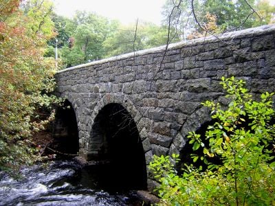
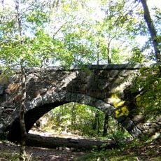
Paul's Bridge, Stone bridge on Neponset Valley Parkway, Massachusetts.

Paul's Bridge is a stone structure made of Quincy granite that crosses the Neponset River to connect Milton and southern Boston. The design features rounded arches and solid stone walls, with the main arches measured at 20 feet across the river.

Thomas Hollis Jr. built this structure in 1849 to replace an older crossing known as Hubbard's Bridge. A major reconstruction took place between 1932 and 1935 to ensure its durability.

The structure is named after Samuel Paul, who owned adjacent land when the bridge was built. Visitors can experience the historic connection between communities while crossing today.

The bridge provides vehicle access across the river and is easily reached from Neponset Valley Parkway. You can view the structure from both sides and get up close to see how the unmortared granite blocks fit together.

The granite used in the bridge came from quarries in Quincy, a town famous for granite production. This local material made the project practical and affordable when it was built.

Location: Massachusetts

GPS coordinates: 42.23444,-71.12250

Latest update: December 14, 2025 09:47

Photos
Around this place
Museum of Bad Art
United States of America

Museum of Bad Art

10.9 km
Fairbanks House
United States of America

Fairbanks House

3.9 km
Great Blue Hill
United States of America

Great Blue Hill

2.6 km
Endicott Estate
United States of America

Endicott Estate

3.5 km
Blue Hill Meteorological Observatory
United States of America

Blue Hill Meteorological Observatory

2.6 km
United States of America

Camp Meigs

1.1 km
George Wright Golf Course
United States of America

George Wright Golf Course

3.8 km
Eleanor Cabot Bradley Estate
United States of America

Eleanor Cabot Bradley Estate

3.9 km
Stony Brook Reservation
United States of America

Stony Brook Reservation

2.5 km
Eustis Estate
United States of America

Eustis Estate

1.3 km
Blue Hills Reservation Parkways
United States of America

Blue Hills Reservation Parkways

4.3 km
Great Blue Hill Observation Tower
United States of America

Great Blue Hill Observation Tower

2.5 km
Eliot Memorial Bridge
United States of America

Eliot Memorial Bridge

2.5 km
Parson Barnard House
United States of America

Parson Barnard House

3.2 km
Truman Parkway
United States of America

Truman Parkway

2.8 km
Stony Brook Reservation Parkways
United States of America

Stony Brook Reservation Parkways

4 km
Ames Schoolhouse
United States of America

Ames Schoolhouse

4.5 km
First Congregational Church of Hyde Park
United States of America

First Congregational Church of Hyde Park

2.6 km
Comfort Station
United States of America

Comfort Station

1.7 km
Refreshment Pavilion
United States of America

Refreshment Pavilion

3.5 km
Wakefield Estate
United States of America

Wakefield Estate

1.2 km
Brush Hill Historic District
United States of America

Brush Hill Historic District

1.6 km
Blue Hills Headquarters
United States of America

Blue Hills Headquarters

3.2 km
Metropolitan District Commission Stable
United States of America

Metropolitan District Commission Stable

3.3 km
Milton Centre Historic District
United States of America

Milton Centre Historic District

4.1 km
Scott's Woods Historic District
United States of America

Scott's Woods Historic District

3.6 km
Suffolk Resolves House
United States of America

Suffolk Resolves House

1.1 km
Old Barn
United States of America

Old Barn

3.2 km
Show the full map
Reviews

Visited this place? Tap the stars to rate it and share your experience / photos with the community! Try now! You can cancel it anytime.

« Paul's Bridge - Stone bridge on Neponset Valley Parkway, Massachusetts » is provided by Around Us (aroundus.com). Images and texts are derived from Wikimedia project under a Creative Commons license. You are allowed to copy, distribute, and modify copies of this page, under the conditions set by the license, as long as this note is clearly visible.

Discover hidden gems everywhere you go!

From secret cafés to breathtaking viewpoints, skip the crowded tourist spots and find places that match your style. Our app makes it easy with voice search, smart filtering, route optimization, and insider tips from travelers worldwide. Download now for the complete mobile experience.

Around Us App Screenshot

A unique approach to discovering new places

Le Figaro

All the places worth exploring

France Info

A tailor-made excursion in just a few clicks

20 Minutes