Enable Location

We need your location to show you interesting places around you

Discover nearby places

Find interesting locations and hidden gems around you

Precise directions

Get accurate directions and distances to places

Your location is never shared with other users. It's only used when you tap the location button.

Salina Stadium

Log in to your account

Start exploring — it's free

Trusted by 62,304 travelers worldwide

Continue with Google
Continue with Apple
or

We will send you a code to connect

By continuing, you accept our Terms and Conditions and our Privacy Policy

Check your inbox

We've sent a pincode in your inbox. Please enter the code below.

Salina Stadium

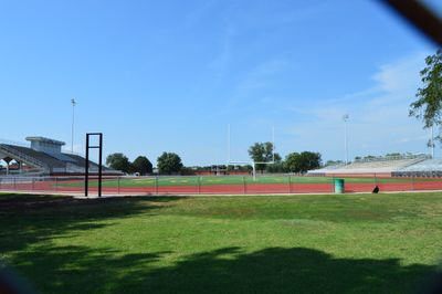
Salina Stadium, High school stadium in Salina, United States

Salina Stadium is a sports venue in Salina, Kansas, featuring artificial field turf and seating for approximately 7,000 spectators. The facility hosts football, soccer, and track events for school teams throughout the academic year.

The facility opened in 1965 on the campus of Salina High School Central as a basic athletic venue for the school community. A major renovation in 2017 transformed it with new artificial turf and improved spectator facilities.

The stadium serves as a gathering place for school communities, where soccer, football, and track competitions draw fans from across the city. The venue strengthens local school spirit and continues to be central to both high schools' athletic programs.

The stadium provides restroom facilities and concession stands for visitors attending events. Arriving early is wise to secure good seating and navigate the venue comfortably.

Until October 2015, Kansas Wesleyan University used this stadium for their athletic programs while their main campus facilities underwent renovation. This temporary use by a university was an uncommon role for a high school stadium.

The community of curious travelers

AroundUs brings together thousands of curated places, local tips, and hidden gems, enriched daily by 60,000 contributors worldwide.

Start exploring
Location
Inception
1965
Capacity
7000
GPS coordinates
38.81330,-97.60610
Latest update
December 14, 2025 13:00
Around this place
Dwight D. Eisenhower Presidential Library, Museum and Boyhood Home
United States of America

Dwight D. Eisenhower Presidential Library, Museum and Boyhood Home

36 km
Eisenhower Home
United States of America

Eisenhower Home

35.9 km
Rock City, Kansas
United States of America

Rock City, Kansas

32.9 km
Lebold Mansion
United States of America

Lebold Mansion

35.1 km
Atchison, Topeka and Santa Fe Railway 3415
United States of America

Atchison, Topeka and Santa Fe Railway 3415

35.2 km
Abilene and Smoky Valley Railroad
United States of America

Abilene and Smoky Valley Railroad

35.8 km
Rolling Hills Zoo
United States of America

Rolling Hills Zoo

14.5 km
Whiteford Archeological Site
United States of America

Whiteford Archeological Site

8.5 km
Sacred Heart Cathedral
United States of America

Sacred Heart Cathedral

3.1 km
Christ Cathedral
United States of America

Christ Cathedral

2.9 km
Masonic Temple
United States of America

Masonic Temple

2.4 km
Kansas Motorcycle Museum
United States of America

Kansas Motorcycle Museum

35 km
Swedish Pavilion
United States of America

Swedish Pavilion

28 km
Stiefel Theatre for the Performing Arts
United States of America

Stiefel Theatre for the Performing Arts

2.8 km
Hans Hanson House
United States of America

Hans Hanson House

34.6 km
Farmers State Bank
United States of America

Farmers State Bank

27.4 km
Johnson House
United States of America

Johnson House

26.6 km
Trinity Evangelical Lutheran Church
United States of America

Trinity Evangelical Lutheran Church

35.7 km
Smoky Valley Roller Mill
United States of America

Smoky Valley Roller Mill

28 km
United States of America

Rosberg-Holmgren-Clareen Block

27.3 km
United States of America

Berquist & Nelson Drugstore Building

27.3 km
Dickinson County Courthouse
United States of America

Dickinson County Courthouse

35.9 km
Abilene Downtown Historic District
United States of America

Abilene Downtown Historic District

35.9 km
Teichgraeber–Runbeck House
United States of America

Teichgraeber–Runbeck House

28.2 km
The Museum at Rolling Hills Zoo
United States of America

The Museum at Rolling Hills Zoo

14.3 km
Eliason Barn
United States of America

Eliason Barn

25.6 km
Lakewood Park Bridge
United States of America

Lakewood Park Bridge

3.7 km
Hobbs Creek Bridge
United States of America

Hobbs Creek Bridge

27.5 km
Show the full map
« Salina Stadium - High school stadium in Salina, United States » is provided by Around Us (aroundus.com). Images and texts are derived from Wikimedia project under a Creative Commons license. You are allowed to copy, distribute, and modify copies of this page, under the conditions set by the license, as long as this note is clearly visible.

Discover hidden gems everywhere you go!

From secret cafés to breathtaking viewpoints, skip the crowded tourist spots and find places that match your style. Our app makes it easy with voice search, smart filtering, route optimization, and insider tips from travelers worldwide. Download now for the complete mobile experience.

Around Us App Screenshot

A unique approach to discovering new places

Le Figaro

All the places worth exploring

France Info

A tailor-made excursion in just a few clicks

20 Minutes

Around Us
Travel Guide & Maps
Download

Send to your phone

QR Code
1

Open the camera app on your mobile.

2

Point at the QR code with your camera. A notification will appear.

3

Tap the notification to open the link.