Enable Location

We need your location to show you interesting places around you

Discover nearby places

Find interesting locations and hidden gems around you

Precise directions

Get accurate directions and distances to places

Your location is never shared with other users. It's only used when you tap the location button.

Salisbury High School

Log in to your account

Start exploring — it's free

Trusted by 62,481 travelers worldwide

Continue with Google
Continue with Apple
or

We will send you a code to connect

By continuing, you accept our Terms and Conditions and our Privacy Policy

Check your inbox

We've sent a pincode in your inbox. Please enter the code below.

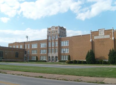
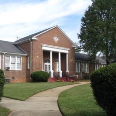
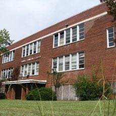
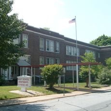
Salisbury High School, public, co-educational secondary school in Salisbury, North Carolina

Salisbury High School is a secondary institution in Salisbury, North Carolina, built in 1926 with Collegiate Gothic styling, featuring stone details and tall windows. The campus expanded over decades with additional structures and now serves approximately 1,000 students from surrounding neighborhoods.

The school opened in 1926 as Boyden High School and initially served white students only. It began desegregation in 1964 when the first Black students were admitted, and fully consolidated with J.C. Price High School in 1969, bringing all students together under one name.

The school represents a significant moment in the community's path toward integration. It remains a gathering place where students from different backgrounds study together in shared classrooms and hallways.

The school is located near downtown Salisbury on Lincolnton Road and is easily accessible to visitors. Listed on the National Register of Historic Places, the exterior and grounds can be viewed, with information available about its architecture and historical significance.

The school became a turning point in 1964 when Deborah Anderson, Herman Anderson, and Betty Pharr became the first Black students admitted, beginning Salisbury's desegregation process. This courageous act by three young people marked a pivotal moment in local history and the fight for equal education.

The community of curious travelers

AroundUs brings together thousands of curated places, local tips, and hidden gems, enriched daily by 60,000 contributors worldwide.

Start exploring
Location
Inception
1926
GPS coordinates
35.66472,-80.48472
Latest update
February 7, 2026 11:00
Around this place
North Carolina Transportation Museum
United States of America

North Carolina Transportation Museum

5 km
Salisbury National Cemetery
United States of America

Salisbury National Cemetery

1.1 km
Sacred Heart Catholic Church
United States of America

Sacred Heart Catholic Church

5.3 km
Hambley-Wallace House
United States of America

Hambley-Wallace House

610 m
Michael Braun House
United States of America

Michael Braun House

6.2 km
Salisbury Historic District
United States of America

Salisbury Historic District

1.4 km
McNeely-Strachan House
United States of America

McNeely-Strachan House

1 km
J. C. Price High School
United States of America

J. C. Price High School

1.7 km
Yadkin River Veterans Memorial Bridge
United States of America

Yadkin River Veterans Memorial Bridge

10.6 km
John Steele House
United States of America

John Steele House

2.6 km
Archibald Henderson Law Office
United States of America

Archibald Henderson Law Office

1.2 km
Bernhardt House
United States of America

Bernhardt House

1.5 km
Maxwell Chambers House
United States of America

Maxwell Chambers House

1.2 km
Mount Zion Baptist Church
United States of America

Mount Zion Baptist Church

1.7 km
Community Building
United States of America

Community Building

1.5 km
Walter McCanless House
United States of America

Walter McCanless House

2.5 km
Monroe Street School
United States of America

Monroe Street School

955 m
Grimes Mill
United States of America

Grimes Mill

2 km
Shaver Rental Houses District
United States of America

Shaver Rental Houses District

1.3 km
Shober Bridge
United States of America

Shober Bridge

1.6 km
Kesler Manufacturing Co.-Cannon Mills Co. Plant No. 7 Historic District
United States of America

Kesler Manufacturing Co.-Cannon Mills Co. Plant No. 7 Historic District

2.4 km
Salisbury Railroad Corridor Historic District
United States of America

Salisbury Railroad Corridor Historic District

1.9 km
North Long Street-Park Avenue Historic District
United States of America

North Long Street-Park Avenue Historic District

2.1 km
Calvin H. Wiley School
United States of America

Calvin H. Wiley School

279 m
Fulton Heights Historic District
United States of America

Fulton Heights Historic District

646 m
Ellis Street Graded School Historic District
United States of America

Ellis Street Graded School Historic District

1.5 km
Grubb-Sigmon-Weisiger House
United States of America

Grubb-Sigmon-Weisiger House

3 km
Old Stone House
United States of America

Old Stone House

6.3 km
Show the full map
« Salisbury High School - public, co-educational secondary school in Salisbury, North Carolina » is provided by Around Us (aroundus.com). Images and texts are derived from Wikimedia project under a Creative Commons license. You are allowed to copy, distribute, and modify copies of this page, under the conditions set by the license, as long as this note is clearly visible.

Discover hidden gems everywhere you go!

From secret cafés to breathtaking viewpoints, skip the crowded tourist spots and find places that match your style. Our app makes it easy with voice search, smart filtering, route optimization, and insider tips from travelers worldwide. Download now for the complete mobile experience.

Around Us App Screenshot

A unique approach to discovering new places

Le Figaro

All the places worth exploring

France Info

A tailor-made excursion in just a few clicks

20 Minutes

Around Us
Travel Guide & Maps
Download

Send to your phone

QR Code
1

Open the camera app on your mobile.

2

Point at the QR code with your camera. A notification will appear.

3

Tap the notification to open the link.