Enable Location

We need your location to show you interesting places around you

Discover nearby places

Find interesting locations and hidden gems around you

Precise directions

Get accurate directions and distances to places

Your location is never shared with other users. It's only used when you tap the location button.

Shenandoah Caverns

Log in to your account

Start exploring — it's free

Trusted by 61,981 travelers worldwide

Continue with Google
Continue with Apple
or

We will send you a code to connect

By continuing, you accept our Terms and Conditions and our Privacy Policy

Check your inbox

We've sent a pincode in your inbox. Please enter the code below.

Shenandoah Caverns

Shenandoah Caverns, Underground cave system in Quicksburg, Virginia

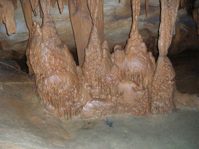
Shenandoah Caverns is an underground cave system that extends for one mile through seventeen connected chambers, displaying mineral formations such as stalactites, stalagmites, and flowstone. The passages showcase a variety of rock structures that have developed over thousands of years.

Railroad workers discovered the caverns in 1884 during Southern Railway construction when they noticed cold air flowing from an underground opening. This accidental discovery eventually led to the site's development as a destination for visitors.

The American Celebration on Parade exhibit displays retired parade floats from national celebrations, preserving pieces of American festival tradition. Visitors can see these floats displayed throughout the chambers and learn about the country's festive heritage.

The caverns maintain a constant underground temperature year-round and feature an elevator system that provides access to all areas of the cave system. Visitors should wear comfortable shoes and be prepared to walk through multiple levels of passages.

The Diamond Cascade formation creates natural patterns on the cave walls that resemble sparkling crystal structures. Rainbow Lake presents a water surface that mirrors surrounding mineral deposits and refracts light in subtle color variations.

The community of curious travelers

AroundUs brings together thousands of curated places, local tips, and hidden gems, enriched daily by 60,000 contributors worldwide.

Start exploring
Location
GPS coordinates
38.71560,-78.66930
Latest update
December 10, 2025 16:03
Around this place
New Market Battlefield State Historical Park
United States of America

New Market Battlefield State Historical Park

5.5 km
Meems Bottom Covered Bridge
United States of America

Meems Bottom Covered Bridge

1.3 km
Short Mountain
United States of America

Short Mountain

13.3 km
Mount Jackson Historic District
United States of America

Mount Jackson Historic District

4 km
Edinburg Mill
United States of America

Edinburg Mill

14.7 km
Zirkle Mill
United States of America

Zirkle Mill

4.9 km
Wilkins Farm
United States of America

Wilkins Farm

14.8 km
Fort Egypt
United States of America

Fort Egypt

13.5 km
Fort Philip Long
United States of America

Fort Philip Long

15.4 km
Plains Mill
United States of America

Plains Mill

8.2 km
Edinburg Historic District
United States of America

Edinburg Historic District

14.9 km
Dr. Christian Hockman House
United States of America

Dr. Christian Hockman House

16.3 km
The White House
United States of America

The White House

13.9 km
Lantz Mill
United States of America

Lantz Mill

15.5 km
New Market Historic District
United States of America

New Market Historic District

7.6 km
Campbell Farm
United States of America

Campbell Farm

15.7 km
Wall Brook Farm
United States of America

Wall Brook Farm

14.3 km
Mauck's Meetinghouse
United States of America

Mauck's Meetinghouse

15 km
David and Catherine Driver Farm
United States of America

David and Catherine Driver Farm

13.1 km
Heiston-Strickler House
United States of America

Heiston-Strickler House

15.1 km
John Beaver House
United States of America

John Beaver House

13.3 km
John Miley Maphis House
United States of America

John Miley Maphis House

15 km
Forestville Historic District
United States of America

Forestville Historic District

4.7 km
Bowman-Zirkle Farm
United States of America

Bowman-Zirkle Farm

10 km
Benjamin Wierman House
United States of America

Benjamin Wierman House

7.7 km
Massanutton Heights
United States of America

Massanutton Heights

12.3 km
Timberville Historic District
United States of America

Timberville Historic District

12.4 km
Clem-Kagey Farm
United States of America

Clem-Kagey Farm

9.7 km
Show the full map
« Shenandoah Caverns - Underground cave system in Quicksburg, Virginia » is provided by Around Us (aroundus.com). Images and texts are derived from Wikimedia project under a Creative Commons license. You are allowed to copy, distribute, and modify copies of this page, under the conditions set by the license, as long as this note is clearly visible.

Discover hidden gems everywhere you go!

From secret cafés to breathtaking viewpoints, skip the crowded tourist spots and find places that match your style. Our app makes it easy with voice search, smart filtering, route optimization, and insider tips from travelers worldwide. Download now for the complete mobile experience.

Around Us App Screenshot

A unique approach to discovering new places

Le Figaro

All the places worth exploring

France Info

A tailor-made excursion in just a few clicks

20 Minutes

Around Us
Travel Guide & Maps
Download

Send to your phone

QR Code
1

Open the camera app on your mobile.

2

Point at the QR code with your camera. A notification will appear.

3

Tap the notification to open the link.