Enable Location

We need your location to show you interesting places around you

Discover nearby places

Find interesting locations and hidden gems around you

Precise directions

Get accurate directions and distances to places

Your location is never shared with other users. It's only used when you tap the location button.

Log in to your account

Start exploring — it's free

Trusted by 63,118 travelers worldwide

Continue with Google
Continue with Apple
or

We will send you a code to connect

By continuing, you accept our Terms and Conditions and our Privacy Policy

Check your inbox

We've sent a pincode in your inbox. Please enter the code below.

Shrewsbury Peak
Discussion Reviews Photo
1.1k Popularity

Shrewsbury Peak, Mountain summit in Rutland County, Vermont, United States.

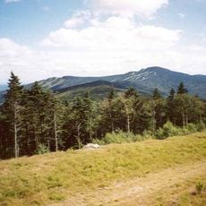
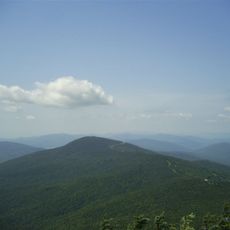
Shrewsbury Peak is a mountain summit in the Green Mountains that rises to about 3,740 feet and dominates the landscape of Rutland County. The slopes are covered with a mix of deciduous and coniferous forest that changes character as you go higher up the mountain.

The peak formed as part of the ancient Appalachian Mountain building process hundreds of millions of years ago. Its rocks contain deposits of magnetite, muscovite, pyrite, quartz, and tourmaline that make it geologically significant.

Local mineral collecting groups regularly organize expeditions to study and document the various geological specimens found around the mountain's terrain.

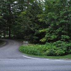
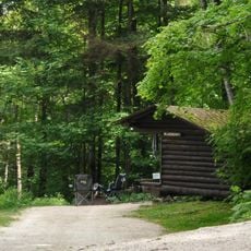
The summit is accessible by marked hiking trails that range from easier to more challenging depending on your route choice. Winter visitors can enjoy snowshoeing and other cold-weather activities when conditions permit.

The location sits at the boundary between two distinct forest zones shaped by elevation and local weather patterns. This meeting point creates an unusual plant diversity where northern hardwood forests transition into spruce-fir woodlands higher up.

The community of curious travelers

AroundUs brings together thousands of curated places, local tips, and hidden gems, enriched daily by 60,000 contributors worldwide.

Start exploring
Location
GPS coordinates
43.57812,-72.80538
Latest update
December 14, 2025 18:40
Around this place
Killington Peak
United States of America

Killington Peak

3.2 km
Coolidge Homestead
United States of America

Coolidge Homestead

8.2 km
Pico Peak
United States of America

Pico Peak

7.3 km
Brown Covered Bridge
United States of America

Brown Covered Bridge

9.3 km
Gifford Woods State Park
United States of America

Gifford Woods State Park

10.9 km
Coolidge State Park
United States of America

Coolidge State Park

8.9 km
Paramount Theatre
United States of America

Paramount Theatre

14.3 km
Crowley Cheese Factory
United States of America

Crowley Cheese Factory

17.2 km
St. Peter's Church and Mount St. Joseph Convent Complex
United States of America

St. Peter's Church and Mount St. Joseph Convent Complex

14.8 km
Clementwood
United States of America

Clementwood

16.4 km
Camp Plymouth State Park
United States of America

Camp Plymouth State Park

14.4 km
Laurel Glen Mausoleum-Laurel Hall
United States of America

Laurel Glen Mausoleum-Laurel Hall

12 km
Kingsley Grist Mill Historic District
United States of America

Kingsley Grist Mill Historic District

12.5 km
Linden Terrace
United States of America

Linden Terrace

15.2 km
Rutland Jewish Center
United States of America

Rutland Jewish Center

14.7 km
Chaffee-Moloney Houses
United States of America

Chaffee-Moloney Houses

15.3 km
Proctor-Clement House
United States of America

Proctor-Clement House

15.6 km
Anthony Scoville House
United States of America

Anthony Scoville House

11.8 km
Longfellow School
United States of America

Longfellow School

14.4 km
The Brick Church
United States of America

The Brick Church

14.9 km
Cold River Bridge
United States of America

Cold River Bridge

13 km
Watkins School
United States of America

Watkins School

15.7 km
Plymouth Historic District
United States of America

Plymouth Historic District

8.4 km
Rutland Courthouse Historic District
United States of America

Rutland Courthouse Historic District

14 km
Saddlebow Farm
United States of America

Saddlebow Farm

15.5 km
Arthur Perkins House
United States of America

Arthur Perkins House

13.3 km
Bridgewater Corners Bridge
United States of America

Bridgewater Corners Bridge

12 km
Wonderfeet Kid's Museum
United States of America

Wonderfeet Kid's Museum

14.5 km
Show the full map
Reviews
Share your experience

No review yet

Discussions
Start a discussion...

No discussion yet

« Shrewsbury Peak - Mountain summit in Rutland County, Vermont, United States » is provided by Around Us (aroundus.com). Images and texts are derived from Wikimedia project under a Creative Commons license. You are allowed to copy, distribute, and modify copies of this page, under the conditions set by the license, as long as this note is clearly visible.

Discover hidden gems everywhere you go!

From secret cafés to breathtaking viewpoints, skip the crowded tourist spots and find places that match your style. Our app makes it easy with voice search, smart filtering, route optimization, and insider tips from travelers worldwide. Download now for the complete mobile experience.

Around Us App Screenshot

A unique approach to discovering new places

Le Figaro

All the places worth exploring

France Info

A tailor-made excursion in just a few clicks

20 Minutes

Around Us
Travel Guide & Maps
Download

Send to your phone

QR Code
1

Open the camera app on your mobile.

2

Point at the QR code with your camera. A notification will appear.

3

Tap the notification to open the link.