Enable Location

We need your location to show you interesting places around you

Discover nearby places

Find interesting locations and hidden gems around you

Precise directions

Get accurate directions and distances to places

Your location is never shared with other users. It's only used when you tap the location button.

South Danbury Christian Church

Log in to your account

Start exploring — it's free

Trusted by 62,371 travelers worldwide

Continue with Google
Continue with Apple
or

We will send you a code to connect

By continuing, you accept our Terms and Conditions and our Privacy Policy

Check your inbox

We've sent a pincode in your inbox. Please enter the code below.

South Danbury Christian Church, church building in New Hampshire, United States of America

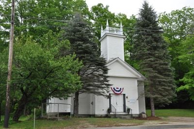
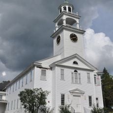
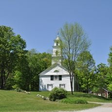
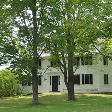
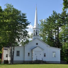
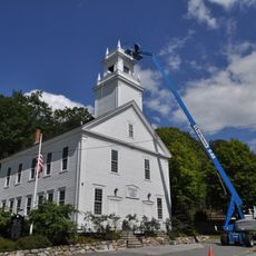
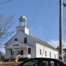
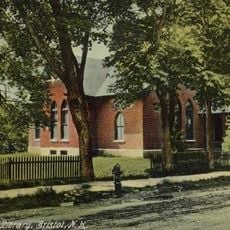
South Danbury Christian Church is a simple wooden building in New Hampshire with clapboard siding and a gabled roof. It features a square tower with decorative corner details, small windows, and a plain entrance porch with double doors.

The building was constructed in 1867 by members of the local congregation, which had been founded just one year earlier. The community financed the project by selling pews, a common practice for funding church buildings during that era.

The church carries the name of a Christian congregation and reflects the religious meaning this place holds for residents. It serves not only for worship but also as a gathering spot where neighbors meet, share news, and support each other.

The building sits north of main road US 4 in a rural area with a simple parking lot nearby. It is used on weekdays for various activities such as senior gatherings and charity services, remaining a quiet spot for visitors to access.

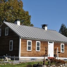
The church was financed by selling pews, an unusual funding system for community buildings of that era. The roof was replaced in the 1970s while the exterior appearance has otherwise remained unchanged since the 1800s.

The community of curious travelers

AroundUs brings together thousands of curated places, local tips, and hidden gems, enriched daily by 60,000 contributors worldwide.

Start exploring
Location
GPS coordinates
43.48278,-71.88667
Latest update
February 9, 2026 07:40
Around this place
Mount Kearsarge
United States of America

Mount Kearsarge

11.3 km
Mount Cardigan
United States of America

Mount Cardigan

18.7 km
The Fells
United States of America

The Fells

19.5 km
Wellington State Park
United States of America

Wellington State Park

18.4 km
Ragged Mountain
United States of America

Ragged Mountain

3.5 km
Winslow State Park
United States of America

Winslow State Park

10.4 km
Cardigan Mountain State Park
United States of America

Cardigan Mountain State Park

18.4 km
Bog Bridge
United States of America

Bog Bridge

6 km
Kearsarge Mountain State Forest
United States of America

Kearsarge Mountain State Forest

11.4 km
Bristol Town Hall
United States of America

Bristol Town Hall

17.3 km
Keniston Bridge
United States of America

Keniston Bridge

6.7 km
Baptist New Meeting House
United States of America

Baptist New Meeting House

10.7 km
Gardner Memorial Wayside Park
United States of America

Gardner Memorial Wayside Park

7.2 km
South Sutton Meeting House
United States of America

South Sutton Meeting House

18.5 km
Matthew Harvey House
United States of America

Matthew Harvey House

13.5 km
Dr. Solomon M. Whipple House
United States of America

Dr. Solomon M. Whipple House

11.1 km
Central Square Historic District
United States of America

Central Square Historic District

17.1 km
Salisbury Academy Building
United States of America

Salisbury Academy Building

18 km
Hill Center Church
United States of America

Hill Center Church

15.6 km
Protectworth Tavern
United States of America

Protectworth Tavern

12.3 km
Springfield Town Hall and Howard Memorial Methodist Church
United States of America

Springfield Town Hall and Howard Memorial Methodist Church

13.2 km
Pillsbury Memorial Hall
United States of America

Pillsbury Memorial Hall

17.4 km
East Andover Village Center Historic District
United States of America

East Andover Village Center Historic District

11.5 km
Gershom Durgin House
United States of America

Gershom Durgin House

10.4 km
Minot-Sleeper Library
United States of America

Minot-Sleeper Library

16.9 km
Hersey Farms Historic District
United States of America

Hersey Farms Historic District

12.7 km
Murray Hill Summer Home District
United States of America

Murray Hill Summer Home District

9.7 km
Camps Kenwood and Evergreen
United States of America

Camps Kenwood and Evergreen

2.8 km
Show the full map
« South Danbury Christian Church - church building in New Hampshire, United States of America » is provided by Around Us (aroundus.com). Images and texts are derived from Wikimedia project under a Creative Commons license. You are allowed to copy, distribute, and modify copies of this page, under the conditions set by the license, as long as this note is clearly visible.

Discover hidden gems everywhere you go!

From secret cafés to breathtaking viewpoints, skip the crowded tourist spots and find places that match your style. Our app makes it easy with voice search, smart filtering, route optimization, and insider tips from travelers worldwide. Download now for the complete mobile experience.

Around Us App Screenshot

A unique approach to discovering new places

Le Figaro

All the places worth exploring

France Info

A tailor-made excursion in just a few clicks

20 Minutes

Around Us
Travel Guide & Maps
Download

Send to your phone

QR Code
1

Open the camera app on your mobile.

2

Point at the QR code with your camera. A notification will appear.

3

Tap the notification to open the link.