Enable Location

We need your location to show you interesting places around you

Discover nearby places

Find interesting locations and hidden gems around you

Precise directions

Get accurate directions and distances to places

Your location is never shared with other users. It's only used when you tap the location button.

Ragged Mountain

Log in to your account

Start exploring — it's free

Trusted by 62,984 travelers worldwide

Continue with Google
Continue with Apple
or

We will send you a code to connect

By continuing, you accept our Terms and Conditions and our Privacy Policy

Check your inbox

We've sent a pincode in your inbox. Please enter the code below.

Ragged Mountain
Discussion Reviews 1 Photos
3k Popularity

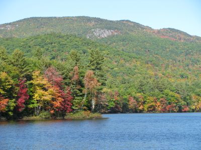
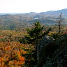
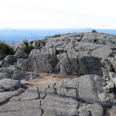
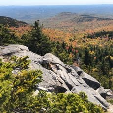
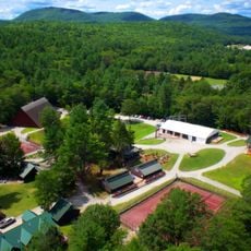
Ragged Mountain, Mountain summit in New Hampshire, US.

Ragged Mountain is a forested summit in New Hampshire that rises to about 2,260 feet (690 meters) and serves as both a recreation destination and natural landmark. The slopes feature a mix of wooded areas and open terrain that create distinct zones for different activities.

Ragged Mountain became a winter sports destination starting in the 1960s and has evolved into a modern recreation facility over the decades. This transformation reflects the region's growing interest in year-round mountain activities.

Local communities gather at Ragged Mountain throughout winter for skiing competitions and seasonal festivals that strengthen regional connections.

The mountain is accessible via marked trails suited for different skill levels and open throughout the year. Conditions change significantly with the seasons, so visitors should prepare appropriate gear for their chosen time of visit.

During winter months, the mountain's elevation and position create favorable conditions for consistent natural snow accumulation on northern-facing slopes.

The community of curious travelers

AroundUs brings together thousands of curated places, local tips, and hidden gems, enriched daily by 60,000 contributors worldwide.

Start exploring
Location
Elevation above the sea
690 m
GPS coordinates
43.47217,-71.84546
Latest update
December 12, 2025 12:04
Around this place
Mount Kearsarge
United States of America

Mount Kearsarge

9.9 km
Daniel Webster Family Home
United States of America

Daniel Webster Family Home

17.3 km
Winslow State Park
United States of America

Winslow State Park

9.3 km
Sulphite Railroad Bridge
United States of America

Sulphite Railroad Bridge

17.2 km
Concord Historic District
United States of America

Concord Historic District

17.2 km
Bog Bridge
United States of America

Bog Bridge

5.1 km
South Danbury Christian Church
United States of America

South Danbury Christian Church

3.5 km
Kearsarge Mountain State Forest
United States of America

Kearsarge Mountain State Forest

10 km
Bristol Town Hall
United States of America

Bristol Town Hall

16.1 km
Keniston Bridge
United States of America

Keniston Bridge

4.2 km
Baptist New Meeting House
United States of America

Baptist New Meeting House

12.6 km
Gardner Memorial Wayside Park
United States of America

Gardner Memorial Wayside Park

10.6 km
South Sutton Meeting House
United States of America

South Sutton Meeting House

18.4 km
Matthew Harvey House
United States of America

Matthew Harvey House

14.2 km
Dr. Solomon M. Whipple House
United States of America

Dr. Solomon M. Whipple House

13 km
Central Square Historic District
United States of America

Central Square Historic District

15.9 km
Salisbury Academy Building
United States of America

Salisbury Academy Building

14.7 km
Hill Center Church
United States of America

Hill Center Church

13 km
Springfield Town Hall and Howard Memorial Methodist Church
United States of America

Springfield Town Hall and Howard Memorial Methodist Church

16.6 km
Protectworth Tavern
United States of America

Protectworth Tavern

15.8 km
Pillsbury Memorial Hall
United States of America

Pillsbury Memorial Hall

17.7 km
East Andover Village Center Historic District
United States of America

East Andover Village Center Historic District

8 km
Gershom Durgin House
United States of America

Gershom Durgin House

6.9 km
Minot-Sleeper Library
United States of America

Minot-Sleeper Library

15.7 km
Hersey Farms Historic District
United States of America

Hersey Farms Historic District

9.3 km
Franklin Falls Historic District
United States of America

Franklin Falls Historic District

16.3 km
Murray Hill Summer Home District
United States of America

Murray Hill Summer Home District

8.5 km
Camps Kenwood and Evergreen
United States of America

Camps Kenwood and Evergreen

3.7 km
Show the full map
Reviews
Share your experience

No review yet

Discussions
Start a discussion...

No discussion yet

« Ragged Mountain - Mountain summit in New Hampshire, US » is provided by Around Us (aroundus.com). Images and texts are derived from Wikimedia project under a Creative Commons license. You are allowed to copy, distribute, and modify copies of this page, under the conditions set by the license, as long as this note is clearly visible.

Discover hidden gems everywhere you go!

From secret cafés to breathtaking viewpoints, skip the crowded tourist spots and find places that match your style. Our app makes it easy with voice search, smart filtering, route optimization, and insider tips from travelers worldwide. Download now for the complete mobile experience.

Around Us App Screenshot

A unique approach to discovering new places

Le Figaro

All the places worth exploring

France Info

A tailor-made excursion in just a few clicks

20 Minutes

Around Us
Travel Guide & Maps
Download

Send to your phone

QR Code
1

Open the camera app on your mobile.

2

Point at the QR code with your camera. A notification will appear.

3

Tap the notification to open the link.