Enable Location

We need your location to show you interesting places around you

Discover nearby places

Find interesting locations and hidden gems around you

Precise directions

Get accurate directions and distances to places

Your location is never shared with other users. It's only used when you tap the location button.

Bog Bridge

Log in to your account

Start exploring — it's free

Trusted by 62,370 travelers worldwide

Continue with Google
Continue with Apple
or

We will send you a code to connect

By continuing, you accept our Terms and Conditions and our Privacy Policy

Check your inbox

We've sent a pincode in your inbox. Please enter the code below.

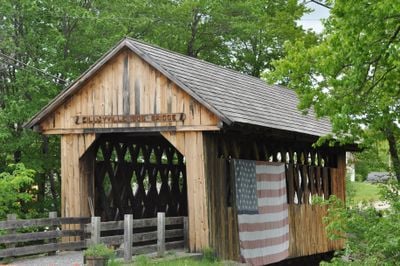
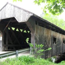
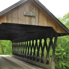
Bog Bridge, pont américain

Bog Bridge is a covered wooden bridge in Andover that crosses Pleasant Brook and now serves only pedestrians. It uses the Town lattice truss design, where overlapping wooden planks form a crisscross pattern supported by horizontal beams called chords.

The bridge was built in 1887 by Prentice C. Atwood, a skilled carpenter who also built another nearby bridge. After a flood in 1938 damaged the abutments, the west side was repaired with mortar, and in 1957 the bridge was straightened to correct a slight lean.

The bridge is known locally by two names: Bog Bridge and Cilleyville Bridge, a naming confusion that arose from another nearby bridge with the same historical designation. This dual identity reflects how the structure is woven into the community's local knowledge and memory.

The bridge is accessible to pedestrians only and features small side openings that allow natural light in and provide views. The floor is made of heavy wooden planks in two layers that create a smooth walkway, while approach roads are covered with gravel and grass.

This bridge lacks the lateral braces that typically stabilize many other covered bridges of its kind. Because it is relatively short, builders decided these supports were unnecessary, yet the structure has proven remarkably durable without them.

The community of curious travelers

AroundUs brings together thousands of curated places, local tips, and hidden gems, enriched daily by 60,000 contributors worldwide.

Start exploring
Location
GPS coordinates
43.43030,-71.86970
Latest update
February 9, 2026 07:41
Around this place
Mount Kearsarge
United States of America

Mount Kearsarge

5.3 km
The Fells
United States of America

The Fells

16.8 km
Ragged Mountain
United States of America

Ragged Mountain

5.1 km
Daniel Webster Family Home
United States of America

Daniel Webster Family Home

17.8 km
Winslow State Park
United States of America

Winslow State Park

4.5 km
Waterloo Historic District
United States of America

Waterloo Historic District

15.8 km
Waterloo Covered Bridge
United States of America

Waterloo Covered Bridge

15.9 km
South Danbury Christian Church
United States of America

South Danbury Christian Church

6 km
Kearsarge Mountain State Forest
United States of America

Kearsarge Mountain State Forest

5.4 km
Dalton Covered Bridge
United States of America

Dalton Covered Bridge

17.7 km
Old Webster Meeting House
United States of America

Old Webster Meeting House

16.6 km
New Hampshire Telephone Museum
United States of America

New Hampshire Telephone Museum

17.3 km
Keniston Bridge
United States of America

Keniston Bridge

2.7 km
Baptist New Meeting House
United States of America

Baptist New Meeting House

9.1 km
Gardner Memorial Wayside Park
United States of America

Gardner Memorial Wayside Park

10.4 km
South Sutton Meeting House
United States of America

South Sutton Meeting House

13.3 km
Matthew Harvey House
United States of America

Matthew Harvey House

9.5 km
Dr. Solomon M. Whipple House
United States of America

Dr. Solomon M. Whipple House

9.5 km
Salisbury Academy Building
United States of America

Salisbury Academy Building

13.7 km
Hill Center Church
United States of America

Hill Center Church

17.1 km
Springfield Town Hall and Howard Memorial Methodist Church
United States of America

Springfield Town Hall and Howard Memorial Methodist Church

16.2 km
Protectworth Tavern
United States of America

Protectworth Tavern

16 km
Pillsbury Memorial Hall
United States of America

Pillsbury Memorial Hall

12.7 km
East Andover Village Center Historic District
United States of America

East Andover Village Center Historic District

10.4 km
Gershom Durgin House
United States of America

Gershom Durgin House

8.1 km
Hersey Farms Historic District
United States of America

Hersey Farms Historic District

12.1 km
Murray Hill Summer Home District
United States of America

Murray Hill Summer Home District

13.6 km
Camps Kenwood and Evergreen
United States of America

Camps Kenwood and Evergreen

3.3 km
Show the full map
« Bog Bridge - pont américain » is provided by Around Us (aroundus.com). Images and texts are derived from Wikimedia project under a Creative Commons license. You are allowed to copy, distribute, and modify copies of this page, under the conditions set by the license, as long as this note is clearly visible.

Discover hidden gems everywhere you go!

From secret cafés to breathtaking viewpoints, skip the crowded tourist spots and find places that match your style. Our app makes it easy with voice search, smart filtering, route optimization, and insider tips from travelers worldwide. Download now for the complete mobile experience.

Around Us App Screenshot

A unique approach to discovering new places

Le Figaro

All the places worth exploring

France Info

A tailor-made excursion in just a few clicks

20 Minutes

Around Us
Travel Guide & Maps
Download

Send to your phone

QR Code
1

Open the camera app on your mobile.

2

Point at the QR code with your camera. A notification will appear.

3

Tap the notification to open the link.