Enable Location

We need your location to show you interesting places around you

Discover nearby places

Find interesting locations and hidden gems around you

Precise directions

Get accurate directions and distances to places

Your location is never shared with other users. It's only used when you tap the location button.

Mount Kearsarge

Log in to your account

Start exploring — it's free

Trusted by 61,888 travelers worldwide

Continue with Google
Continue with Apple
or

We will send you a code to connect

By continuing, you accept our Terms and Conditions and our Privacy Policy

Check your inbox

We've sent a pincode in your inbox. Please enter the code below.

Mount Kearsarge

Mount Kearsarge, Mountain summit in Merrimack County, New Hampshire, United States.

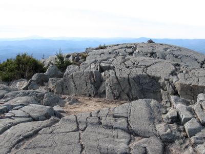
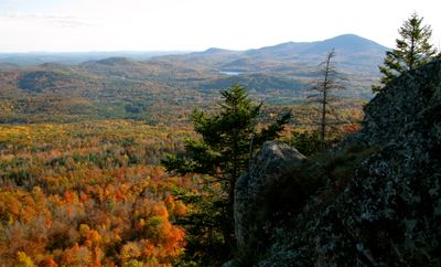
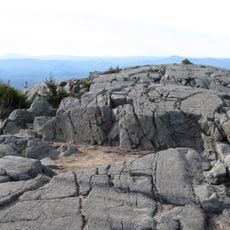
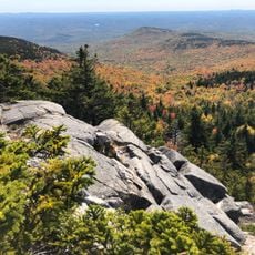
Mount Kearsarge is a 2,935 ft (894 m) summit in Merrimack County with a bare rocky top. The views from its peak stretch across New Hampshire and reach into Vermont on clear days.

A forest fire in 1796 destroyed the trees covering the summit and created the bare landscape seen today. The mountain has maintained this exposed appearance for centuries.

The Winslow Trail honors Admiral John Winslow, commander of USS Kearsarge, who defeated CSS Alabama during a Civil War naval battle in the English Channel.

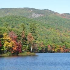
Two routes lead to the summit: trails from Winslow State Park on the west side and paths from Rollins State Park via Kearsarge Mountain Road on the south side. Both options offer access to the open peak and its views.

On clear days, Boston's skyscrapers are visible from the summit despite being about 80 miles away. This distant view showcases the elevation and clarity available from the peak.

The community of curious travelers

AroundUs brings together thousands of curated places, local tips, and hidden gems, enriched daily by 60,000 contributors worldwide.

Start exploring
Location
GPS coordinates
43.38345,-71.85709
Latest update
December 7, 2025 10:08
Around this place
The Fells
United States of America

The Fells

15.7 km
Ragged Mountain
United States of America

Ragged Mountain

9.9 km
Daniel Webster Family Home
United States of America

Daniel Webster Family Home

16.8 km
Winslow State Park
United States of America

Winslow State Park

1.1 km
Bement Covered Bridge
United States of America

Bement Covered Bridge

15.4 km
Waterloo Historic District
United States of America

Waterloo Historic District

10.6 km
Bog Bridge
United States of America

Bog Bridge

5.3 km
Waterloo Covered Bridge
United States of America

Waterloo Covered Bridge

10.6 km
South Danbury Christian Church
United States of America

South Danbury Christian Church

11.3 km
Kearsarge Mountain State Forest
United States of America

Kearsarge Mountain State Forest

45 m
Dalton Covered Bridge
United States of America

Dalton Covered Bridge

12.4 km
Old Webster Meeting House
United States of America

Old Webster Meeting House

12.8 km
New Hampshire Telephone Museum
United States of America

New Hampshire Telephone Museum

12 km
Keniston Bridge
United States of America

Keniston Bridge

6 km
Baptist New Meeting House
United States of America

Baptist New Meeting House

10.5 km
Gardner Memorial Wayside Park
United States of America

Gardner Memorial Wayside Park

14.7 km
South Sutton Meeting House
United States of America

South Sutton Meeting House

9.4 km
Center Meetinghouse
United States of America

Center Meetinghouse

16 km
Matthew Harvey House
United States of America

Matthew Harvey House

8.1 km
Dr. Solomon M. Whipple House
United States of America

Dr. Solomon M. Whipple House

10.8 km
Salisbury Academy Building
United States of America

Salisbury Academy Building

11.5 km
Bradford Town Hall
United States of America

Bradford Town Hall

15.3 km
Pillsbury Memorial Hall
United States of America

Pillsbury Memorial Hall

9.6 km
East Andover Village Center Historic District
United States of America

East Andover Village Center Historic District

12.2 km
Lower Warner Meetinghouse
United States of America

Lower Warner Meetinghouse

13 km
Gershom Durgin House
United States of America

Gershom Durgin House

9.6 km
Hersey Farms Historic District
United States of America

Hersey Farms Historic District

14.1 km
Camps Kenwood and Evergreen
United States of America

Camps Kenwood and Evergreen

8.5 km
Show the full map
« Mount Kearsarge - Mountain summit in Merrimack County, New Hampshire, United States » is provided by Around Us (aroundus.com). Images and texts are derived from Wikimedia project under a Creative Commons license. You are allowed to copy, distribute, and modify copies of this page, under the conditions set by the license, as long as this note is clearly visible.

Discover hidden gems everywhere you go!

From secret cafés to breathtaking viewpoints, skip the crowded tourist spots and find places that match your style. Our app makes it easy with voice search, smart filtering, route optimization, and insider tips from travelers worldwide. Download now for the complete mobile experience.

Around Us App Screenshot

A unique approach to discovering new places

Le Figaro

All the places worth exploring

France Info

A tailor-made excursion in just a few clicks

20 Minutes

Around Us
Travel Guide & Maps
Download

Send to your phone

QR Code
1

Open the camera app on your mobile.

2

Point at the QR code with your camera. A notification will appear.

3

Tap the notification to open the link.