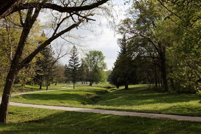
St. Joseph Parkway, Historic parkway system in St. Joseph, Missouri.
St. Joseph Parkway is an extended network spanning roughly 26 miles that connects recreational areas throughout the city with paved paths and hiking routes. The system links sports facilities, arenas, parks, and natural areas, providing access points for both walking and outdoor activities.
Landscape architect George Burnap designed this parkway system in 1918, making the city an early adopter of comprehensive park planning in America. The project emerged during a period of growth when cities were reimagining their public spaces.
The parkway serves as a gathering place where locals exercise and celebrate community events throughout the year. Different sections connect neighborhoods together, making it a social hub for residents from across the city.
The network can be accessed from multiple entry points throughout the city, allowing visitors to choose routes matching their interests and fitness level. Different sections offer varying terrain, so it helps to plan which areas suit your preferred activity.
The layout incorporates Renaissance design principles, which can be seen in how the different routes are arranged and interconnected throughout the city. This classical approach to planning gives the system an underlying sense of harmony.
The community of curious travelers
AroundUs brings together thousands of curated places, local tips, and hidden gems, enriched daily by 60,000 contributors worldwide.