Enable Location

We need your location to show you interesting places around you

Discover nearby places

Find interesting locations and hidden gems around you

Precise directions

Get accurate directions and distances to places

Your location is never shared with other users. It's only used when you tap the location button.

Pony Express Bridge

Log in to your account

Start exploring — it's free

Trusted by 61,508 travelers worldwide

Continue with Google
Continue with Apple
or

We will send you a code to connect

By continuing, you accept our Terms and Conditions and our Privacy Policy

Check your inbox

We've sent a pincode in your inbox. Please enter the code below.

Pony Express Bridge

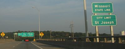
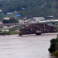
Pony Express Bridge, Highway bridge between Elwood and St. Joseph, United States

Description

The Pony Express Bridge comprises two parallel steel structures that span the Missouri River, linking Kansas and Missouri via U.S. Route 36. The twin design allows traffic to flow efficiently in both directions across this major waterway crossing.

History

The present structure was built in 1983 to replace an earlier truss bridge from 1929 that crossed near the original Pony Express route. This evolution reflects changing engineering standards and the growing demands of regional transportation over several decades.

Culture

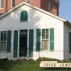
The bridge stands near where the Pony Express mail service once launched westward journeys, making it a physical landmark tied to American frontier communication. The crossing carries symbolic weight as a gateway to the historic route that connected distant regions.

Practical

The crossing provides direct access to St. Joseph's historic district and functions as a primary route for vehicles traveling between the two states. Traffic flows steadily, especially during peak hours, so plan your visit when congestion is lighter.

Did you know?

The bridge passes over land that once belonged to Johnny Fry's family, the first Pony Express rider, creating a tangible link to the service's earliest days. This intersection of modern infrastructure with frontier history adds depth to what might otherwise appear as a simple river crossing.

Location
Location
Inception
1983
Official opening
1983
GPS coordinates
39.74880,-94.85970
Latest update
December 14, 2025 14:45

AroundUs brings together thousands of curated places, local tips, and hidden gems, enriched daily by 60,000 contributors worldwide. Discover all places nearby (Missouri).

Around this place
Jesse James Home Museum
United States of America

Jesse James Home Museum

1.5 km
Patee House
United States of America

Patee House

1.5 km
Pony Express Museum
United States of America

Pony Express Museum

1.2 km
St. Joseph Swing Bridge
United States of America

St. Joseph Swing Bridge

526 m
German-American Bank Building
United States of America

German-American Bank Building

2 km
St. Joseph Parkway
United States of America

St. Joseph Parkway

1.7 km
South Fourth Street Commercial Historic District
United States of America

South Fourth Street Commercial Historic District

1.7 km
Robidoux School
United States of America

Robidoux School

2.1 km
St. Joseph City Hall
United States of America

St. Joseph City Hall

2.5 km
Corby-Forsee Building
United States of America

Corby-Forsee Building

2 km
St. Joseph Public Library
United States of America

St. Joseph Public Library

2.2 km
Western Tablet and Stationery Company, Building No. 2
United States of America

Western Tablet and Stationery Company, Building No. 2

1.5 km
Buchanan County Courthouse
United States of America

Buchanan County Courthouse

2.2 km
Museum Hill Historic District
United States of America

Museum Hill Historic District

2.2 km
Missouri Valley Trust Company Historic District
United States of America

Missouri Valley Trust Company Historic District

2 km
Patee House
United States of America

Patee House

1.5 km
Burnside-Sandusky Gothic House
United States of America

Burnside-Sandusky Gothic House

1.7 km
Neely Elementary School
United States of America

Neely Elementary School

1.2 km
Wholesale Row Historic District
United States of America

Wholesale Row Historic District

2.1 km
Robidoux Hill Historic District
United States of America

Robidoux Hill Historic District

2.6 km
Virginia Flats
United States of America

Virginia Flats

2.6 km
Ryan Block
United States of America

Ryan Block

2.7 km
John D. Richardson Dry Goods Company
United States of America

John D. Richardson Dry Goods Company

2.2 km
Alois Herbert Double House
United States of America

Alois Herbert Double House

1.9 km
Wyeth Flats
United States of America

Wyeth Flats

2.5 km
Charles A. and Annie Buddy House
United States of America

Charles A. and Annie Buddy House

1.9 km
Central-North Commercial Historic District
United States of America

Central-North Commercial Historic District

2.1 km
Missouri Theatre
United States of America

Missouri Theatre

2.1 km
Show the full map
« Pony Express Bridge - Highway bridge between Elwood and St. Joseph, United States » is provided by Around Us (aroundus.com). Images and texts are derived from Wikimedia project under a Creative Commons license. You are allowed to copy, distribute, and modify copies of this page, under the conditions set by the license, as long as this note is clearly visible.

Discover hidden gems everywhere you go!

From secret cafés to breathtaking viewpoints, skip the crowded tourist spots and find places that match your style. Our app makes it easy with voice search, smart filtering, route optimization, and insider tips from travelers worldwide. Download now for the complete mobile experience.

Around Us App Screenshot

A unique approach to discovering new places

Le Figaro

All the places worth exploring

France Info

A tailor-made excursion in just a few clicks

20 Minutes

Around Us
Travel Guide & Maps
Download

Send to your phone

QR Code
1

Open the camera app on your mobile.

2

Point at the QR code with your camera. A notification will appear.

3

Tap the notification to open the link.