St. Joseph Swing Bridge

Log in to your account

AroundUs is a community-driven map of interesting places, built by curious explorers like you. It grows with every review, story, and photo you share.
Connect to save your favorite spots, contribute locations, and create personalized routes.
Continue with Google
Continue with Apple
Continue with X
Continue with Facebook
Continue with email
By continuing, you accept our Terms and Conditions and our Privacy Policy
Create an account

St. Joseph Swing Bridge

Add to collection
Map
Suggest a change
Share

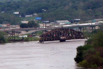
St. Joseph Swing Bridge, Railway bridge across Missouri River between St. Joseph, Missouri and Elwood, Kansas, United States.

The St. Joseph Swing Bridge is a railway crossing over the Missouri River connecting Missouri and Kansas, constructed from connected steel beams in a specialized design. The structure can swing open and closed to allow both river vessels and trains to pass through.

An original structure from 1873 was the first bridge at this location and served regional railroad traffic. The current structure was built in the early 1900s as a replacement to meet the growing demands of rail transport.

The bridge takes its name from the nearby city of St. Joseph and reflects the region's deep connection to railroad transport, which shaped economic life for generations. Today it stands as a visible link between two states and embodies the transportation heritage that communities here still recognize.

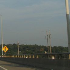
The best way to view the bridge is from the banks of the Missouri River, where the structure is clearly visible from multiple angles. The area has several vantage points where visitors can observe trains and watch the bridge operate.

The structure displays a distinctive pattern of diagonal steel bracing that was typical of bridges from this era and reflects the engineering approach of that time. This visible lattice work is one of the most recognizable features that visitors immediately notice when viewing the structure.

Location: Missouri

Location: Kansas

GPS coordinates: 39.75340,-94.85830

Latest update: December 14, 2025 12:25

Photos
Around this place
Jesse James Home Museum
United States of America

Jesse James Home Museum

1.2 km
Patee House
United States of America

Patee House

1.2 km
Pony Express Museum
United States of America

Pony Express Museum

875 m
Pony Express Bridge
United States of America

Pony Express Bridge

526 m
German-American Bank Building
United States of America

German-American Bank Building

1.5 km
St. Joseph Parkway
United States of America

St. Joseph Parkway

1.6 km
South Fourth Street Commercial Historic District
United States of America

South Fourth Street Commercial Historic District

1.2 km
Robidoux School
United States of America

Robidoux School

1.6 km
St. Joseph City Hall
United States of America

St. Joseph City Hall

2 km
Corby-Forsee Building
United States of America

Corby-Forsee Building

1.5 km
St. Joseph Public Library
United States of America

St. Joseph Public Library

1.7 km
Western Tablet and Stationery Company, Building No. 2
United States of America

Western Tablet and Stationery Company, Building No. 2

1.1 km
Buchanan County Courthouse
United States of America

Buchanan County Courthouse

1.6 km
Museum Hill Historic District
United States of America

Museum Hill Historic District

1.8 km
Missouri Valley Trust Company Historic District
United States of America

Missouri Valley Trust Company Historic District

1.5 km
Patee House
United States of America

Patee House

1.2 km
Burnside-Sandusky Gothic House
United States of America

Burnside-Sandusky Gothic House

1.2 km
Neely Elementary School
United States of America

Neely Elementary School

1.2 km
Wholesale Row Historic District
United States of America

Wholesale Row Historic District

1.6 km
Robidoux Hill Historic District
United States of America

Robidoux Hill Historic District

2.1 km
Virginia Flats
United States of America

Virginia Flats

2.1 km
Ryan Block
United States of America

Ryan Block

2.2 km
John D. Richardson Dry Goods Company
United States of America

John D. Richardson Dry Goods Company

1.7 km
Alois Herbert Double House
United States of America

Alois Herbert Double House

1.4 km
Wyeth Flats
United States of America

Wyeth Flats

2 km
Charles A. and Annie Buddy House
United States of America

Charles A. and Annie Buddy House

1.4 km
Central-North Commercial Historic District
United States of America

Central-North Commercial Historic District

1.6 km
Missouri Theatre
United States of America

Missouri Theatre

1.6 km
Show the full map
Reviews

Visited this place? Tap the stars to rate it and share your experience / photos with the community! Try now! You can cancel it anytime.

« St. Joseph Swing Bridge - Railway bridge across Missouri River between St. Joseph, Missouri and Elwood, Kansas, United States » is provided by Around Us (aroundus.com). Images and texts are derived from Wikimedia project under a Creative Commons license. You are allowed to copy, distribute, and modify copies of this page, under the conditions set by the license, as long as this note is clearly visible.

Discover hidden gems everywhere you go!

From secret cafés to breathtaking viewpoints, skip the crowded tourist spots and find places that match your style. Our app makes it easy with voice search, smart filtering, route optimization, and insider tips from travelers worldwide. Download now for the complete mobile experience.

Around Us App Screenshot

A unique approach to discovering new places

Le Figaro

All the places worth exploring

France Info

A tailor-made excursion in just a few clicks

20 Minutes