Enable Location

We need your location to show you interesting places around you

Discover nearby places

Find interesting locations and hidden gems around you

Precise directions

Get accurate directions and distances to places

Your location is never shared with other users. It's only used when you tap the location button.

Stillwater Bridge

Log in to your account

Start exploring — it's free

Trusted by 61,880 travelers worldwide

Continue with Google
Continue with Apple
or

We will send you a code to connect

By continuing, you accept our Terms and Conditions and our Privacy Policy

Check your inbox

We've sent a pincode in your inbox. Please enter the code below.

Stillwater Bridge

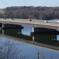
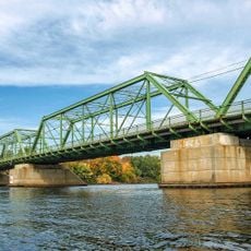
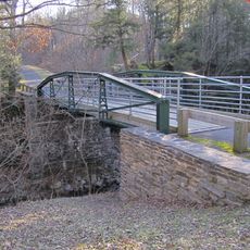
Stillwater Bridge, Truss bridge over Hudson River in Capital District, New York.

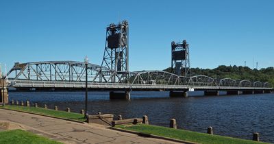
Stillwater Bridge is a truss bridge that crosses the Hudson River in the Capital District and connects Stillwater in Saratoga County to Schaghticoke in Rensselaer County. The structure has two traffic lanes and a pedestrian path on the south side, accommodating roughly 3,650 vehicles daily.

The structure was built in 1930 and replaced an earlier river crossing, marking a new era for transportation infrastructure in the Capital District. This development was part of broader improvements in the region that greatly enhanced mobility between counties.

The bridge links two communities and enables daily movement between people on opposite shores. It serves as a vital connection for commuters and visitors traveling between Saratoga and Rensselaer counties.

The bridge is accessible for vehicles and pedestrians during the day from both sides and connects easily. Visitors can walk or drive across, as the design provides space for both types of traffic.

The bridge provides access to Stillwater Island, situated between the Hudson River and Champlain Canal. The island holds Lock 4 State Canal Park, a place of historical importance for navigation and recreation.

The community of curious travelers

AroundUs brings together thousands of curated places, local tips, and hidden gems, enriched daily by 60,000 contributors worldwide.

Start exploring
Location
Inception
1930
Official opening
1930
GPS coordinates
42.93810,-73.65090
Latest update
December 14, 2025 16:40
Around this place
Boot Monument
United States of America

Boot Monument

7.9 km
Interstate 87
United States of America

Interstate 87

12.1 km
Yaddo
United States of America

Yaddo

16.9 km
Saratoga National Historical Park
United States of America

Saratoga National Historical Park

6.9 km
Moon's Lake House
United States of America

Moon's Lake House

14.6 km
Mechanicville Hydroelectric Plant
United States of America

Mechanicville Hydroelectric Plant

7.1 km
United States of America

Zim Smith trail

8.1 km
Urger
United States of America

Urger

16.1 km
Crescent Bridge
United States of America

Crescent Bridge

14.6 km
Troy–Waterford Bridge
United States of America

Troy–Waterford Bridge

16.7 km
Ruhle Road Stone Arch Bridge
United States of America

Ruhle Road Stone Arch Bridge

13.7 km
Oakcliff
United States of America

Oakcliff

14.2 km
Col. Elmer E. Ellsworth Monument and Grave
United States of America

Col. Elmer E. Ellsworth Monument and Grave

5.6 km
Clifton Park Center Baptist Church and Cemetery
United States of America

Clifton Park Center Baptist Church and Cemetery

17.2 km
Round Lake Library
United States of America

Round Lake Library

11.7 km
Enlarged Erie Canal Historic District
United States of America

Enlarged Erie Canal Historic District

10.1 km
Ruhle Road Lenticular Metal Truss Bridge
United States of America

Ruhle Road Lenticular Metal Truss Bridge

13.7 km
Waterford Village Historic District
United States of America

Waterford Village Historic District

16.6 km
Shenantaha Creek Park
United States of America

Shenantaha Creek Park

14.6 km
Wiggins-Collamer House
United States of America

Wiggins-Collamer House

13.1 km
All Saints Episcopal Church
United States of America

All Saints Episcopal Church

11.9 km
Noxon Bank Building
United States of America

Noxon Bank Building

14.4 km
Ormsby-Laughlin Textile Companies Mill
United States of America

Ormsby-Laughlin Textile Companies Mill

16.9 km
Tomhannock Methodist Episcopal Church
United States of America

Tomhannock Methodist Episcopal Church

11 km
Davis-Ferris Organ
United States of America

Davis-Ferris Organ

11.7 km
Stillwater Blockhouse
United States of America

Stillwater Blockhouse

452 m
Knickerbocker Mansion
United States of America

Knickerbocker Mansion

3.7 km
Round Lake Historic District
United States of America

Round Lake Historic District

11.7 km
Show the full map
« Stillwater Bridge - Truss bridge over Hudson River in Capital District, New York » is provided by Around Us (aroundus.com). Images and texts are derived from Wikimedia project under a Creative Commons license. You are allowed to copy, distribute, and modify copies of this page, under the conditions set by the license, as long as this note is clearly visible.

Discover hidden gems everywhere you go!

From secret cafés to breathtaking viewpoints, skip the crowded tourist spots and find places that match your style. Our app makes it easy with voice search, smart filtering, route optimization, and insider tips from travelers worldwide. Download now for the complete mobile experience.

Around Us App Screenshot

A unique approach to discovering new places

Le Figaro

All the places worth exploring

France Info

A tailor-made excursion in just a few clicks

20 Minutes

Around Us
Travel Guide & Maps
Download

Send to your phone

QR Code
1

Open the camera app on your mobile.

2

Point at the QR code with your camera. A notification will appear.

3

Tap the notification to open the link.