Enable Location

We need your location to show you interesting places around you

Discover nearby places

Find interesting locations and hidden gems around you

Precise directions

Get accurate directions and distances to places

Your location is never shared with other users. It's only used when you tap the location button.

Interstate 87

Log in to your account

Start exploring — it's free

Trusted by 63,103 travelers worldwide

Continue with Google
Continue with Apple
or

We will send you a code to connect

By continuing, you accept our Terms and Conditions and our Privacy Policy

Check your inbox

We've sent a pincode in your inbox. Please enter the code below.

Interstate 87
Discussion Reviews 2 Photos
47.5k Popularity

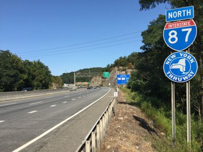
Interstate 87, Interstate highway in New York, US

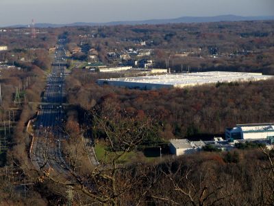
Interstate 87 is a major interstate highway that runs from New York City northward to the Canadian border, passing through diverse landscapes including the Hudson Valley and the Adirondack Mountains. The highway serves as a key transportation corridor with numerous exits connecting to cities, towns, and recreational areas along its entire length.

The highway was established in 1957 as part of the national Interstate Highway System development, reshaping transportation throughout the northeastern region. Over the decades, it became a vital corridor connecting major population centers with northern and rural areas.

The section north of Albany is known locally as Adirondack Veterans Memorial Highway, a designation that reflects the region's connection to military service and remembrance.

The highway is accessible year-round and provides direct access to cities, towns, and recreation areas across New York State. Winter conditions in the northern sections, particularly through the Adirondacks, may require extra caution and preparation for travelers.

At its northern terminus, the highway continues seamlessly into Quebec as Autoroute 15, creating a direct route between New York City and Montreal without interruption. This international connection makes it an unusual transportation corridor linking two countries.

The community of curious travelers

AroundUs brings together thousands of curated places, local tips, and hidden gems, enriched daily by 60,000 contributors worldwide.

Start exploring
Location
Inception
August 14, 1957
GPS coordinates
42.91621,-73.79599
Latest update
December 14, 2025 19:28
Around this place
Empire State Aerosciences Museum
United States of America

Empire State Aerosciences Museum

12.7 km
Mechanicville Hydroelectric Plant
United States of America

Mechanicville Hydroelectric Plant

10.4 km
United States of America

Zim Smith trail

4 km
Union Mill Complex
United States of America

Union Mill Complex

11.2 km
Brookside Museum
United States of America

Brookside Museum

10.7 km
Crescent Bridge
United States of America

Crescent Bridge

11.8 km
Verbeck House
United States of America

Verbeck House

10.3 km
Ruhle Road Stone Arch Bridge
United States of America

Ruhle Road Stone Arch Bridge

5 km
Stillwater Bridge
United States of America

Stillwater Bridge

12.1 km
Oakcliff
United States of America

Oakcliff

11.5 km
Col. Elmer E. Ellsworth Monument and Grave
United States of America

Col. Elmer E. Ellsworth Monument and Grave

8.7 km
Clifton Park Center Baptist Church and Cemetery
United States of America

Clifton Park Center Baptist Church and Cemetery

7.1 km
Round Lake Library
United States of America

Round Lake Library

2.3 km
Enlarged Erie Canal Historic District
United States of America

Enlarged Erie Canal Historic District

10.2 km
Ruhle Road Lenticular Metal Truss Bridge
United States of America

Ruhle Road Lenticular Metal Truss Bridge

5 km
Shenantaha Creek Park
United States of America

Shenantaha Creek Park

6.1 km
Grooms Tavern Complex
United States of America

Grooms Tavern Complex

9.9 km
Bridge 8, Erie Canal
United States of America

Bridge 8, Erie Canal

10.5 km
Nathan Garnsey House
United States of America

Nathan Garnsey House

7.8 km
Mohawk Valley Grange Hall
United States of America

Mohawk Valley Grange Hall

10 km
Cyrus Rexford House
United States of America

Cyrus Rexford House

10.2 km
Wiggins-Collamer House
United States of America

Wiggins-Collamer House

8.9 km
All Saints Episcopal Church
United States of America

All Saints Episcopal Church

2.6 km
Abraham Best House
United States of America

Abraham Best House

11.8 km
Noxon Bank Building
United States of America

Noxon Bank Building

11.5 km
Brown's Beach
United States of America

Brown's Beach

8.9 km
Davis-Ferris Organ
United States of America

Davis-Ferris Organ

2.3 km
Stillwater Blockhouse
United States of America

Stillwater Blockhouse

11.6 km
Show the full map
Reviews
Share your experience

No review yet

Discussions
Start a discussion...

No discussion yet

« Interstate 87 - Interstate highway in New York, US » is provided by Around Us (aroundus.com). Images and texts are derived from Wikimedia project under a Creative Commons license. You are allowed to copy, distribute, and modify copies of this page, under the conditions set by the license, as long as this note is clearly visible.

Discover hidden gems everywhere you go!

From secret cafés to breathtaking viewpoints, skip the crowded tourist spots and find places that match your style. Our app makes it easy with voice search, smart filtering, route optimization, and insider tips from travelers worldwide. Download now for the complete mobile experience.

Around Us App Screenshot

A unique approach to discovering new places

Le Figaro

All the places worth exploring

France Info

A tailor-made excursion in just a few clicks

20 Minutes

Around Us
Travel Guide & Maps
Download

Send to your phone

QR Code
1

Open the camera app on your mobile.

2

Point at the QR code with your camera. A notification will appear.

3

Tap the notification to open the link.