Enable Location

We need your location to show you interesting places around you

Discover nearby places

Find interesting locations and hidden gems around you

Precise directions

Get accurate directions and distances to places

Your location is never shared with other users. It's only used when you tap the location button.

Stockbridge Bowl

Log in to your account

Start exploring — it's free

Trusted by 62,441 travelers worldwide

Continue with Google
Continue with Apple
or

We will send you a code to connect

By continuing, you accept our Terms and Conditions and our Privacy Policy

Check your inbox

We've sent a pincode in your inbox. Please enter the code below.

Stockbridge Bowl

Stockbridge Bowl, artificially impounded body of water north of Stockbridge, Massachusetts

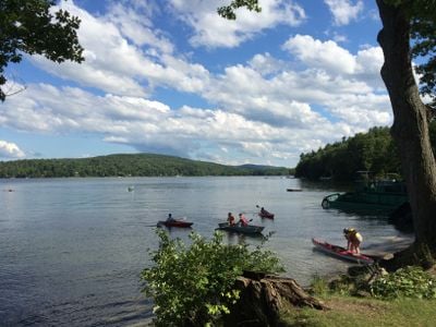
Stockbridge Bowl is a large reservoir in Massachusetts surrounded by green hills and forests in the Berkshire region. The body of water stretches roughly 2 miles long and reaches depths of about 48 feet, with a shoreline that curves around the landscape in an inviting way.

The lake was originally called Lake Mahkeenac, named after the Mahican people who inhabited the area and called it home of the Mahekanus. A dam was constructed in 1880 to manage water supply for the town, and the Stockbridge Bowl Association has overseen its care and environmental protection since 1946.

The lake is known locally as Lake Mahkeenac, a name rooted in the Mahican people who once inhabited the region. A historic sailing club on the western shore maintains a large wooden boathouse where members have gathered for generations, creating a strong sense of community tied to the water.

A public boat ramp on the northwest side provides easy water access, while a town beach on the southeast shore offers picnic areas and restrooms for day visitors. Multiple hiking trails circle the lake and through surrounding forests, ranging from easy family walks to more challenging routes through the hills.

A small island called Kwuniikwat was renamed in 2018 to honor the Stockbridge-Munsee tribe, with a name meaning appearing long in their language. The Josh Billings Run, a popular September triathlon where kayakers and canoeists paddle around the lake, draws many competitors and has become a cherished local tradition.

The community of curious travelers

AroundUs brings together thousands of curated places, local tips, and hidden gems, enriched daily by 60,000 contributors worldwide.

Start exploring
Location
Location
GPS coordinates
42.33528,-73.31861
Latest update
February 7, 2026 11:01
Around this place
Tanglewood
United States of America

Tanglewood

1.7 km
The Mount
United States of America

The Mount

3 km
Elm Court
United States of America

Elm Court

2.2 km
Norman Rockwell Museum
United States of America

Norman Rockwell Museum

5.5 km
Sedgwick Pie
United States of America

Sedgwick Pie

5.6 km
Naumkeag
United States of America

Naumkeag

5.1 km
Ventfort Hall Mansion and Gilded Age Museum
United States of America

Ventfort Hall Mansion and Gilded Age Museum

3.7 km
Shadow Brook Farm Historic District
United States of America

Shadow Brook Farm Historic District

1.3 km
Chesterwood
United States of America

Chesterwood

6.2 km
Mission House
United States of America

Mission House

5.8 km
Berkshire Theatre Festival
United States of America

Berkshire Theatre Festival

6.1 km
Berkshire Botanical Garden
United States of America

Berkshire Botanical Garden

4.2 km
Frelinghuysen Morris House and Studio
United States of America

Frelinghuysen Morris House and Studio

2.2 km
Lenox Library
United States of America

Lenox Library

3.7 km
Stockbridge Casino
United States of America

Stockbridge Casino

6.1 km
Merwin House (Stockbridge, Massachusetts)
United States of America

Merwin House (Stockbridge, Massachusetts)

5.9 km
Richmond Furnace Historical and Archeological District
United States of America

Richmond Furnace Historical and Archeological District

5.2 km
Congregational Church of West Stockbridge
United States of America

Congregational Church of West Stockbridge

3.9 km
West Stockbridge Town Hall
United States of America

West Stockbridge Town Hall

4 km
Glendale Power House
United States of America

Glendale Power House

6.7 km
Hyde House
United States of America

Hyde House

6.4 km
Citizens Hall
United States of America

Citizens Hall

2.4 km
West Stockbridge Grange No. 246
United States of America

West Stockbridge Grange No. 246

4.1 km
Elm-Maple-South Streets Historic District
United States of America

Elm-Maple-South Streets Historic District

6.2 km
Lenox Village Historic District
United States of America

Lenox Village Historic District

3.9 km
Turn Park Art Space
United States of America

Turn Park Art Space

4.2 km
Old Curtisville Historic District
United States of America

Old Curtisville Historic District

2.4 km
Main Street Historic District
United States of America

Main Street Historic District

5.9 km
Show the full map
« Stockbridge Bowl - artificially impounded body of water north of Stockbridge, Massachusetts » is provided by Around Us (aroundus.com). Images and texts are derived from Wikimedia project under a Creative Commons license. You are allowed to copy, distribute, and modify copies of this page, under the conditions set by the license, as long as this note is clearly visible.

Discover hidden gems everywhere you go!

From secret cafés to breathtaking viewpoints, skip the crowded tourist spots and find places that match your style. Our app makes it easy with voice search, smart filtering, route optimization, and insider tips from travelers worldwide. Download now for the complete mobile experience.

Around Us App Screenshot

A unique approach to discovering new places

Le Figaro

All the places worth exploring

France Info

A tailor-made excursion in just a few clicks

20 Minutes

Around Us
Travel Guide & Maps
Download

Send to your phone

QR Code
1

Open the camera app on your mobile.

2

Point at the QR code with your camera. A notification will appear.

3

Tap the notification to open the link.