·

Enable Location

We need your location to show you interesting places around you

Discover nearby places

Find interesting locations and hidden gems around you

Precise directions

Get accurate directions and distances to places

Your location is never shared with other users. It's only used when you tap the location button.

Stockbridge Indian Cemetery

Log in to your account

Start exploring — it's free

Trusted by 62,706 travelers worldwide

Continue with Google
Continue with Apple
or

We will send you a code to connect

By continuing, you accept our Terms and Conditions and our Privacy Policy

Check your inbox

We've sent a pincode in your inbox. Please enter the code below.

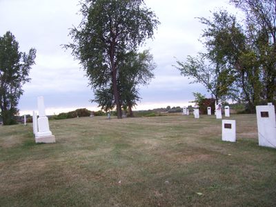
Stockbridge Indian Cemetery, cemetery in Stockbridge, Wisconsin, USA

Stockbridge Indian Cemetery is a burial ground in Stockbridge, Wisconsin, where members of the Stockbridge-Mohican community rest. The site contains between 150 and 200 graves marked by simple headstones, many weathered by time, with inscriptions of family names and dates from the 19th century onward.

The cemetery has served as a burial ground for the Stockbridge-Mohican community for generations, with graves dating back to the 19th century. The site reflects the long-standing presence of this Native American group in the region and their connection to the land.

The cemetery holds deep meaning for the Stockbridge-Mohican community, who consider it a sacred space for honoring their ancestors. Local descendants continue to visit and maintain a connection to the land, using it as a place for remembrance and cultural continuity.

The cemetery is accessible in a quiet setting surrounded by grass and trees, though it lacks active maintenance or gates. Visitors should approach with respect, remembering this is no longer an active burial ground, and note that many stones are covered with moss and weathered by age.

The cemetery was long neglected, but protested by the Stockbridge-Mohican community when nearby land began being used for pasture. This conflict underscores how the site remains central to indigenous identity and community efforts to reclaim and protect ancestral spaces.

The community of curious travelers

AroundUs brings together thousands of curated places, local tips, and hidden gems, enriched daily by 60,000 contributors worldwide.

Start exploring
Location
GPS coordinates
44.08222,-88.30083
Latest update
February 9, 2026 07:45
Around this place
High Cliff State Park
United States of America

High Cliff State Park

8.6 km
Menominee Park Zoo
United States of America

Menominee Park Zoo

18.7 km
Barlow Planetarium
United States of America

Barlow Planetarium

18.8 km
Neenah Light
United States of America

Neenah Light

16.1 km
Asylum Light
United States of America

Asylum Light

17.3 km
Ledge View Nature Center
United States of America

Ledge View Nature Center

14.7 km
Calumet County Courthouse
United States of America

Calumet County Courthouse

12.1 km
Havilah Babcock House
United States of America

Havilah Babcock House

16.2 km
George O. Bergstrom House
United States of America

George O. Bergstrom House

16.2 km
Richard Guenther House
United States of America

Richard Guenther House

19.1 km
Calumet Light
United States of America

Calumet Light

18.8 km
Franklyn C. Shattuck House
United States of America

Franklyn C. Shattuck House

16.2 km
St Thomas' Episcopal Church,
United States of America

St Thomas' Episcopal Church,

17.5 km
Henry Spencer Smith House
United States of America

Henry Spencer Smith House

16.8 km
Henry Sherry House
United States of America

Henry Sherry House

16.5 km
Charles R. Smith House
United States of America

Charles R. Smith House

16.7 km
Neenah United States Post Office
United States of America

Neenah United States Post Office

17.3 km
Judge J. C. Kerwin House
United States of America

Judge J. C. Kerwin House

16.9 km
Hiram Smith House
United States of America

Hiram Smith House

17.7 km
Edward D. & Vina Shattuck Beals House
United States of America

Edward D. & Vina Shattuck Beals House

16.6 km
Haese Memorial Village Historic District
United States of America

Haese Memorial Village Historic District

18.9 km
Ellis Jennings House
United States of America

Ellis Jennings House

16.8 km
Club Harbor
United States of America

Club Harbor

18.7 km
J. Leslie Sensenbrenner House
United States of America

J. Leslie Sensenbrenner House

16.2 km
Washington Park SplashPad
United States of America

Washington Park SplashPad

17.6 km
Classic Lanes Fox Valley
United States of America

Classic Lanes Fox Valley

17.5 km
George, Sr., and Ellen Banta House
United States of America

George, Sr., and Ellen Banta House

17.1 km
Perry Lindsley House
United States of America

Perry Lindsley House

16.7 km
Show the full map
« Stockbridge Indian Cemetery - cemetery in Stockbridge, Wisconsin, USA » is provided by Around Us (aroundus.com). Images and texts are derived from Wikimedia project under a Creative Commons license. You are allowed to copy, distribute, and modify copies of this page, under the conditions set by the license, as long as this note is clearly visible.

Discover hidden gems everywhere you go!

From secret cafés to breathtaking viewpoints, skip the crowded tourist spots and find places that match your style. Our app makes it easy with voice search, smart filtering, route optimization, and insider tips from travelers worldwide. Download now for the complete mobile experience.

Around Us App Screenshot

A unique approach to discovering new places

Le Figaro

All the places worth exploring

France Info

A tailor-made excursion in just a few clicks

20 Minutes

Around Us
Travel Guide & Maps
Download

Send to your phone

QR Code
1

Open the camera app on your mobile.

2

Point at the QR code with your camera. A notification will appear.

3

Tap the notification to open the link.