Sunkhaze Meadows National Wildlife Refuge

Log in to your account

AroundUs is a community-driven map of interesting places, built by curious explorers like you. It grows with every review, story, and photo you share.
Connect to save your favorite spots, contribute locations, and create personalized routes.
Continue with Google
Continue with Apple
Continue with X
Continue with Facebook
Continue with email
By continuing, you accept our Terms and Conditions and our Privacy Policy
Create an account

Sunkhaze Meadows National Wildlife Refuge

Add to collection
Map
Suggest a change
Share

Sunkhaze Meadows National Wildlife Refuge, National Wildlife Refuge in Milford, Maine, United States.

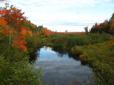
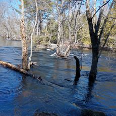
Sunkhaze Meadows is a large wildlife refuge in Maine that protects one of the state's largest peatland systems, spanning more than 11,400 acres. The landscape consists of raised bogs, open meadows, cedar swamps, and forest areas shaped by water and seasonal flooding.

The refuge was established in 1988 through federal conservation funding to protect the wetlands and forests of this region. Its creation reflected growing recognition of the value of peatland ecosystems in New England.

The wetland landscape here holds significance for local conservation efforts and nature education, drawing people who want to understand how these ecosystems function. Visitors often come to observe rare plants and birds that depend on this mosaic of waterways and peat formations.

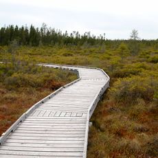
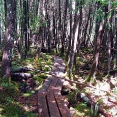
The area offers three marked walking trails open year-round with varying difficulty levels for different visitors. A free parking area on County Road serves as the main starting point for exploring the refuge.

The area is home to a dozen species listed as endangered by the state of Maine, including rare plants, specialized wetland birds, and invertebrates found nowhere else nearby. This concentration of rare species makes it a place of exceptional biological importance.

Location: Milford

Inception: 1988

Website: https://fws.gov/refuge/sunkhaze_meadows

GPS coordinates: 44.98000,-68.56000

Latest update: December 13, 2025 12:20

Photos
Around this place
Mount Hope Cemetery
United States of America

Mount Hope Cemetery

21.6 km
Bangor Public Library
United States of America

Bangor Public Library

25.7 km
United States of America

Black Cap Mountain

25.2 km
United States of America

Congregation Beth Israel

25.5 km
Penobscot River Bridge
United States of America

Penobscot River Bridge

25.7 km
St. Anne's Church and Mission Site
United States of America

St. Anne's Church and Mission Site

8.4 km
Fay Hyland Botanical Plantation
United States of America

Fay Hyland Botanical Plantation

13 km
Great Fire of 1911 Historic District
United States of America

Great Fire of 1911 Historic District

25.7 km
Orono Bog
United States of America

Orono Bog

18 km
Page Farm & Home Museum
United States of America

Page Farm & Home Museum

12.4 km
Hirundo Wildlife Refuge
United States of America

Hirundo Wildlife Refuge

17.8 km
Godfrey-Kellogg House
United States of America

Godfrey-Kellogg House

25.5 km
William Colburn House
United States of America

William Colburn House

13.8 km
Gov. Israel Washburn House
United States of America

Gov. Israel Washburn House

14.8 km
Connors House
United States of America

Connors House

25 km
Phi Gamma Delta House
United States of America

Phi Gamma Delta House

13.2 km
Jones P. Veazie House
United States of America

Jones P. Veazie House

25.3 km
Nathaniel Treat House
United States of America

Nathaniel Treat House

13.8 km
Edith Marion Patch House
United States of America

Edith Marion Patch House

12 km
Orono Post Office
United States of America

Orono Post Office

13.9 km
Morse & Co. Office Building
United States of America

Morse & Co. Office Building

25.7 km
Charles W. Jenkins House
United States of America

Charles W. Jenkins House

25.6 km
Charles G. Bryant Double House
United States of America

Charles G. Bryant Double House

25.6 km
Jonas Cutting–Edward Kent House
United States of America

Jonas Cutting–Edward Kent House

25.5 km
East Eddington Public Hall
United States of America

East Eddington Public Hall

21 km
Sargent-Roberts House
United States of America

Sargent-Roberts House

25.3 km
District No. 2 School
United States of America

District No. 2 School

23.2 km
Johnson Brook Trail
United States of America

Johnson Brook Trail

3.3 km
Show the full map
Reviews

Visited this place? Tap the stars to rate it and share your experience / photos with the community! Try now! You can cancel it anytime.

« Sunkhaze Meadows National Wildlife Refuge - National Wildlife Refuge in Milford, Maine, United States » is provided by Around Us (aroundus.com). Images and texts are derived from Wikimedia project under a Creative Commons license. You are allowed to copy, distribute, and modify copies of this page, under the conditions set by the license, as long as this note is clearly visible.

Discover hidden gems everywhere you go!

From secret cafés to breathtaking viewpoints, skip the crowded tourist spots and find places that match your style. Our app makes it easy with voice search, smart filtering, route optimization, and insider tips from travelers worldwide. Download now for the complete mobile experience.

Around Us App Screenshot

A unique approach to discovering new places

Le Figaro

All the places worth exploring

France Info

A tailor-made excursion in just a few clicks

20 Minutes