Enable Location

We need your location to show you interesting places around you

Discover nearby places

Find interesting locations and hidden gems around you

Precise directions

Get accurate directions and distances to places

Your location is never shared with other users. It's only used when you tap the location button.

Log in to your account

Start exploring — it's free

Trusted by 61,452 travelers worldwide

Continue with Google
Continue with Apple
or

We will send you a code to connect

By continuing, you accept our Terms and Conditions and our Privacy Policy

Check your inbox

We've sent a pincode in your inbox. Please enter the code below.

Stoddard Hill State Park

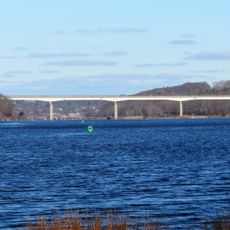
Stoddard Hill State Park, State park at Thames River in Ledyard, United States

Description

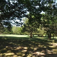
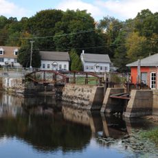
Stoddard Hill State Park is a 55-acre preserve along the eastern shore of the Thames River in Connecticut. The grounds include woodland trails, fishing areas, and boat launch facilities that provide access to water and forest recreation.

History

The state acquired this land in 1954 through a funding initiative that focused on creating public recreation areas. This acquisition was part of a broader effort to protect open spaces along Connecticut's river corridors.

Culture

The hill held significance for Native American communities who occupied the region and used its elevated position to observe their surroundings. Today, visitors can recognize this historical importance while walking through the wooded terrain.

Practical

The main entrance is located about five miles south of Norwich with parking and easy access to the main trails. Visitors should wear appropriate footwear for woodland paths and be prepared for varying terrain and seasonal conditions throughout the park.

Did you know?

A tidal estuary covering about five acres sits within the park and floods during high tide periods. This ecosystem draws people interested in observing birds and other wildlife that thrive in brackish water environments.

Location
Inception
1954
Elevation above the sea
27 m
GPS coordinates
41.46110,-72.06440
Latest update
December 14, 2025 18:45

AroundUs brings together thousands of curated places, local tips, and hidden gems, enriched daily by 60,000 contributors worldwide. Discover all places nearby (Connecticut).

Around this place
Mohegan Sun
United States of America

Mohegan Sun

4.1 km
Fort Shantok
United States of America

Fort Shantok

2.2 km
American Thermos Bottle Company Laurel Hill Plant
United States of America

American Thermos Bottle Company Laurel Hill Plant

5.6 km
Applewood Farm
United States of America

Applewood Farm

7.1 km
The Earth Tower
United States of America

The Earth Tower

4.2 km
Quaker Hill Historic District
United States of America

Quaker Hill Historic District

7.5 km
Norwich Town Hall
United States of America

Norwich Town Hall

7.4 km
Downtown Norwich Historic District
United States of America

Downtown Norwich Historic District

7.1 km
Nathan Lester House
United States of America

Nathan Lester House

4.3 km
Carroll Building
United States of America

Carroll Building

7.2 km
Gurdon Bill Store
United States of America

Gurdon Bill Store

4.2 km
John Fox Slater House
United States of America

John Fox Slater House

7.1 km
Laurel Hill Historic District
United States of America

Laurel Hill Historic District

6.4 km
Samson Occom Bridge
United States of America

Samson Occom Bridge

2.8 km
Jail Hill Historic District
United States of America

Jail Hill Historic District

7.5 km
Hallville Mill Historic District
United States of America

Hallville Mill Historic District

4.5 km
Capt. Mark Stoddard Farmstead
United States of America

Capt. Mark Stoddard Farmstead

2.9 km
Perkins-Bill House
United States of America

Perkins-Bill House

7.1 km
Shubel Smith House
United States of America

Shubel Smith House

7.8 km
Telephone Exchange Building
United States of America

Telephone Exchange Building

7.6 km
William A. Buckingham House
United States of America

William A. Buckingham House

7.1 km
Mohegan-Pequot Bridge
United States of America

Mohegan-Pequot Bridge

2.5 km
United States Post Office–Norwich Main
United States of America

United States Post Office–Norwich Main

7.1 km
David Chapman Farmstead
United States of America

David Chapman Farmstead

2.6 km
Lamb Homestead
United States of America

Lamb Homestead

7.5 km
Main Sawmill
United States of America

Main Sawmill

6.6 km
Little Plain Historic District
United States of America

Little Plain Historic District

7.4 km
Shetucket River Bridge
United States of America

Shetucket River Bridge

7 km
Show the full map
« Stoddard Hill State Park - State park at Thames River in Ledyard, United States » is provided by Around Us (aroundus.com). Images and texts are derived from Wikimedia project under a Creative Commons license. You are allowed to copy, distribute, and modify copies of this page, under the conditions set by the license, as long as this note is clearly visible.

Discover hidden gems everywhere you go!

From secret cafés to breathtaking viewpoints, skip the crowded tourist spots and find places that match your style. Our app makes it easy with voice search, smart filtering, route optimization, and insider tips from travelers worldwide. Download now for the complete mobile experience.

Around Us App Screenshot

A unique approach to discovering new places

Le Figaro

All the places worth exploring

France Info

A tailor-made excursion in just a few clicks

20 Minutes

Around Us
Travel Guide & Maps
Download

Send to your phone

QR Code
1

Open the camera app on your mobile.

2

Point at the QR code with your camera. A notification will appear.

3

Tap the notification to open the link.