Enable Location

We need your location to show you interesting places around you

Discover nearby places

Find interesting locations and hidden gems around you

Precise directions

Get accurate directions and distances to places

Your location is never shared with other users. It's only used when you tap the location button.

Stone Bridge

Log in to your account

Start exploring — it's free

Trusted by 66,488 travelers worldwide

Continue with Google
Continue with Apple
or

We will send you a code to connect

By continuing, you accept our Terms and Conditions and our Privacy Policy

Check your inbox

We've sent a pincode in your inbox. Please enter the code below.

Stone Bridge
Discussion Reviews 1 Photos
5.8k Popularity

Stone Bridge, Railway bridge in Johnstown, United States

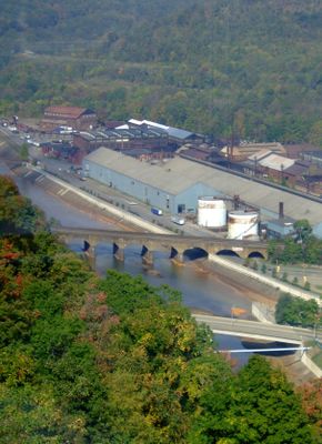
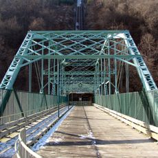
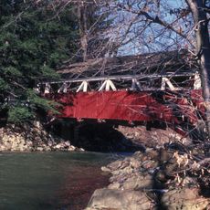
Stone Bridge is a railway bridge in Johnstown, Pennsylvania, spanning the Conemaugh River on seven stone arches. It carries four active railway tracks used by Norfolk Southern Railway for regular freight operations.

The bridge was built by the Pennsylvania Railroad in 1887 and 1888, just a year before the catastrophic Johnstown Flood of 1889 swept through the valley. Debris carried by the floodwaters piled up against the arches and caught fire, yet the structure held.

The bridge sits at the heart of Johnstown and is part of the everyday backdrop for people who live nearby. Its stone arches have become so familiar that locals rarely stop to look, yet visitors often pause at the riverbank to take in the scale of the structure.

The bridge is in active railway use, so the tracks themselves are off limits to visitors. The best views of the stone arches are from the riverbank nearby, where you can see the full span without any obstruction.

Stone Bridge is one of the few remaining skewed stone arch bridges in the country, meaning its arches cross the river at an angle rather than straight across. This type of construction was already uncommon for stone bridges of this size even when it was built.

The community of curious travelers

AroundUs brings together thousands of curated places, local tips, and hidden gems, enriched daily by 60,000 contributors worldwide.

Start exploring
Location
Made from material
rock
GPS coordinates
40.33250,-78.92490
Latest update
March 3, 2026 22:41
Around this place
Johnstown Inclined Plane
United States of America

Johnstown Inclined Plane

835 m
Ghost Town Trail
United States of America

Ghost Town Trail

16.9 km
Johnstown Flood National Memorial
United States of America

Johnstown Flood National Memorial

12.5 km
Cambria Iron Company
United States of America

Cambria Iron Company

422 m
Staple Bend Tunnel
United States of America

Staple Bend Tunnel

6.6 km
Johnstown Flood Museum
United States of America

Johnstown Flood Museum

628 m
Cathedral of Saint John Gualbert
United States of America

Cathedral of Saint John Gualbert

1.1 km
Inclined Plane Bridge
United States of America

Inclined Plane Bridge

750 m
Buttermilk Falls Natural Area
United States of America

Buttermilk Falls Natural Area

15.5 km
Moxham Historic District
United States of America

Moxham Historic District

4.1 km
Cambria City Historic District
United States of America

Cambria City Historic District

1 km
Downtown Johnstown Historic District
United States of America

Downtown Johnstown Historic District

991 m
Windber Historic District
United States of America

Windber Historic District

13.3 km
Old Conemaugh Borough Historic District
United States of America

Old Conemaugh Borough Historic District

1.3 km
Minersville Historic District
United States of America

Minersville Historic District

1.2 km
Laurel Hill Furnace
United States of America

Laurel Hill Furnace

12 km
Shaffer's Bridge
United States of America

Shaffer's Bridge

6.6 km
Grand Army of the Republic Hall
United States of America

Grand Army of the Republic Hall

889 m
Alma Hall
United States of America

Alma Hall

980 m
Westmont Historic District
United States of America

Westmont Historic District

1.6 km
Johnstown Flood National Memorial
United States of America

Johnstown Flood National Memorial

13.2 km
Ross Furnace
United States of America

Ross Furnace

14.1 km
Unger House
United States of America

Unger House

13.2 km
Heritage Discovery Center
United States of America

Heritage Discovery Center

989 m
Christ the Saviour Orthodox Cathedral (Johnstown, Pennsylvania)
United States of America

Christ the Saviour Orthodox Cathedral (Johnstown, Pennsylvania)

2.6 km
South Fork Fishing and Hunting Club Clubhouse
United States of America

South Fork Fishing and Hunting Club Clubhouse

13 km
Pasquerilla Performing Arts Center
United States of America

Pasquerilla Performing Arts Center

10.5 km
Lake View Visitor Center
United States of America

Lake View Visitor Center

13.2 km
Show the full map
Reviews
Share your experience

No review yet

Discussions
Start a discussion...

No discussion yet

« Stone Bridge - Railway bridge in Johnstown, United States » is provided by Around Us (aroundus.com). Images and texts are derived from Wikimedia project under a Creative Commons license. You are allowed to copy, distribute, and modify copies of this page, under the conditions set by the license, as long as this note is clearly visible.

Discover hidden gems everywhere you go!

From secret cafés to breathtaking viewpoints, skip the crowded tourist spots and find places that match your style. Our app makes it easy with voice search, smart filtering, route optimization, and insider tips from travelers worldwide. Download now for the complete mobile experience.

Around Us App Screenshot

A unique approach to discovering new places

Le Figaro

All the places worth exploring

France Info

A tailor-made excursion in just a few clicks

20 Minutes

Around Us
Travel Guide & Maps
Download

Send to your phone

QR Code
1

Open the camera app on your mobile.

2

Point at the QR code with your camera. A notification will appear.

3

Tap the notification to open the link.