Tinkers Creek Aqueduct

Log in to your account

AroundUs is a community-driven map of interesting places, built by curious explorers like you. It grows with every review, story, and photo you share.
Connect to save your favorite spots, contribute locations, and create personalized routes.
By continuing, you accept our Terms and Conditions and our Privacy Policy
Add to collection
Map
Suggest a change
Share

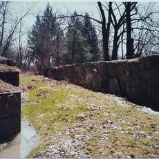
Tinkers Creek Aqueduct, Navigable aqueduct in Cuyahoga County, United States

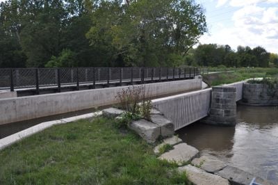
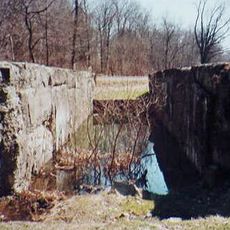
Tinkers Creek Aqueduct is a stone structure that crosses over a stream to carry the Ohio and Erie Canal above the water. It consists of several large stone arches joined together to form a wide bridge that allows canal boats to pass through.

The structure was built in 1827 and became an important link as the canal economy grew. After flooding damaged it multiple times, it was repaired and rebuilt to ensure it would last.

The structure shows how canal builders in the 1800s adapted Roman building methods to carry water over obstacles. Visitors can see this practical use of ancient techniques when they look at the stone arches that still support the canal's weight today.

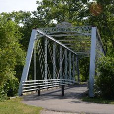
The best way to reach it is through the Towpath Trail, a path that runs parallel to the canal. The area is easy to explore on foot, and a nearby visitor center offers information and a good starting point.

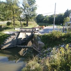
It is the only aqueduct surviving from the original group of four built in the Cuyahoga Valley during the canal era. This loss of other structures makes it a rare example of the canal building period.

Location: Cuyahoga County

Official opening: 1827

GPS coordinates: 41.36481,-81.60877

Latest update: December 13, 2025 11:47

Photos
Around this place
Ohio and Erie Canal
United States of America

Ohio and Erie Canal

1.5 km
Valley View Bridge
United States of America

Valley View Bridge

5.3 km
St. Josaphat's Ukrainian Catholic Cathedral
United States of America

St. Josaphat's Ukrainian Catholic Cathedral

9.7 km
Brecksville-Northfield High Level Bridge
United States of America

Brecksville-Northfield High Level Bridge

5.2 km
Brecksville Reservation
United States of America

Brecksville Reservation

6 km
Jaite Mill Historic District
United States of America

Jaite Mill Historic District

9.7 km
Cathedral of St. John the Baptist
United States of America

Cathedral of St. John the Baptist

8.3 km
Station Road Bridge
United States of America

Station Road Bridge

5.4 km
Independence Slab
United States of America

Independence Slab

3.4 km
St. Michael Byzantine Catholic Church Toledo
United States of America

St. Michael Byzantine Catholic Church Toledo

8.3 km
Edmund Gleason Farm
United States of America

Edmund Gleason Farm

316 m
Bedford Baptist Church
United States of America

Bedford Baptist Church

6.8 km
Independence Presbyterian Church
United States of America

Independence Presbyterian Church

3.3 km
St. Joseph Convent and Academy Complex
United States of America

St. Joseph Convent and Academy Complex

6.2 km
Wilson Feed Mill
United States of America

Wilson Feed Mill

1.4 km
William Knapp House
United States of America

William Knapp House

902 m
Coonrad Ranger Station
United States of America

Coonrad Ranger Station

9.9 km
Abraham Ulyatt House
United States of America

Abraham Ulyatt House

2.5 km
Lock Tender's House and Inn
United States of America

Lock Tender's House and Inn

939 m
Charles B. Rich House
United States of America

Charles B. Rich House

6.6 km
South Park Site
United States of America

South Park Site

1.9 km
Terra Vista Archeological District
United States of America

Terra Vista Archeological District

412 m
Vaughn Site
United States of America

Vaughn Site

9 km
Lock No. 35
United States of America

Lock No. 35

1.3 km
Stephen Frazee House
United States of America

Stephen Frazee House

1.9 km
Lock No. 34
United States of America

Lock No. 34

9.2 km
Miles Park Historic District
United States of America

Miles Park Historic District

9.1 km
Bedford Historic Business District
United States of America

Bedford Historic Business District

6.8 km
Show the full map
Reviews

Visited this place? Tap the stars to rate it and share your experience / photos with the community! Try now! You can cancel it anytime.

« Tinkers Creek Aqueduct - Navigable aqueduct in Cuyahoga County, United States » is provided by Around Us (aroundus.com). Images and texts are derived from Wikimedia project under a Creative Commons license. You are allowed to copy, distribute, and modify copies of this page, under the conditions set by the license, as long as this note is clearly visible.

Discover hidden gems everywhere you go!

From secret cafés to breathtaking viewpoints, skip the crowded tourist spots and find places that match your style. Our app makes it easy with voice search, smart filtering, route optimization, and insider tips from travelers worldwide. Download now for the complete mobile experience.

Around Us App Screenshot

A unique approach to discovering new places

Le Figaro

All the places worth exploring

France Info

A tailor-made excursion in just a few clicks

20 Minutes