Enable Location

We need your location to show you interesting places around you

Discover nearby places

Find interesting locations and hidden gems around you

Precise directions

Get accurate directions and distances to places

Your location is never shared with other users. It's only used when you tap the location button.

Log in to your account

Start exploring — it's free

Trusted by 62,050 travelers worldwide

Continue with Google
Continue with Apple
or

We will send you a code to connect

By continuing, you accept our Terms and Conditions and our Privacy Policy

Check your inbox

We've sent a pincode in your inbox. Please enter the code below.

Turnbull Creek Educational State Forest

Turnbull Creek Educational State Forest, Educational forest in Bladen County, North Carolina, United States.

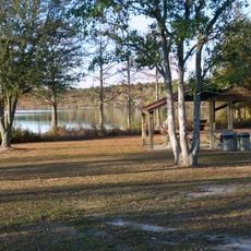
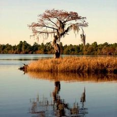
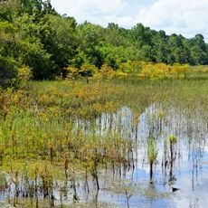
Turnbull Creek Educational State Forest is a protected area in Bladen County with several walking trails through wetlands and hardwood forests. The grounds support many animal species and plant communities that benefit from the wet environment.

The forest was created to give schools and organizations a place for hands-on environmental education. It is part of North Carolina's efforts to develop natural learning spaces focused on forest protection and management.

School groups and organizations use this place for outdoor learning, where environmental topics are taught directly in nature. The trails have information signs that help visitors understand the connections between forest, water, and wildlife.

The grounds have marked trails and parking for visitors of different ability levels. Guided tours for school groups are available, and the trails are usually accessible year-round.

The forest functions as a monitoring station where scientists track ecosystem changes and the effects of shifting climate patterns. This data helps conservation staff understand how the forest changes over time.

The community of curious travelers

AroundUs brings together thousands of curated places, local tips, and hidden gems, enriched daily by 60,000 contributors worldwide.

Start exploring
GPS coordinates
34.68361,-78.58306
Latest update
December 14, 2025 16:45
Around this place
Jones Lake State Park
United States of America

Jones Lake State Park

6 km
Singletary Lake State Park
United States of America

Singletary Lake State Park

14.8 km
Harmony Hall
United States of America

Harmony Hall

16.1 km
Lake Waccamaw State Park
United States of America

Lake Waccamaw State Park

48.4 km
Oakland Plantation
United States of America

Oakland Plantation

29.3 km
Cape Fear Botanical Garden
United States of America

Cape Fear Botanical Garden

48.3 km
Columbus County Courthouse
United States of America

Columbus County Courthouse

40.1 km
Mt. Horeb Presbyterian Church and Cemetery
United States of America

Mt. Horeb Presbyterian Church and Cemetery

22.2 km
Baker Sanatorium
United States of America

Baker Sanatorium

39.3 km
John Hector Clark House
United States of America

John Hector Clark House

22.7 km
Carolina Civic Center
United States of America

Carolina Civic Center

39.6 km
Big Rockfish Presbyterian Church
United States of America

Big Rockfish Presbyterian Church

43.2 km
Black River Presbyterian and Ivanhoe Baptist Churches
United States of America

Black River Presbyterian and Ivanhoe Baptist Churches

32.6 km
Luther Henry Caldwell House
United States of America

Luther Henry Caldwell House

39.8 km
Robeson County Agricultural Building
United States of America

Robeson County Agricultural Building

39.6 km
Black Rock Plantation House
United States of America

Black Rock Plantation House

47.9 km
Maxwell House
United States of America

Maxwell House

39.8 km
Cape Fear Baptist Church
United States of America

Cape Fear Baptist Church

33.3 km
Hope Mills Historic District
United States of America

Hope Mills Historic District

46.1 km
Robeson Planetarium and Science Center
United States of America

Robeson Planetarium and Science Center

44.1 km
Alfred Rowland House
United States of America

Alfred Rowland House

40.2 km
Gen. Thomas Boykin House
United States of America

Gen. Thomas Boykin House

36.4 km
Planters Building
United States of America

Planters Building

39.6 km
Graves-Stewart House
United States of America

Graves-Stewart House

42 km
W.R. Surles Memorial Library
United States of America

W.R. Surles Memorial Library

47.6 km
Robert Herring House
United States of America

Robert Herring House

42.5 km
Francis Pugh House
United States of America

Francis Pugh House

44.4 km
United States of America

Trinity Methodist Church

6.5 km
Show the full map
« Turnbull Creek Educational State Forest - Educational forest in Bladen County, North Carolina, United States » is provided by Around Us (aroundus.com). Images and texts are derived from Wikimedia project under a Creative Commons license. You are allowed to copy, distribute, and modify copies of this page, under the conditions set by the license, as long as this note is clearly visible.

Discover hidden gems everywhere you go!

From secret cafés to breathtaking viewpoints, skip the crowded tourist spots and find places that match your style. Our app makes it easy with voice search, smart filtering, route optimization, and insider tips from travelers worldwide. Download now for the complete mobile experience.

Around Us App Screenshot

A unique approach to discovering new places

Le Figaro

All the places worth exploring

France Info

A tailor-made excursion in just a few clicks

20 Minutes

Around Us
Travel Guide & Maps
Download

Send to your phone

QR Code
1

Open the camera app on your mobile.

2

Point at the QR code with your camera. A notification will appear.

3

Tap the notification to open the link.