Enable Location

We need your location to show you interesting places around you

Discover nearby places

Find interesting locations and hidden gems around you

Precise directions

Get accurate directions and distances to places

Your location is never shared with other users. It's only used when you tap the location button.

Baker Sanatorium

Log in to your account

Start exploring — it's free

Trusted by 63,732 travelers worldwide

Continue with Google
Continue with Apple
or

We will send you a code to connect

By continuing, you accept our Terms and Conditions and our Privacy Policy

Check your inbox

We've sent a pincode in your inbox. Please enter the code below.

Discussion Reviews 1 Photos
1.2k Popularity

Baker Sanatorium, hospital in North Carolina, United States

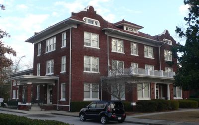
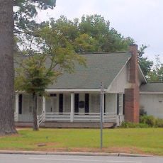
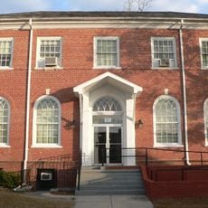
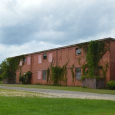
Baker Sanatorium is a former hospital in Lumberton, North Carolina, listed on the National Register of Historic Places. The brick building features Mission Revival architecture with a T-shaped layout, five front sections, and an arcaded porch with decorative arches typical of the style.

Built in 1920-1921 by architect Roger C. McCarl, the sanatorium was designed to provide medical care to the region. It later merged with Thompson Hospital and became part of what is now Southeastern Regional Medical Center in 1953.

The name comes from Dr. Horace M. Baker, who opened this facility in 1921 and brought medical services to the area. The arcaded porch and terra cotta tiles reflect Mission Revival style inspired by Spanish missions, showing how architectural choices shaped early 20th-century healthcare spaces in the South.

The site is easily accessible at the corner of 14th and Chestnut Street in Lumberton, where it is visible from a distance. The building's architectural details can be seen from the street, making it straightforward to explore the exterior.

Dr. Horace M. Baker Jr., descended from the founder, was a skilled surgeon who also played violin and performed regularly at church services. His dedication to both medicine and music made him a memorable figure in the community's medical history.

The community of curious travelers

AroundUs brings together thousands of curated places, local tips, and hidden gems, enriched daily by 60,000 contributors worldwide.

Start exploring
Location
GPS coordinates
34.62720,-79.00690
Latest update
February 9, 2026 07:45
Around this place
South of the Border
United States of America

South of the Border

31.3 km
Jones Lake State Park
United States of America

Jones Lake State Park

34.6 km
Lumber River State Park
United States of America

Lumber River State Park

26.3 km
Flora MacDonald College
United States of America

Flora MacDonald College

21.9 km
Harmony Hall
United States of America

Harmony Hall

26.8 km
Gimghoul Neighborhood Historic District
United States of America

Gimghoul Neighborhood Historic District

32 km
United States of America

Philadelphus Presbyterian Church

22 km
Old Main
United States of America

Old Main

19 km
John Hector Clark House
United States of America

John Hector Clark House

35.8 km
Carolina Civic Center
United States of America

Carolina Civic Center

900 m
Rocky Ridge Farm Historic District
United States of America

Rocky Ridge Farm Historic District

31.2 km
Big Rockfish Presbyterian Church
United States of America

Big Rockfish Presbyterian Church

36.9 km
Luther Henry Caldwell House
United States of America

Luther Henry Caldwell House

634 m
Ashpole Presbyterian Church
United States of America

Ashpole Presbyterian Church

29.1 km
Dr. Evan Alexander Erwin House
United States of America

Dr. Evan Alexander Erwin House

35.6 km
Robeson County Agricultural Building
United States of America

Robeson County Agricultural Building

533 m
Centenary Methodist Church
United States of America

Centenary Methodist Church

27 km
Hamer Hall
United States of America

Hamer Hall

33.2 km
Cape Fear Baptist Church
United States of America

Cape Fear Baptist Church

35.1 km
Robeson Planetarium and Science Center
United States of America

Robeson Planetarium and Science Center

4.8 km
Alfred Rowland House
United States of America

Alfred Rowland House

1 km
Planters Building
United States of America

Planters Building

928 m
Maxton Historic District
United States of America

Maxton Historic District

33.7 km
Rowland Main Street Historic District
United States of America

Rowland Main Street Historic District

28.1 km
W.R. Surles Memorial Library
United States of America

W.R. Surles Memorial Library

17 km
United States of America

Trinity Methodist Church

37 km
Bladen County Training School
United States of America

Bladen County Training School

35.6 km
Givens Performing Arts Center
United States of America

Givens Performing Arts Center

19 km
Show the full map
Reviews
Share your experience

No review yet

Discussions
Start a discussion...

No discussion yet

« Baker Sanatorium - hospital in North Carolina, United States » is provided by Around Us (aroundus.com). Images and texts are derived from Wikimedia project under a Creative Commons license. You are allowed to copy, distribute, and modify copies of this page, under the conditions set by the license, as long as this note is clearly visible.

Discover hidden gems everywhere you go!

From secret cafés to breathtaking viewpoints, skip the crowded tourist spots and find places that match your style. Our app makes it easy with voice search, smart filtering, route optimization, and insider tips from travelers worldwide. Download now for the complete mobile experience.

Around Us App Screenshot

A unique approach to discovering new places

Le Figaro

All the places worth exploring

France Info

A tailor-made excursion in just a few clicks

20 Minutes

Around Us
Travel Guide & Maps
Download

Send to your phone

QR Code
1

Open the camera app on your mobile.

2

Point at the QR code with your camera. A notification will appear.

3

Tap the notification to open the link.