Upper Mississippi River National Wildlife and Fish Refuge

Log in to your account

AroundUs is a community-driven map of interesting places, built by curious explorers like you. It grows with every review, story, and photo you share.
Connect to save your favorite spots, contribute locations, and create personalized routes.
By continuing, you accept our Terms and Conditions and our Privacy Policy

Upper Mississippi River National Wildlife and Fish Refuge

Add to collection
Map
Suggest a change
Share

Upper Mississippi River National Wildlife and Fish Refuge, Wildlife and fish refuge along Mississippi River in Minnesota, Wisconsin, Iowa and Illinois, United States.

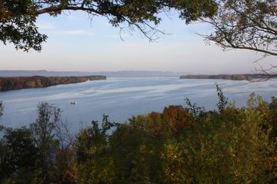
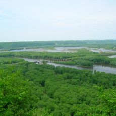
The Upper Mississippi River National Wildlife and Fish Refuge covers a vast river valley with steep wooded bluffs and flat water areas alongside the main channel. The terrain includes forests, marshes, and lakes spread across multiple states along the river corridor.

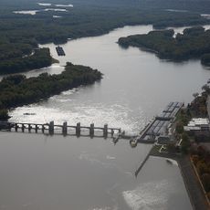
The refuge was established in 1924 to protect migratory bird species and their habitats when wetland destruction was a major threat. Dams and locks were built later to control water levels and create more habitat for wildlife.

The refuge provides essential stopover grounds for migrating birds traveling between northern and southern regions each season. Visitors often see large flocks of ducks and geese gathering on the water, especially during fall and spring movements.

Visitors can fish, hunt, hike, or boat throughout the refuge, though options vary by season and specific areas. It helps to check ahead about which activities are allowed during your visit and which sections open for different purposes.

The refuge was established in 1924 specifically to protect migratory birds rather than for general wildlife conservation, setting its original mission apart. This focus on traveling species still shapes how it is managed today and draws birdwatchers from around the world.

Location: Wisconsin

Location: Illinois

Location: Iowa

Location: Minnesota

Website: https://fws.gov/refuge/upper_mississippi_river

GPS coordinates: 42.88330,-91.10000

Latest update: December 8, 2025 20:01

Photos
Around this place
Show the full map
Pikes Peak State Park
United States of America

Pikes Peak State Park

13.7 km
Wyalusing State Park
United States of America

Wyalusing State Park

10.8 km
American House
United States of America

American House

17 km
Lock and Dam No. 10
United States of America

Lock and Dam No. 10

11 km
Stonefield
United States of America

Stonefield

17.8 km
St. Mary's Catholic Church
United States of America

St. Mary's Catholic Church

11.4 km
Peter Stauer House
United States of America

Peter Stauer House

16.5 km
Lakeside Ballroom
United States of America

Lakeside Ballroom

9.3 km
St. Peters United Evangelical Lutheran Church
United States of America

St. Peters United Evangelical Lutheran Church

9.8 km
Clayton School
United States of America

Clayton School

4.3 km
Old Rock School
United States of America

Old Rock School

17.1 km
Matt-Bahls House
United States of America

Matt-Bahls House

11.5 km
Albertus Building
United States of America

Albertus Building

11 km
Goedert Meat Market
United States of America

Goedert Meat Market

16.8 km
Joseph "Diamond Jo" Reynolds Office Building and House
United States of America

Joseph "Diamond Jo" Reynolds Office Building and House

16.9 km
First Congregational Church
United States of America

First Congregational Church

11.4 km
Guttenberg National Fish Hatchery and Aquarium Historic District
United States of America

Guttenberg National Fish Hatchery and Aquarium Historic District

11.2 km
Parker House
United States of America

Parker House

12.1 km
James Ballantine House
United States of America

James Ballantine House

14.2 km
Front Street Historic District
United States of America

Front Street Historic District

11.3 km
McGregor Commercial Historic District
United States of America

McGregor Commercial Historic District

16.8 km
Wehmer House
United States of America

Wehmer House

12.9 km
Fuerste House
United States of America

Fuerste House

11.3 km
I.O.O.F. Hall
United States of America

I.O.O.F. Hall

11.2 km
Guttenberg Corn Canning Co.
United States of America

Guttenberg Corn Canning Co.

10.4 km
Weber House
United States of America

Weber House

11.8 km
Guttenberg State Bank
United States of America

Guttenberg State Bank

11.2 km
Kolker House
United States of America

Kolker House

11.2 km
Show the full map
Reviews

Visited this place? Tap the stars to rate it and share your experience / photos with the community! Try now! You can cancel it anytime.

« Upper Mississippi River National Wildlife and Fish Refuge - Wildlife and fish refuge along Mississippi River in Minnesota, Wisconsin, Iowa and Illinois, United States » is provided by Around Us (aroundus.com). Images and texts are derived from Wikimedia project under a Creative Commons license. You are allowed to copy, distribute, and modify copies of this page, under the conditions set by the license, as long as this note is clearly visible.

Discover hidden gems everywhere you go!

From secret cafés to breathtaking viewpoints, skip the crowded tourist spots and find places that match your style. Our app makes it easy with voice search, smart filtering, route optimization, and insider tips from travelers worldwide. Download now for the complete mobile experience.

Around Us App Screenshot

A unique approach to discovering new places

Le Figaro

All the places worth exploring

France Info

A tailor-made excursion in just a few clicks

20 Minutes