Enable Location

We need your location to show you interesting places around you

Discover nearby places

Find interesting locations and hidden gems around you

Precise directions

Get accurate directions and distances to places

Your location is never shared with other users. It's only used when you tap the location button.

Upper Black Eddy – Milford Bridge

Log in to your account

Start exploring — it's free

Trusted by 61,908 travelers worldwide

Continue with Google
Continue with Apple
or

We will send you a code to connect

By continuing, you accept our Terms and Conditions and our Privacy Policy

Check your inbox

We've sent a pincode in your inbox. Please enter the code below.

Upper Black Eddy – Milford Bridge

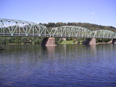
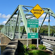
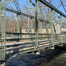
Upper Black Eddy – Milford Bridge, Steel truss bridge across Delaware River between Upper Black Eddy, Pennsylvania and Milford, New Jersey.

The Upper Black Eddy-Milford Bridge is a steel truss structure crossing the Delaware River between Pennsylvania and New Jersey, featuring a polygonal Warren through truss design connected with rivets. The roadway provides two lanes of traffic linking the two states across the waterway.

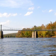
The bridge was constructed in 1933 by the McClintic-Marshall Company of Pittsburgh, replacing a wooden toll structure from 1842 that had served the region for nearly a century. This steel replacement marked a shift toward modern materials and toll-free regional connectivity.

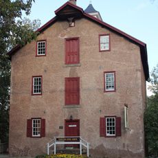
The structure serves as a tangible link between two separate river communities, with 19th-century residences visible along the Pennsylvania shoreline on both sides. Travelers cross this span to move between distinct local identities and lifestyles.

The structure operates under a 55-ton weight limit, so drivers should verify vehicle suitability before crossing. The toll-free passage connects two state routes and flows regularly throughout the day.

The bridge was submerged under 7 feet (2 meters) of floodwaters during 1955 hurricanes but emerged structurally sound, demonstrating unexpected durability. Few travelers realize this span has endured one of the region's most severe weather events.

The community of curious travelers

AroundUs brings together thousands of curated places, local tips, and hidden gems, enriched daily by 60,000 contributors worldwide.

Start exploring
Location
Location
GPS coordinates
40.56640,-75.09860
Latest update
December 14, 2025 14:24
Around this place
Delaware Canal State Park
United States of America

Delaware Canal State Park

2.1 km
Riegelsville Bridge
United States of America

Riegelsville Bridge

8.4 km
Hunterdon Plateau
United States of America

Hunterdon Plateau

3.7 km
Uhlerstown–Frenchtown Bridge
United States of America

Uhlerstown–Frenchtown Bridge

5.3 km
Volendam Windmill
United States of America

Volendam Windmill

6.5 km
Ringing Rocks County Park
United States of America

Ringing Rocks County Park

2.4 km
Mount Salem Vineyards
United States of America

Mount Salem Vineyards

9.8 km
Lower Delaware National Wild and Scenic River
United States of America

Lower Delaware National Wild and Scenic River

7.6 km
United States of America

Villa Milagro Vineyards

8.1 km
Benjamin Riegel House
United States of America

Benjamin Riegel House

8.5 km
Old Stone Church
United States of America

Old Stone Church

8.3 km
Isaac Stover House
United States of America

Isaac Stover House

8.1 km
Stover Mill
United States of America

Stover Mill

8.2 km
Erwinna Covered Bridge
United States of America

Erwinna Covered Bridge

7.4 km
Thatcher House
United States of America

Thatcher House

7.1 km
Case Farmstead
United States of America

Case Farmstead

9.4 km
Hixson–Mixsell House
United States of America

Hixson–Mixsell House

10 km
George Hunt House
United States of America

George Hunt House

7.9 km
Pursley's Ferry Historic District
United States of America

Pursley's Ferry Historic District

7.9 km
Seigle Homestead
United States of America

Seigle Homestead

7.6 km
Mount Joy Road Bridge
United States of America

Mount Joy Road Bridge

7.5 km
Frenchtown Historic District
United States of America

Frenchtown Historic District

5.3 km
Ringing Rocks County Park
United States of America

Ringing Rocks County Park

2.4 km
Finesville–Seigletown Historic District
United States of America

Finesville–Seigletown Historic District

7.5 km
Amsterdam Historic District
United States of America

Amsterdam Historic District

5.7 km
Uhlerstown Covered Bridge
United States of America

Uhlerstown Covered Bridge

5 km
Mount Pleasant Historic District
United States of America

Mount Pleasant Historic District

4.3 km
Little York Historic District
United States of America

Little York Historic District

5.5 km
Show the full map
« Upper Black Eddy – Milford Bridge - Steel truss bridge across Delaware River between Upper Black Eddy, Pennsylvania and Milford, New Jersey » is provided by Around Us (aroundus.com). Images and texts are derived from Wikimedia project under a Creative Commons license. You are allowed to copy, distribute, and modify copies of this page, under the conditions set by the license, as long as this note is clearly visible.

Discover hidden gems everywhere you go!

From secret cafés to breathtaking viewpoints, skip the crowded tourist spots and find places that match your style. Our app makes it easy with voice search, smart filtering, route optimization, and insider tips from travelers worldwide. Download now for the complete mobile experience.

Around Us App Screenshot

A unique approach to discovering new places

Le Figaro

All the places worth exploring

France Info

A tailor-made excursion in just a few clicks

20 Minutes

Around Us
Travel Guide & Maps
Download

Send to your phone

QR Code
1

Open the camera app on your mobile.

2

Point at the QR code with your camera. A notification will appear.

3

Tap the notification to open the link.