Walkersville Covered Bridge

Log in to your account

AroundUs is a community-driven map of interesting places, built by curious explorers like you. It grows with every review, story, and photo you share.
Connect to save your favorite spots, contribute locations, and create personalized routes.
By continuing, you accept our Terms and Conditions and our Privacy Policy
Add to collection
Map
Suggest a change
Share

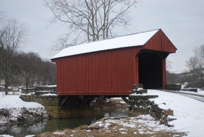
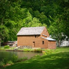
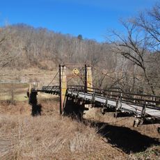
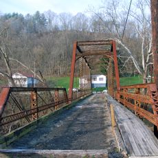
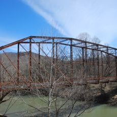
Walkersville Covered Bridge, Covered bridge in Lewis County, United States.

The Walkersville Covered Bridge measures 39 feet long and 12 feet wide, featuring red board-and-batten siding and a metal roof over the West Fork River.

Built in 1903 by architect John G. Sprigg, the Queen post truss bridge represents the engineering methods and transportation requirements of rural West Virginia communities.

The structure maintains its position on the National Register of Historic Places since 1981, representing the architectural techniques of early American bridge construction.

Located on County Route 19/17 near U.S. Route 19, the bridge stands at coordinates 38°51′30″N 80°27′39″W, offering access to historical architecture enthusiasts.

The timber frame construction incorporates specific design elements of the Queenpost Truss style, spanning the right fork of the West Fork River.

Location: Lewis County

Inception: 1902

GPS coordinates: 38.85830,-80.46080

Latest update: November 28, 2025 14:29

Around this place
Show the full map
Holly River State Park
United States of America

Holly River State Park

24.3 km
West Virginia State Wildlife Center
United States of America

West Virginia State Wildlife Center

13 km
Jackson's Mill
United States of America

Jackson's Mill

26.5 km
Burnsville Lake
United States of America

Burnsville Lake

13.8 km
Jackson's Mill State 4-H Camp Historic District
United States of America

Jackson's Mill State 4-H Camp Historic District

26.8 km
William Post Mansion
United States of America

William Post Mansion

25.4 km
Weston Colored School
United States of America

Weston Colored School

20.2 km
Helvetia Village Historic District
United States of America

Helvetia Village Historic District

28.1 km
Cunningham House and Outbuildings
United States of America

Cunningham House and Outbuildings

11.4 km
Weston Downtown Historic District
United States of America

Weston Downtown Historic District

19.9 km
Duck Run Cable Suspension Bridge
United States of America

Duck Run Cable Suspension Bridge

29.3 km
Downtown Buckhannon Historic District
United States of America

Downtown Buckhannon Historic District

25.1 km
Agnes Howard Hall
United States of America

Agnes Howard Hall

25.4 km
William Edgar Haymond House
United States of America

William Edgar Haymond House

30.5 km
Jonathan M. Bennett House
United States of America

Jonathan M. Bennett House

19.8 km
Mollohan Mill
United States of America

Mollohan Mill

19.7 km
Weston Downtown Residential Historic District
United States of America

Weston Downtown Residential Historic District

20.5 km
Fidler's Mill
United States of America

Fidler's Mill

21 km
Burnsville Bridge
United States of America

Burnsville Bridge

17 km
Sutton Downtown Historic District
United States of America

Sutton Downtown Historic District

30.4 km
Southern Methodist Church Building
United States of America

Southern Methodist Church Building

24.8 km
Stouts Mill Bridge
United States of America

Stouts Mill Bridge

23.9 km
French Creek Presbyterian Church
United States of America

French Creek Presbyterian Church

14.1 km
Buckhannon Central Residential Historical District
United States of America

Buckhannon Central Residential Historical District

25.2 km
Flatwoods Monster Museum
United States of America

Flatwoods Monster Museum

30.5 km
Museum of American Glass in West Virginia
United States of America

Museum of American Glass in West Virginia

20.1 km
Kanawha Theater
United States of America

Kanawha Theater

24.9 km
New Deal Resources in Holly River State Park Historic District
United States of America

New Deal Resources in Holly River State Park Historic District

23.1 km
Show the full map

Reviews

Visited this place? Tap the stars to rate it and share your experience / photos with the community! Try now! You can cancel it anytime.

« Walkersville Covered Bridge: Covered bridge in Lewis County, United States » is provided by Around Us (aroundus.com). Images and texts are derived from Wikimedia project under a Creative Commons license. You are allowed to copy, distribute, and modify copies of this page, under the conditions set by the license, as long as this note is clearly visible.

Discover hidden gems everywhere you go!

From secret cafés to breathtaking viewpoints, skip the crowded tourist spots and find places that match your style. Our app makes it easy with voice search, smart filtering, route optimization, and insider tips from travelers worldwide. Download now for the complete mobile experience.

Around Us App Screenshot

A unique approach to discovering new places

Le Figaro

All the places worth exploring

France Info

A tailor-made excursion in just a few clicks

20 Minutes