Framingham Reservoir No. 1 Dam and Gatehouse

Log in to your account

AroundUs is a community-driven map of interesting places, built by curious explorers like you. It grows with every review, story, and photo you share.
Connect to save your favorite spots, contribute locations, and create personalized routes.
Continue with Google
Continue with Apple
Continue with X
Continue with Facebook
Continue with email
By continuing, you accept our Terms and Conditions and our Privacy Policy
Create an account
Add to collection
Map
Suggest a change
Share

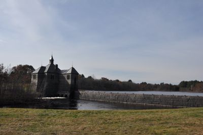
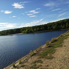
Framingham Reservoir No. 1 Dam and Gatehouse, Historic water control facility in Framingham, United States

Framingham Reservoir No. 1 Dam is an earthen embankment with a granite core that holds back a large body of water across the Sudbury area. The gatehouse next to the dam contained mechanical controls and connections to direct water through pipes to other parts of the water supply network.

The dam was built in the late 1870s as part of Boston's plan to expand its water supply system to growing communities nearby. Soon after completion, officials realized the water stored here had quality issues and changed how they used this particular reservoir.

The stone gatehouse reflects the care taken in designing water infrastructure, with its solid construction and traditional architectural details that still mark the landscape today. Its presence shows how communities once invested in permanent structures to manage resources they depended on.

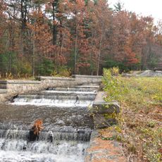
The dam area is protected but can be viewed from accessible pathways in the surrounding landscape, and photography is typically permitted from public access areas. The site offers good views from ground level where visitors can see the full span of the structure across the valley.

The reservoir was taken out of active service within a few years because muddy sediment at its bottom discolored the water and made it unsuitable for public use. This early failure taught engineers important lessons about water storage that shaped decisions about other reservoirs in the region.

Location: Massachusetts

Architects: George Albert Clough

GPS coordinates: 42.29167,-71.44278

Latest update: December 14, 2025 13:07

Photos
Around this place
New England Compounding Center meningitis outbreak
United States of America

New England Compounding Center meningitis outbreak

2.4 km
Garden in the Woods
United States of America

Garden in the Woods

5.7 km
Sri Lakshmi Temple
United States of America

Sri Lakshmi Temple

2.6 km
Callahan State Park
United States of America

Callahan State Park

3.7 km
Cochituate State Park
United States of America

Cochituate State Park

6.1 km
Ashland State Park
United States of America

Ashland State Park

5.9 km
Nobscot Hill
United States of America

Nobscot Hill

6.1 km
Danforth Museum
United States of America

Danforth Museum

2.3 km
Stone's Bridge
United States of America

Stone's Bridge

6.6 km
First Baptist Church
United States of America

First Baptist Church

1 km
Framingham Centre Common Historic District
United States of America

Framingham Centre Common Historic District

1.5 km
Sudbury Dam Historic District
United States of America

Sudbury Dam Historic District

4.3 km
Concord Square Historic District
United States of America

Concord Square Historic District

2.5 km
Saxonville Historic District
United States of America

Saxonville Historic District

5 km
Paul Gibbs House
United States of America

Paul Gibbs House

5.3 km
Ashland Town House
United States of America

Ashland Town House

3.9 km
Moses Ellis House
United States of America

Moses Ellis House

1.5 km
Stephen Bacon House
United States of America

Stephen Bacon House

7.1 km
Isaac Bullard House
United States of America

Isaac Bullard House

7.1 km
Irving Square Historic District
United States of America

Irving Square Historic District

2.8 km
Sawin-Bullen-Bullard House
United States of America

Sawin-Bullen-Bullard House

5 km
Eleazer Goulding House
United States of America

Eleazer Goulding House

6.4 km
Charles D. Lewis House
United States of America

Charles D. Lewis House

6.8 km
Joseph Cleale House
United States of America

Joseph Cleale House

6.6 km
Bullen-Stratton-Cozzen House
United States of America

Bullen-Stratton-Cozzen House

5.4 km
Boston Paint Ball
United States of America

Boston Paint Ball

4.5 km
Memorial Beach
United States of America

Memorial Beach

6.9 km
Hopkinton Reservoir Beach
United States of America

Hopkinton Reservoir Beach

7.1 km
Show the full map
Reviews

Visited this place? Tap the stars to rate it and share your experience / photos with the community! Try now! You can cancel it anytime.

« Framingham Reservoir No. 1 Dam and Gatehouse - Historic water control facility in Framingham, United States » is provided by Around Us (aroundus.com). Images and texts are derived from Wikimedia project under a Creative Commons license. You are allowed to copy, distribute, and modify copies of this page, under the conditions set by the license, as long as this note is clearly visible.

Discover hidden gems everywhere you go!

From secret cafés to breathtaking viewpoints, skip the crowded tourist spots and find places that match your style. Our app makes it easy with voice search, smart filtering, route optimization, and insider tips from travelers worldwide. Download now for the complete mobile experience.

Around Us App Screenshot

A unique approach to discovering new places

Le Figaro

All the places worth exploring

France Info

A tailor-made excursion in just a few clicks

20 Minutes