Enable Location

We need your location to show you interesting places around you

Discover nearby places

Find interesting locations and hidden gems around you

Precise directions

Get accurate directions and distances to places

Your location is never shared with other users. It's only used when you tap the location button.

Nobscot Hill

Log in to your account

Start exploring — it's free

Trusted by 65,016 travelers worldwide

Continue with Google
Continue with Apple
or

We will send you a code to connect

By continuing, you accept our Terms and Conditions and our Privacy Policy

Check your inbox

We've sent a pincode in your inbox. Please enter the code below.

Nobscot Hill
Discussion Reviews 1 Photos
3.2k Popularity

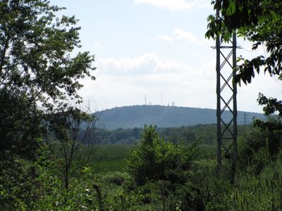
Nobscot Hill, Mountain summit in Framingham, United States.

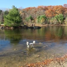
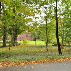
Nobscot Hill is a forested summit located within a reservation near Framingham, Massachusetts, surrounded by wetlands and open meadows. Several named trails, including the Tower, White Ridge, Fire, and Ellis Land routes, lead through the area and up to the top.

The Nipmuc people named and used this hill as a lookout long before European settlement. In the 1850s, writer Henry David Thoreau passed through the area during his travels across Massachusetts.

The name Nobscot comes from the Nipmuc language and refers to a natural feature of the land. At the top, a stone cairn marks the spot where the Nipmuc once used the hill as a lookout point.

The summit can be reached by several trails with different levels of difficulty, so it helps to check the route before setting out. Spring through fall tends to offer the most walkable conditions on the paths.

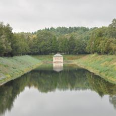
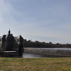
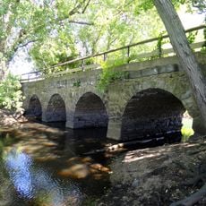
Henry Ford began building a dam at the base of the hill in the 1930s, but the project was never finished. The remains of that structure are still visible today and tend to surprise visitors who come across them on the trail.

The community of curious travelers

AroundUs brings together thousands of curated places, local tips, and hidden gems, enriched daily by 60,000 contributors worldwide.

Start exploring
Location
GPS coordinates
42.34593,-71.44923
Latest update
March 3, 2026 13:57
Around this place
Lincoln-Sudbury Regional High School
United States of America

Lincoln-Sudbury Regional High School

7 km
American Heritage Museum
United States of America

American Heritage Museum

7.8 km
Wayside Inn Historic District
United States of America

Wayside Inn Historic District

2 km
Garden in the Woods
United States of America

Garden in the Woods

1.9 km
Assabet River National Wildlife Refuge
United States of America

Assabet River National Wildlife Refuge

7.2 km
Callahan State Park
United States of America

Callahan State Park

3.3 km
Weston Aqueduct
United States of America

Weston Aqueduct

6.2 km
Danforth Museum
United States of America

Danforth Museum

7.6 km
Framingham Reservoir No. 1 Dam and Gatehouse
United States of America

Framingham Reservoir No. 1 Dam and Gatehouse

6.1 km
Goodnow Library
United States of America

Goodnow Library

3.3 km
Sudbury Center Historic District
United States of America

Sudbury Center Historic District

5.4 km
Stone's Bridge
United States of America

Stone's Bridge

4.5 km
First Baptist Church
United States of America

First Baptist Church

5.1 km
Old Town Bridge
United States of America

Old Town Bridge

6.5 km
Framingham Centre Common Historic District
United States of America

Framingham Centre Common Historic District

4.8 km
Sudbury Dam Historic District
United States of America

Sudbury Dam Historic District

5.7 km
Goodale Homestead
United States of America

Goodale Homestead

5.8 km
Concord Square Historic District
United States of America

Concord Square Historic District

7.9 km
Saxonville Historic District
United States of America

Saxonville Historic District

4.6 km
Paul Gibbs House
United States of America

Paul Gibbs House

3.1 km
Noyes-Parris House
United States of America

Noyes-Parris House

7.2 km
Hopestill Bent Tavern
United States of America

Hopestill Bent Tavern

6.5 km
Moses Ellis House
United States of America

Moses Ellis House

4.6 km
American Heritage Museum
United States of America

American Heritage Museum

6.8 km
Moses Brewer House
United States of America

Moses Brewer House

3.7 km
Bogle-Walker House
United States of America

Bogle-Walker House

4.5 km
Wayland Center Historic District
United States of America

Wayland Center Historic District

7.6 km
Southborough Center Historic District
United States of America

Southborough Center Historic District

7.9 km
Show the full map
Reviews
Share your experience

No review yet

Discussions
Start a discussion...

No discussion yet

« Nobscot Hill - Mountain summit in Framingham, United States » is provided by Around Us (aroundus.com). Images and texts are derived from Wikimedia project under a Creative Commons license. You are allowed to copy, distribute, and modify copies of this page, under the conditions set by the license, as long as this note is clearly visible.

Discover hidden gems everywhere you go!

From secret cafés to breathtaking viewpoints, skip the crowded tourist spots and find places that match your style. Our app makes it easy with voice search, smart filtering, route optimization, and insider tips from travelers worldwide. Download now for the complete mobile experience.

Around Us App Screenshot

A unique approach to discovering new places

Le Figaro

All the places worth exploring

France Info

A tailor-made excursion in just a few clicks

20 Minutes

Around Us
Travel Guide & Maps
Download

Send to your phone

QR Code
1

Open the camera app on your mobile.

2

Point at the QR code with your camera. A notification will appear.

3

Tap the notification to open the link.