Enable Location

We need your location to show you interesting places around you

Discover nearby places

Find interesting locations and hidden gems around you

Precise directions

Get accurate directions and distances to places

Your location is never shared with other users. It's only used when you tap the location button.

Holter Dam

Log in to your account

Start exploring — it's free

Trusted by 61,965 travelers worldwide

Continue with Google
Continue with Apple
or

We will send you a code to connect

By continuing, you accept our Terms and Conditions and our Privacy Policy

Check your inbox

We've sent a pincode in your inbox. Please enter the code below.

Holter Dam

Holter Dam, Gravity dam in Lewis and Clark County, United States

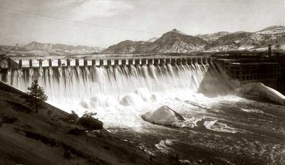
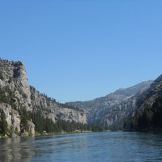
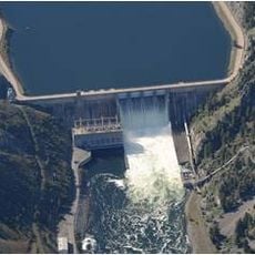
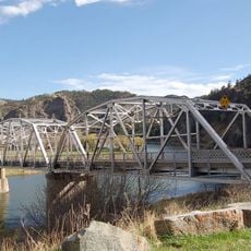
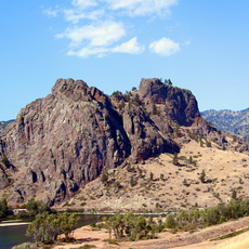
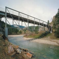
Holter Dam is a gravity dam on the Missouri River in Montana, approximately 415 meters long and 38 meters high. The structure backs up water to form Holter Lake, a large reservoir that stretches across the valley.

Construction of the dam began in 1908 by the United Missouri River Power Company and Montana Power Company under Samuel Thomas Hauser's direction. Its completion in 1916 provided reliable power to the growing region.

The facility displays early hydroelectric architecture built in the early 1900s, with stone structures and industrial buildings that shape the landscape. Visitors can see how the installation fits into the Missouri River valley and continues to influence daily life in the region today.

The site is accessible year-round, with summer being the best time when weather is stable. Visitors should wear sturdy shoes since paths around the facility can be uneven and sun exposure is strong.

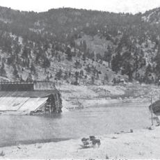
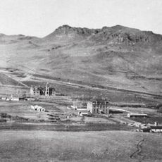
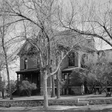
During construction in 1916, the site housed a massive work camp with over 100 buildings. This camp sheltered hundreds of workers in dormitories and even operated its own hospital and dining facility.

The community of curious travelers

AroundUs brings together thousands of curated places, local tips, and hidden gems, enriched daily by 60,000 contributors worldwide.

Start exploring
GPS coordinates
46.99170,-112.00600
Latest update
December 9, 2025 18:41
Around this place
Cathedral of Saint Helena
United States of America

Cathedral of Saint Helena

44.8 km
Hauser Dam
United States of America

Hauser Dam

26.8 km
Gates of the Mountains Wilderness
United States of America

Gates of the Mountains Wilderness

12.4 km
Canyon Ferry Dam
United States of America

Canyon Ferry Dam

43.7 km
St. Peter's Mission Church and Cemetery
United States of America

St. Peter's Mission Church and Cemetery

35 km
Confederate Memorial Fountain
United States of America

Confederate Memorial Fountain

44.4 km
Temple Emanu-El
United States of America

Temple Emanu-El

44.8 km
Hardy Bridge
United States of America

Hardy Bridge

23.5 km
Tower Rock State Park
United States of America

Tower Rock State Park

26.5 km
Helena Montana Temple
United States of America

Helena Montana Temple

39.8 km
Helena Civic Center
United States of America

Helena Civic Center

44.2 km
Black Sandy State Park
United States of America

Black Sandy State Park

28.8 km
Dearborn River High Bridge
United States of America

Dearborn River High Bridge

43.4 km
Hauser Mansion
United States of America

Hauser Mansion

44.2 km
Lewis and Clark County Hospital Historic District
United States of America

Lewis and Clark County Hospital Historic District

41.2 km
Porter Flats Apartments
United States of America

Porter Flats Apartments

45 km
Olsen House
United States of America

Olsen House

44.5 km
Silver King Ranch
United States of America

Silver King Ranch

43.1 km
Morris Silverman House
United States of America

Morris Silverman House

44.9 km
Great Northern Carousel
United States of America

Great Northern Carousel

43.9 km
Robert and Elizabeth Fisk House
United States of America

Robert and Elizabeth Fisk House

45 km
Young Women's Christian Association
United States of America

Young Women's Christian Association

44 km
Montana Veterans and Pioneers Memorial Building
United States of America

Montana Veterans and Pioneers Memorial Building

45.1 km
Mann Gulch Wildfire Historic District
United States of America

Mann Gulch Wildfire Historic District

14.5 km
Wick-Seiler House
United States of America

Wick-Seiler House

44.8 km
St John's Lutheran Church (Helena)
United States of America

St John's Lutheran Church (Helena)

44.1 km
Former Montana Executive Mansion
United States of America

Former Montana Executive Mansion

45 km
Craig Bridge
United States of America

Craig Bridge

9.8 km
Show the full map
« Holter Dam - Gravity dam in Lewis and Clark County, United States » is provided by Around Us (aroundus.com). Images and texts are derived from Wikimedia project under a Creative Commons license. You are allowed to copy, distribute, and modify copies of this page, under the conditions set by the license, as long as this note is clearly visible.

Discover hidden gems everywhere you go!

From secret cafés to breathtaking viewpoints, skip the crowded tourist spots and find places that match your style. Our app makes it easy with voice search, smart filtering, route optimization, and insider tips from travelers worldwide. Download now for the complete mobile experience.

Around Us App Screenshot

A unique approach to discovering new places

Le Figaro

All the places worth exploring

France Info

A tailor-made excursion in just a few clicks

20 Minutes

Around Us
Travel Guide & Maps
Download

Send to your phone

QR Code
1

Open the camera app on your mobile.

2

Point at the QR code with your camera. A notification will appear.

3

Tap the notification to open the link.