Bagnell Dam

Log in to your account

AroundUs is a community-driven map of interesting places, built by curious explorers like you. It grows with every review, story, and photo you share.
Connect to save your favorite spots, contribute locations, and create personalized routes.
Continue with Google
Continue with Apple
Continue with X
Continue with Facebook
Continue with email
By continuing, you accept our Terms and Conditions and our Privacy Policy
Create an account
Add to collection
Map
Suggest a change
Share

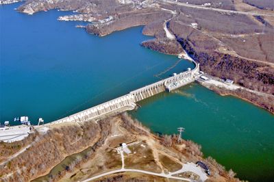
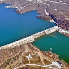
Bagnell Dam, Hydroelectric power station in Miller County, United States.

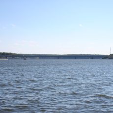
Bagnell Dam is a dam across the Osage River in Miller County, impounding the Lake of the Ozarks with its highly branched shores. The structure houses eight turbines within a long powerhouse built of concrete, generating electricity through the flow of water.

Construction started in 1929 when a private company financed the project during the economic depression and employed thousands of workers. Completion in 1931 created one of the largest man-made bodies of water of that era and permanently altered the landscape of central Missouri.

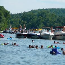
The construction transformed a sparsely settled river valley into one of the Midwest's most frequented leisure regions, now drawing visitors from many states. Towns along the branching shoreline developed shapes and identities shaped largely by the reservoir, and the flow of guests continues to define their character today.

The crest of the structure is open to foot traffic and offers views of the water on both sides as well as the turbine hall below the crown. On sunny days a walk in early morning or late afternoon proves rewarding, when fewer visitors are present and the light is more favorable.

A control room at this location remotely operates a pumped storage facility some distance away, coordinating power generation across multiple installations simultaneously. This central monitoring allows the grid to balance demand peaks more flexibly and to use generating capacity more efficiently.

Location: Miller County

Elevation above the sea: 197 m

Length: 775 m

GPS coordinates: 38.20444,-92.62306

Latest update: December 17, 2025 11:10

Photos
Around this place
Lake of the Ozarks
United States of America

Lake of the Ozarks

126 m
Party Cove
United States of America

Party Cove

11.8 km
Ha Ha Tonka State Park
United States of America

Ha Ha Tonka State Park

28.8 km
Lake of the Ozarks State Park
United States of America

Lake of the Ozarks State Park

11.8 km
Grand Glaize Bridge
United States of America

Grand Glaize Bridge

8.1 km
Bridal Cave
United States of America

Bridal Cave

21.9 km
Cathedral of Saint Joseph
United States of America

Cathedral of Saint Joseph

56.2 km
508th Missile Squadron
United States of America

508th Missile Squadron

47.6 km
Old Stagecoach Stop
United States of America

Old Stagecoach Stop

55.8 km
Calloway Manes Homestead
United States of America

Calloway Manes Homestead

41 km
Fiery Fork Conservation Area
United States of America

Fiery Fork Conservation Area

31.9 km
Big Surf Waterpark
United States of America

Big Surf Waterpark

16.2 km
Zion Lutheran Church
United States of America

Zion Lutheran Church

49.1 km
Morgan County Courthouse
United States of America

Morgan County Courthouse

32.3 km
Villa Panorama
United States of America

Villa Panorama

55.3 km
Finke Opera House
United States of America

Finke Opera House

48.2 km
Moreau Park Historic District
United States of America

Moreau Park Historic District

54 km
Pulaski County Courthouse
United States of America

Pulaski County Courthouse

55.8 km
Gray-Wood Buildings
United States of America

Gray-Wood Buildings

48.5 km
Moniteau County Courthouse Square
United States of America

Moniteau County Courthouse Square

48.4 km
Lewis and Elizabeth Bolton House
United States of America

Lewis and Elizabeth Bolton House

48.1 km
Oscar G. and Mary H. Burch House
United States of America

Oscar G. and Mary H. Burch House

56.2 km
Moreau Drive Historic District
United States of America

Moreau Drive Historic District

55.5 km
Dulle Farmstead Historic District
United States of America

Dulle Farmstead Historic District

55.5 km
Nelson C. and Gertrude A. Burch House
United States of America

Nelson C. and Gertrude A. Burch House

56.2 km
Joseph and Elizabeth Wallendorf House
United States of America

Joseph and Elizabeth Wallendorf House

52.6 km
Eldon Aquatic Center
United States of America

Eldon Aquatic Center

17.3 km
Camden County Historical Society
United States of America

Camden County Historical Society

20.5 km
Show the full map
Reviews

Visited this place? Tap the stars to rate it and share your experience / photos with the community! Try now! You can cancel it anytime.

« Bagnell Dam - Hydroelectric power station in Miller County, United States » is provided by Around Us (aroundus.com). Images and texts are derived from Wikimedia project under a Creative Commons license. You are allowed to copy, distribute, and modify copies of this page, under the conditions set by the license, as long as this note is clearly visible.

Discover hidden gems everywhere you go!

From secret cafés to breathtaking viewpoints, skip the crowded tourist spots and find places that match your style. Our app makes it easy with voice search, smart filtering, route optimization, and insider tips from travelers worldwide. Download now for the complete mobile experience.

Around Us App Screenshot

A unique approach to discovering new places

Le Figaro

All the places worth exploring

France Info

A tailor-made excursion in just a few clicks

20 Minutes