·

Enable Location

We need your location to show you interesting places around you

Discover nearby places

Find interesting locations and hidden gems around you

Precise directions

Get accurate directions and distances to places

Your location is never shared with other users. It's only used when you tap the location button.

Sugarloaf Mound

Log in to your account

Start exploring — it's free

Trusted by 62,647 travelers worldwide

Continue with Google
Continue with Apple
or

We will send you a code to connect

By continuing, you accept our Terms and Conditions and our Privacy Policy

Check your inbox

We've sent a pincode in your inbox. Please enter the code below.

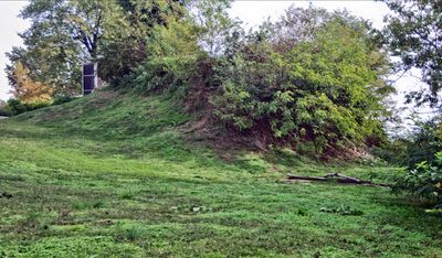
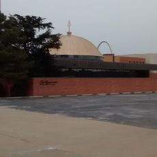
Sugarloaf Mound, Native American tumulus in St. Louis, United States.

Sugarloaf Mound is an earthen structure built by indigenous peoples centuries ago in downtown St. Louis. The mound rises approximately 40 feet (12 meters) tall and spans about 100 feet (30 meters) from north to south, positioned near the river's edge.

The mound was built between 600 and 1300 AD and remains the last surviving example of about 40 similar structures that once dotted the St. Louis landscape. Its survival tells the story of indigenous occupation long before European settlement arrived.

The mound held sacred meaning for the indigenous peoples who built it and served as a gathering place for ceremonies and spiritual practices. Its presence shaped how communities understood their relationship to the land and river.

The site is challenging to navigate due to uneven ground and dense vegetation covering the mound's surface. Visiting during daytime and arriving with prior research or a guide helps you get the most from the visit.

The mound served as a survey landmark when the city was officially incorporated in 1809, helping surveyors map out the growing settlement. This practical function meant it played an active role in shaping how the city expanded and took form.

The community of curious travelers

AroundUs brings together thousands of curated places, local tips, and hidden gems, enriched daily by 60,000 contributors worldwide.

Start exploring
Location
GPS coordinates
38.57490,-90.23100
Latest update
December 8, 2025 19:54
Around this place
Lemp Mansion
United States of America

Lemp Mansion

2.4 km
Missouri Botanical Garden
United States of America

Missouri Botanical Garden

5 km
Anheuser-Busch Brewery
United States of America

Anheuser-Busch Brewery

3 km
Climatron
United States of America

Climatron

5 km
Thomas F. Eagleton United States Courthouse
United States of America

Thomas F. Eagleton United States Courthouse

6.4 km
Tower Grove Park
United States of America

Tower Grove Park

4.1 km
MacArthur Bridge
United States of America

MacArthur Bridge

6.1 km
Compton Hill Reservoir Park
United States of America

Compton Hill Reservoir Park

4.4 km
Chatillon-DeMenil House
United States of America

Chatillon-DeMenil House

2.4 km
Eugene Field House
United States of America

Eugene Field House

6.1 km
Pevely Dairy Company Plant
United States of America

Pevely Dairy Company Plant

5.7 km
St. Louis Limestone
United States of America

St. Louis Limestone

5 km
Church of the Holy Family
United States of America

Church of the Holy Family

3.7 km
Immaculate Conception Church and Rectory
United States of America

Immaculate Conception Church and Rectory

4.9 km
Casa Loma Ballroom
United States of America

Casa Loma Ballroom

2.1 km
St. Raymond Maronite Cathedral
United States of America

St. Raymond Maronite Cathedral

5.5 km
Nicholas Jarrot Mansion
United States of America

Nicholas Jarrot Mansion

5.3 km
United States of America

Seiwa-en

4.8 km
St. John Nepomuk Parish Historic District
United States of America

St. John Nepomuk Parish Historic District

4.8 km
Statue of Christopher Columbus
United States of America

Statue of Christopher Columbus

3.5 km
United States of America

Christy Park

4 km
Lafayette Square Historic District
United States of America

Lafayette Square Historic District

5 km
Aboussie Park
United States of America

Aboussie Park

3.3 km
Martin-Boismenue House
United States of America

Martin-Boismenue House

4.2 km
St. Louis Union Station
United States of America

St. Louis Union Station

6.3 km
The Naked Truth
United States of America

The Naked Truth

4.5 km
Benton Park
United States of America

Benton Park

2.6 km
Old Cahokia Courthouse
United States of America

Old Cahokia Courthouse

3.5 km
Show the full map
« Sugarloaf Mound - Native American tumulus in St. Louis, United States » is provided by Around Us (aroundus.com). Images and texts are derived from Wikimedia project under a Creative Commons license. You are allowed to copy, distribute, and modify copies of this page, under the conditions set by the license, as long as this note is clearly visible.

Discover hidden gems everywhere you go!

From secret cafés to breathtaking viewpoints, skip the crowded tourist spots and find places that match your style. Our app makes it easy with voice search, smart filtering, route optimization, and insider tips from travelers worldwide. Download now for the complete mobile experience.

Around Us App Screenshot

A unique approach to discovering new places

Le Figaro

All the places worth exploring

France Info

A tailor-made excursion in just a few clicks

20 Minutes

Around Us
Travel Guide & Maps
Download

Send to your phone

QR Code
1

Open the camera app on your mobile.

2

Point at the QR code with your camera. A notification will appear.

3

Tap the notification to open the link.