Enable Location

We need your location to show you interesting places around you

Discover nearby places

Find interesting locations and hidden gems around you

Precise directions

Get accurate directions and distances to places

Your location is never shared with other users. It's only used when you tap the location button.

Robert William Andrew Feller Farmstead

Log in to your account

Start exploring — it's free

Trusted by 62,840 travelers worldwide

Continue with Google
Continue with Apple
or

We will send you a code to connect

By continuing, you accept our Terms and Conditions and our Privacy Policy

Check your inbox

We've sent a pincode in your inbox. Please enter the code below.

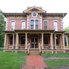
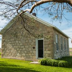
Robert William Andrew Feller Farmstead, Historic baseball farmstead in Van Meter, United States.

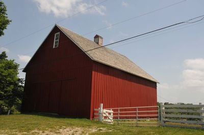
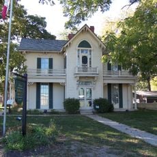
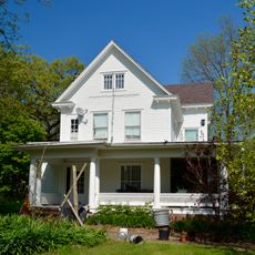
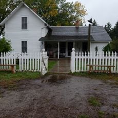
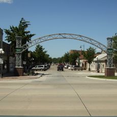
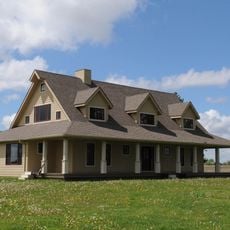
The Robert William Andrew Feller Farmstead is a historic property in Van Meter featuring a Tudor Revival house built in 1940 and a red barn dating to 1886. The approximately 40-acre site in Dallas County contains the original structures where a future baseball professional spent his childhood.

The farmstead was home to a boy who grew up in the 1920s while his father built a baseball field on the property in 1932. At age 17, the boy became one of the greatest pitchers of his era and made the farm part of his legendary career.

The farmstead was where a boy grew up playing baseball daily, a routine that shaped his entire life. The family used the property for both farming and training a young athlete who would become famous.

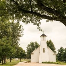
The property is listed on the National Register of Historic Places and welcomes visitors to explore its grounds. Walking around lets you see the spaces where training and daily life took place for someone who became a sports legend.

The area between the barn and house was not just a play space but an intentionally designed training ground that a father built for his son. This homemade training setup led to the development of techniques that later became professionally used.

The community of curious travelers

AroundUs brings together thousands of curated places, local tips, and hidden gems, enriched daily by 60,000 contributors worldwide.

Start exploring
Location
GPS coordinates
41.54580,-93.90810
Latest update
December 14, 2025 16:47
Around this place
Des Moines Art Center
United States of America

Des Moines Art Center

19.4 km
Salisbury House
United States of America

Salisbury House

20.1 km
Jordan House
United States of America

Jordan House

14.5 km
Walnut Woods State Park
United States of America

Walnut Woods State Park

13.8 km
Clive Greenbelt Trail
United States of America

Clive Greenbelt Trail

14.4 km
United States of America

Plymouth Church, Des Moines, Iowa

20 km
Dallas County Courthouse
United States of America

Dallas County Courthouse

12.1 km
Flynn Farm, Mansion, and Barn
United States of America

Flynn Farm, Mansion, and Barn

13.9 km
St. Patrick's Church
United States of America

St. Patrick's Church

16.4 km
Adel Bridge
United States of America

Adel Bridge

11.6 km
United States of America

Drake Municipal Observatory

19.2 km
Sylvan Theater Historic District
United States of America

Sylvan Theater Historic District

19.4 km
James Sansom Carpenter House
United States of America

James Sansom Carpenter House

17.9 km
Living History Farms
United States of America

Living History Farms

13.9 km
Linden Heights Historic District
United States of America

Linden Heights Historic District

19.5 km
Byron and Ivan Boyd House
United States of America

Byron and Ivan Boyd House

19.8 km
Valley Junction-West Des Moines City Hall and Engine House
United States of America

Valley Junction-West Des Moines City Hall and Engine House

16.8 km
I.O.O.F. Valley Junction Lodge Hall No. 604
United States of America

I.O.O.F. Valley Junction Lodge Hall No. 604

16.8 km
Plymouth Place
United States of America

Plymouth Place

20.1 km
Thomas I. Stoner House
United States of America

Thomas I. Stoner House

18.7 km
North River Stone Schoolhouse
United States of America

North River Stone Schoolhouse

19.5 km
Valley Junction Commercial Historic District
United States of America

Valley Junction Commercial Historic District

16.8 km
Olmsted Family Farmhouse
United States of America

Olmsted Family Farmhouse

19 km
Earlham Public School
United States of America

Earlham Public School

18.7 km
Adel Public Square Historic District
United States of America

Adel Public Square Historic District

12.2 km
William and Mary
United States of America

William and Mary

18.8 km
Kavanaugh Art Gallery
United States of America

Kavanaugh Art Gallery

16.8 km
Rider Way Bridge
United States of America

Rider Way Bridge

19.8 km
Show the full map
« Robert William Andrew Feller Farmstead - Historic baseball farmstead in Van Meter, United States » is provided by Around Us (aroundus.com). Images and texts are derived from Wikimedia project under a Creative Commons license. You are allowed to copy, distribute, and modify copies of this page, under the conditions set by the license, as long as this note is clearly visible.

Discover hidden gems everywhere you go!

From secret cafés to breathtaking viewpoints, skip the crowded tourist spots and find places that match your style. Our app makes it easy with voice search, smart filtering, route optimization, and insider tips from travelers worldwide. Download now for the complete mobile experience.

Around Us App Screenshot

A unique approach to discovering new places

Le Figaro

All the places worth exploring

France Info

A tailor-made excursion in just a few clicks

20 Minutes

Around Us
Travel Guide & Maps
Download

Send to your phone

QR Code
1

Open the camera app on your mobile.

2

Point at the QR code with your camera. A notification will appear.

3

Tap the notification to open the link.