Enable Location

We need your location to show you interesting places around you

Discover nearby places

Find interesting locations and hidden gems around you

Precise directions

Get accurate directions and distances to places

Your location is never shared with other users. It's only used when you tap the location button.

County Farm Bridge

Log in to your account

Start exploring — it's free

Trusted by 62,076 travelers worldwide

Continue with Google
Continue with Apple
or

We will send you a code to connect

By continuing, you accept our Terms and Conditions and our Privacy Policy

Check your inbox

We've sent a pincode in your inbox. Please enter the code below.

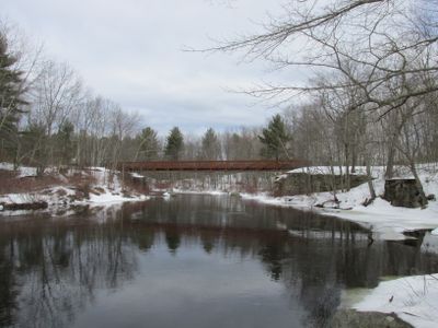
County Farm Bridge, Wooden covered bridge in New Hampshire, United States

County Farm Bridge is a covered wooden structure that carries traffic across a waterway in New Hampshire using traditional timber framework construction. The span features exposed wooden trusses arranged to distribute weight evenly, all sheltered beneath a protective roof that covers the entire crossing.

This bridge was built during the 1800s when covered designs became common practice to shelter wooden structures from weather damage and rot. Its construction methods reflect the engineering approach of that era and stand as evidence of how infrastructure was adapted to local materials and conditions.

The bridge shows visitors how 19th-century builders solved practical problems through clever construction techniques that have lasted for generations. People come here to understand and appreciate the craftsmanship that went into creating a structure strong enough to survive over a century of use.

The bridge is accessible by vehicle or on foot, with parking available nearby for easy access. Walking across allows you to appreciate the wooden structure and craftsmanship up close from inside the covered passage.

The structure earned a spot on the National Register of Historic Places, which brings dedicated attention to maintaining its original features. This official recognition helps ensure that efforts to preserve the bridge continue to receive support and resources.

The community of curious travelers

AroundUs brings together thousands of curated places, local tips, and hidden gems, enriched daily by 60,000 contributors worldwide.

Start exploring
Location
GPS coordinates
43.22060,-70.94390
Latest update
December 14, 2025 18:05
Around this place
Wildcat Stadium
United States of America

Wildcat Stadium

9.1 km
Woodman Institute Museum
United States of America

Woodman Institute Museum

6.6 km
Thompson Hall
United States of America

Thompson Hall

9.5 km
Cocheco Mills
United States of America

Cocheco Mills

6.4 km
Rochester Opera House
United States of America

Rochester Opera House

9.8 km
Bellamy Reservoir
United States of America

Bellamy Reservoir

3.7 km
First Parish Church
United States of America

First Parish Church

7.1 km
Center for Coastal & Ocean Mapping
United States of America

Center for Coastal & Ocean Mapping

9.5 km
United States of America

University of New Hampshire Observatory

8.2 km
United States of America

Jesse Hepler Lilac Arboretum

9.4 km
Memorial Union Building
United States of America

Memorial Union Building

9.7 km
Rochester Museum of Fine Arts
United States of America

Rochester Museum of Fine Arts

9.7 km
Saint Thomas More Parish
United States of America

Saint Thomas More Parish

9.7 km
Rochester Commercial and Industrial District
United States of America

Rochester Commercial and Industrial District

9.5 km
Sawyer Woolen Mills
United States of America

Sawyer Woolen Mills

7.2 km
Former Berwick High School
United States of America

Former Berwick High School

8.6 km
Samuel Wyatt House
United States of America

Samuel Wyatt House

6.4 km
Green Street School
United States of America

Green Street School

7.6 km
William Hale House
United States of America

William Hale House

6.3 km
Old Somersworth High School
United States of America

Old Somersworth High School

7.7 km
Religious Society of Friends Meetinghouse
United States of America

Religious Society of Friends Meetinghouse

6.8 km
Michael Reade House
United States of America

Michael Reade House

6.4 km
Jenness Farm
United States of America

Jenness Farm

2.6 km
Richard Hayes House
United States of America

Richard Hayes House

5.3 km
Lehoullier Building
United States of America

Lehoullier Building

7.8 km
Woodman Institute Museum
United States of America

Woodman Institute Museum

6.6 km
Paul Creative Arts Center
United States of America

Paul Creative Arts Center

9.6 km
Washington Street Overpass
United States of America

Washington Street Overpass

5.6 km
Show the full map
« County Farm Bridge - Wooden covered bridge in New Hampshire, United States » is provided by Around Us (aroundus.com). Images and texts are derived from Wikimedia project under a Creative Commons license. You are allowed to copy, distribute, and modify copies of this page, under the conditions set by the license, as long as this note is clearly visible.

Discover hidden gems everywhere you go!

From secret cafés to breathtaking viewpoints, skip the crowded tourist spots and find places that match your style. Our app makes it easy with voice search, smart filtering, route optimization, and insider tips from travelers worldwide. Download now for the complete mobile experience.

Around Us App Screenshot

A unique approach to discovering new places

Le Figaro

All the places worth exploring

France Info

A tailor-made excursion in just a few clicks

20 Minutes

Around Us
Travel Guide & Maps
Download

Send to your phone

QR Code
1

Open the camera app on your mobile.

2

Point at the QR code with your camera. A notification will appear.

3

Tap the notification to open the link.