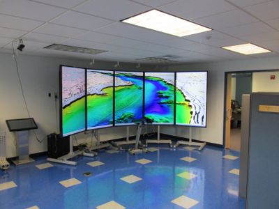
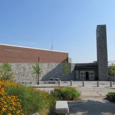
Center for Coastal & Ocean Mapping, Marine research facility at University of New Hampshire, United States.
The Center for Coastal and Ocean Mapping is a research facility at the University of New Hampshire focused on processing sonar data and developing mapping technologies for marine environments. Located in the Chase Ocean Engineering building, the laboratories use specialized equipment to analyze seafloor features and create detailed charts of ocean depths.
This facility was founded in 2000 by Dr. Larry Mayer and formed a partnership with NOAA to create a national center for ocean mapping and hydrographic sciences. That collaboration positioned it as a leading institution for advancing how we understand and navigate the world's oceans.
This place serves as a training ground where future oceanographers and cartographers develop skills in marine data collection and underwater mapping. You can observe students working with real oceanographic data and learning to interpret the ocean floor.
The facility is best visited during daytime hours when research and teaching activities are underway. Call ahead or check online to see which parts of the center can be accessed, as some laboratory areas have restricted entry to protect ongoing experiments.
The center uses uncrewed surface vehicles to track whales in the Gulf of Maine and Arctic waters while simultaneously mapping the seafloor in real time. This technology allows researchers to gather data from remote locations that would be difficult or impossible to reach with traditional ships.
The community of curious travelers
AroundUs brings together thousands of curated places, local tips, and hidden gems, enriched daily by 60,000 contributors worldwide.