Enable Location

We need your location to show you interesting places around you

Discover nearby places

Find interesting locations and hidden gems around you

Precise directions

Get accurate directions and distances to places

Your location is never shared with other users. It's only used when you tap the location button.

J. A. Belt Building

Log in to your account

Start exploring — it's free

Trusted by 62,829 travelers worldwide

Continue with Google
Continue with Apple
or

We will send you a code to connect

By continuing, you accept our Terms and Conditions and our Privacy Policy

Check your inbox

We've sent a pincode in your inbox. Please enter the code below.

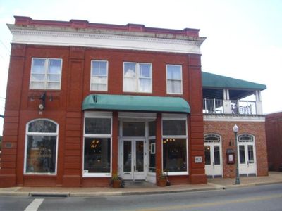
J. A. Belt Building, United States historic place

The J. A. Belt Building is a historic commercial structure in Gaithersburg, Maryland, built in 1903 from red brick with two floors and a simple rectangular design. Large windows on the street level were designed for displaying merchandise, with smaller windows above serving the upper floor spaces.

The building was constructed in 1903 as a commercial space, with the founding year and J. A. Belt's name inscribed in the brickwork. It was added to the National Register of Historic Places in 1984, recognizing its importance in understanding local history and early twentieth-century architecture.

The building is named after J. A. Belt, a successful businessman who played an important role in Montgomery County during the late 1800s and early 1900s. His name displayed on the structure reflects how individual enterprise shaped the economic development of the community.

The building is located along East Diamond Avenue in downtown Gaithersburg and is easily accessible on foot, especially when exploring other historic sites and shops nearby. Its small footprint makes it simple to view and include in walking tours without requiring special arrangements.

A raised half-circle feature on the building's east side contains the year 1903 inscribed alongside J. A. Belt's name in the brick itself. This carved inscription represents an unusual practice where early twentieth-century builders literally embedded the founder's identity into the structure's permanent materials.

The community of curious travelers

AroundUs brings together thousands of curated places, local tips, and hidden gems, enriched daily by 60,000 contributors worldwide.

Start exploring
Location
GPS coordinates
39.14220,-77.19420
Latest update
February 9, 2026 07:46
Around this place
Glenstone
United States of America

Glenstone

10.3 km
Seneca Creek State Park
United States of America

Seneca Creek State Park

5.4 km
Lake Needwood
United States of America

Lake Needwood

6.1 km
Third Addition to Rockville and Old St. Mary's Church and Cemetery
United States of America

Third Addition to Rockville and Old St. Mary's Church and Cemetery

7.9 km
Glenview Farm
United States of America

Glenview Farm

8.4 km
Beall-Dawson House
United States of America

Beall-Dawson House

7.3 km
Gaithersburg Latitude Observatory
United States of America

Gaithersburg Latitude Observatory

749 m
Lakelands Park
United States of America

Lakelands Park

4.7 km
Falls Road Park
United States of America

Falls Road Park

8.8 km
Travilah Oak
United States of America

Travilah Oak

10.2 km
Latvian Museum
United States of America

Latvian Museum

6.3 km
West Montgomery Avenue Historic District
United States of America

West Montgomery Avenue Historic District

7.1 km
The Ridge
United States of America

The Ridge

7.1 km
Bingham-Brewer House
United States of America

Bingham-Brewer House

7.4 km
Frieda Fromm-Reichmann Cottage
United States of America

Frieda Fromm-Reichmann Cottage

7.1 km
Rockville Park Historic District
United States of America

Rockville Park Historic District

8.2 km
Darnestown Presbyterian Church
United States of America

Darnestown Presbyterian Church

9 km
Layton House
United States of America

Layton House

8.9 km
Gaithersburg Water Park
United States of America

Gaithersburg Water Park

1.1 km
Oaks II
United States of America

Oaks II

8.7 km
Lake Bernard Frank
United States of America

Lake Bernard Frank

8 km
Montgomery County Circuit Courthouses
United States of America

Montgomery County Circuit Courthouses

7.6 km
Muddy Branch
United States of America

Muddy Branch

9.2 km
Serpentine Barrens Conservation Park
United States of America

Serpentine Barrens Conservation Park

8.9 km
David Scull Park
United States of America

David Scull Park

7.5 km
Hillcrest Park
United States of America

Hillcrest Park

9 km
Germantown Library
United States of America

Germantown Library

7.6 km
Rockville Memorial Library
United States of America

Rockville Memorial Library

7.2 km
Show the full map
« J. A. Belt Building - United States historic place » is provided by Around Us (aroundus.com). Images and texts are derived from Wikimedia project under a Creative Commons license. You are allowed to copy, distribute, and modify copies of this page, under the conditions set by the license, as long as this note is clearly visible.

Discover hidden gems everywhere you go!

From secret cafés to breathtaking viewpoints, skip the crowded tourist spots and find places that match your style. Our app makes it easy with voice search, smart filtering, route optimization, and insider tips from travelers worldwide. Download now for the complete mobile experience.

Around Us App Screenshot

A unique approach to discovering new places

Le Figaro

All the places worth exploring

France Info

A tailor-made excursion in just a few clicks

20 Minutes

Around Us
Travel Guide & Maps
Download

Send to your phone

QR Code
1

Open the camera app on your mobile.

2

Point at the QR code with your camera. A notification will appear.

3

Tap the notification to open the link.