Enable Location

We need your location to show you interesting places around you

Discover nearby places

Find interesting locations and hidden gems around you

Precise directions

Get accurate directions and distances to places

Your location is never shared with other users. It's only used when you tap the location button.

Old Huntington High School

Log in to your account

Start exploring — it's free

Trusted by 62,544 travelers worldwide

Continue with Google
Continue with Apple
or

We will send you a code to connect

By continuing, you accept our Terms and Conditions and our Privacy Policy

Check your inbox

We've sent a pincode in your inbox. Please enter the code below.

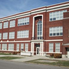
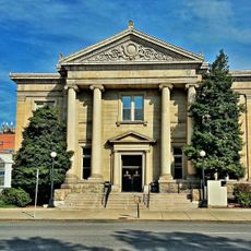
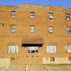
Old Huntington High School, public school in Huntington, West Virginia, United States

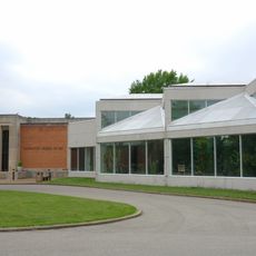
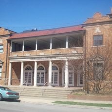
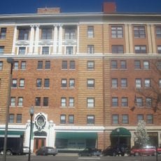
Old Huntington High School is a neoclassical building constructed from buff-colored brick with four and a half stories and a U-shaped floor plan formed by a central block and two wings. The main structure spans over 155,000 square feet with a central courtyard surrounded by three later additions, plus a separate red brick building originally used as a carriage house and kitchen.

Designed by architect Verus T. Ritter and opened on September 4, 1916, the building served as a high school for roughly eighty years until its closure in 1996. After merging with another school, the structure was repurposed and gained recognition on the National Register of Historic Places in 2000.

The building served as a gathering place for generations of Huntington residents and shaped the town's sense of community pride. Its classical design with columns and balanced proportions reflects the era when public institutions were built to inspire and endure.

The building now houses apartments, artist studios, a small gallery, and a YMCA branch, offering visitors several reasons to explore the space. Access varies depending on which facilities are open, so it helps to plan your visit around the schedules of these different operations.

In 1964, the building served as a filming location for the movie Teen-Age Strangler, creating an unexpected connection between this educational institution and local film history. This cinematic moment adds an intriguing layer to the site's story beyond its role in the community.

The community of curious travelers

AroundUs brings together thousands of curated places, local tips, and hidden gems, enriched daily by 60,000 contributors worldwide.

Start exploring
Location
Architectural style
Neoclassical architecture
GPS coordinates
38.41361,-82.44333
Latest update
February 9, 2026 08:22
Around this place
Camden Park
United States of America

Camden Park

852 m
Joan C. Edwards Stadium
United States of America

Joan C. Edwards Stadium

2.3 km
Fairfield Stadium
United States of America

Fairfield Stadium

1.1 km
Huntington Museum of Art
United States of America

Huntington Museum of Art

2.4 km
Cam Henderson Center
United States of America

Cam Henderson Center

1.9 km
Keith-Albee Theatre
United States of America

Keith-Albee Theatre

807 m
Chesapeake and Ohio 1308
United States of America

Chesapeake and Ohio 1308

3.1 km
Robert C. Byrd Bridge
United States of America

Robert C. Byrd Bridge

1.4 km
Old Main
United States of America

Old Main

1.5 km
Douglass Junior and Senior High School
United States of America

Douglass Junior and Senior High School

1 km
Ritter Park Historic District
United States of America

Ritter Park Historic District

1.2 km
Cabell County Courthouse
United States of America

Cabell County Courthouse

729 m
Downtown Huntington Historic District
United States of America

Downtown Huntington Historic District

3.7 km
Pink Bridge
United States of America

Pink Bridge

782 m
Memorial Arch
United States of America

Memorial Arch

1.9 km
Ohev Sholom Temple
United States of America

Ohev Sholom Temple

330 m
Carnegie Public Library
United States of America

Carnegie Public Library

705 m
Elk River Coal and Lumber Company No. 10
United States of America

Elk River Coal and Lumber Company No. 10

1.1 km
United States Post Office and Court House
United States of America

United States Post Office and Court House

591 m
Barnett Hospital and Nursing School
United States of America

Barnett Hospital and Nursing School

668 m
Campbell-Hicks House
United States of America

Campbell-Hicks House

797 m
Simms School Building
United States of America

Simms School Building

1.5 km
Mortimer Place Historic District
United States of America

Mortimer Place Historic District

631 m
Ricketts House
United States of America

Ricketts House

2.9 km
Prichard House
United States of America

Prichard House

666 m
Masonic Temple
United States of America

Masonic Temple

1 km
Johnston-Meek House
United States of America

Johnston-Meek House

983 m
Ninth Street West Historic District
United States of America

Ninth Street West Historic District

2.4 km
Show the full map
« Old Huntington High School - public school in Huntington, West Virginia, United States » is provided by Around Us (aroundus.com). Images and texts are derived from Wikimedia project under a Creative Commons license. You are allowed to copy, distribute, and modify copies of this page, under the conditions set by the license, as long as this note is clearly visible.

Discover hidden gems everywhere you go!

From secret cafés to breathtaking viewpoints, skip the crowded tourist spots and find places that match your style. Our app makes it easy with voice search, smart filtering, route optimization, and insider tips from travelers worldwide. Download now for the complete mobile experience.

Around Us App Screenshot

A unique approach to discovering new places

Le Figaro

All the places worth exploring

France Info

A tailor-made excursion in just a few clicks

20 Minutes

Around Us
Travel Guide & Maps
Download

Send to your phone

QR Code
1

Open the camera app on your mobile.

2

Point at the QR code with your camera. A notification will appear.

3

Tap the notification to open the link.