Mount Gilead State Park

Log in to your account

AroundUs is a community-driven map of interesting places, built by curious explorers like you. It grows with every review, story, and photo you share.
Connect to save your favorite spots, contribute locations, and create personalized routes.
Continue with Google
Continue with Apple
Continue with X
Continue with Facebook
Continue with email
By continuing, you accept our Terms and Conditions and our Privacy Policy
Create an account

Mount Gilead State Park

Add to collection
Map
Suggest a change
Share

Mount Gilead State Park, State park with lakes in Mount Gilead, United States.

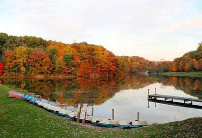
Mount Gilead State Park is a public recreation area featuring two connected lakes and trails through forest. The park sprawls across wooded terrain with open shorelines and sandy areas for swimming and picnicking.

A dam was built across Sam's Creek in the early 1900s to create the first lake. The park gained its official status in 1949 after a second lake was added during the 1930s.

The Mount Gilead area served as a stopping point on the Underground Railroad during the 1800s. This history shapes how locals and visitors understand the region's connection to the freedom movement.

The park provides camping sites with electrical service, including some with full water and sewer connections, and shower buildings are available. Visitors should bring supplies for activities like boating and hiking since amenities are limited beyond basic camping needs.

Only electric motors are permitted on the lakes to keep the water environment quiet and clean. The park also features accessible canoes and kayaks for people with disabilities, along with an outdoor amphitheater where nature programs and concerts take place.

Location: Morrow County

Inception: 1949

Website: https://ohiodnr.gov/go-and-do/plan-a-visit/find-a-property/mt-gilean-state-park

GPS coordinates: 40.55000,-82.81670

Latest update: December 14, 2025 13:04

Photos
Around this place
Mid-Ohio Sports Car Course
United States of America

Mid-Ohio Sports Car Course

21.7 km
Formula F at the SCCA National Championship Runoffs
United States of America

Formula F at the SCCA National Championship Runoffs

21.7 km
Clear Fork Reservoir
United States of America

Clear Fork Reservoir

24.2 km
Caledonia Bowstring Bridge
United States of America

Caledonia Bowstring Bridge

16.3 km
James S. Trimble House
United States of America

James S. Trimble House

1.5 km
Morrow County Courthouse
United States of America

Morrow County Courthouse

871 m
Brownella Cottage and Grace Episcopal Church and Rectory
United States of America

Brownella Cottage and Grace Episcopal Church and Rectory

20.5 km
Raleigh Mound
United States of America

Raleigh Mound

24.7 km
Chambers Road Covered Bridge
United States of America

Chambers Road Covered Bridge

23.6 km
Chesterville Community Church
United States of America

Chesterville Community Church

13.9 km
Chester Town Hall
United States of America

Chester Town Hall

13.8 km
First Congregational Church and Lexington School
United States of America

First Congregational Church and Lexington School

24.1 km
Levering Hall
United States of America

Levering Hall

977 m
Galion Theatre
United States of America

Galion Theatre

20.6 km
Perry Cook Memorial Public Library
United States of America

Perry Cook Memorial Public Library

15.2 km
Capitol Theatre
United States of America

Capitol Theatre

1.1 km
Selover Public Library
United States of America

Selover Public Library

13.6 km
Olentangy Battle Monument
United States of America

Olentangy Battle Monument

25.4 km
Mount Gilead Pool
United States of America

Mount Gilead Pool

1.2 km
Neal Theatre
United States of America

Neal Theatre

24.4 km
Cardington-lincoln Public Library
United States of America

Cardington-lincoln Public Library

8.5 km
Galion Public Library Association
United States of America

Galion Public Library Association

20.7 km
Lexington Branch Library
United States of America

Lexington Branch Library

24.4 km
Caledonia Branch
United States of America

Caledonia Branch

16 km
Mt Gilead Public Library
United States of America

Mt Gilead Public Library

850 m
Fredericktown Branch
United States of America

Fredericktown Branch

24.2 km
Scioto Ordnance Plant Site
United States of America

Scioto Ordnance Plant Site

23.9 km
Fredericktown Community Fire District
United States of America

Fredericktown Community Fire District

24.2 km
Show the full map
Reviews

Visited this place? Tap the stars to rate it and share your experience / photos with the community! Try now! You can cancel it anytime.

« Mount Gilead State Park - State park with lakes in Mount Gilead, United States » is provided by Around Us (aroundus.com). Images and texts are derived from Wikimedia project under a Creative Commons license. You are allowed to copy, distribute, and modify copies of this page, under the conditions set by the license, as long as this note is clearly visible.

Discover hidden gems everywhere you go!

From secret cafés to breathtaking viewpoints, skip the crowded tourist spots and find places that match your style. Our app makes it easy with voice search, smart filtering, route optimization, and insider tips from travelers worldwide. Download now for the complete mobile experience.

Around Us App Screenshot

A unique approach to discovering new places

Le Figaro

All the places worth exploring

France Info

A tailor-made excursion in just a few clicks

20 Minutes