Enable Location

We need your location to show you interesting places around you

Discover nearby places

Find interesting locations and hidden gems around you

Precise directions

Get accurate directions and distances to places

Your location is never shared with other users. It's only used when you tap the location button.

Nipmuck Trail

Log in to your account

Start exploring — it's free

Trusted by 62,557 travelers worldwide

Continue with Google
Continue with Apple
or

We will send you a code to connect

By continuing, you accept our Terms and Conditions and our Privacy Policy

Check your inbox

We've sent a pincode in your inbox. Please enter the code below.

Nipmuck Trail

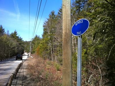
Nipmuck Trail, Weg in den Vereinigten Staaten

Nipmuck Trail is a hiking path extending about 34 miles from Mansfield in the south to Breakneck Pond near the Massachusetts border in the north. The trail winds through state forests, conservation areas, and university land, passing by Mansfield Hollow Lake and featuring notable spots like Pixie Falls and Wolf Rock along the way.

The trail has roots in the movements of Nipmuc Native Americans and early settlers who used and shaped these landscapes. Over time it developed as an important hiking route, with modern stewardship since 2010 by the Connecticut Forest and Park Association protecting over 500 acres of surrounding forest.

The name Nipmuck comes from the Nipmuc Native Americans who once lived in this region. Visitors walking certain sections today follow the Old Connecticut Path, an ancient route that connected communities and shaped how people moved through these forests.

The trail is marked with blue rectangles and can be accessed from several parking areas including Puddin Lane and near Mansfield Hollow State Park. Check recent reports about flooding or trail conditions before visiting, as natural areas can change with weather and seasonal conditions.

Ladies Room Rock is a large flat boulder that feels like a hidden spot only attentive hikers discover along the way. Coye Hill marks the highest point and offers a surprising panoramic view across the surrounding region.

The community of curious travelers

AroundUs brings together thousands of curated places, local tips, and hidden gems, enriched daily by 60,000 contributors worldwide.

Start exploring
Location
GPS coordinates
41.76556,-72.21750
Latest update
February 9, 2026 08:23
Around this place
Harry A. Gampel Pavilion
United States of America

Harry A. Gampel Pavilion

5.4 km
Frog Bridge
United States of America

Frog Bridge

6.2 km
Memorial Stadium
United States of America

Memorial Stadium

5.3 km
Mark Edward Freitas Ice Forum
United States of America

Mark Edward Freitas Ice Forum

4.9 km
University of Connecticut Historic District
United States of America

University of Connecticut Historic District

5.5 km
Morrone Stadium
United States of America

Morrone Stadium

5 km
Connecticut Repertory Theatre
United States of America

Connecticut Repertory Theatre

4.8 km
William Benton Museum of Art
United States of America

William Benton Museum of Art

5.6 km
Connecticut State Museum of Natural History
United States of America

Connecticut State Museum of Natural History

5.2 km
Connecticut Eastern Railroad Museum
United States of America

Connecticut Eastern Railroad Museum

5.8 km
Jorgensen Center for the Performing Arts
United States of America

Jorgensen Center for the Performing Arts

5.8 km
Mansfield Hollow State Park
United States of America

Mansfield Hollow State Park

3.5 km
Willimantic Footbridge
United States of America

Willimantic Footbridge

6 km
Ballard Institute and Museum of Puppetry
United States of America

Ballard Institute and Museum of Puppetry

4.9 km
Windham Textile and History Museum
United States of America

Windham Textile and History Museum

6.2 km
The Dodd Center for Human Rights
United States of America

The Dodd Center for Human Rights

5.3 km
Windham Town Hall
United States of America

Windham Town Hall

5.8 km
Mansfield Hollow Historic District
United States of America

Mansfield Hollow Historic District

2.8 km
Main Street Historic District
United States of America

Main Street Historic District

5.9 km
Spring Hill Historic District
United States of America

Spring Hill Historic District

2.8 km
Gurleyville Historic District
United States of America

Gurleyville Historic District

5.3 km
William Jillson Stone House
United States of America

William Jillson Stone House

6.1 km
Eleazer Williams House
United States of America

Eleazer Williams House

1.5 km
Old Willimantic Post Office
United States of America

Old Willimantic Post Office

5.9 km
Mansfield Center Cemetery
United States of America

Mansfield Center Cemetery

1.8 km
Windham Textile & History Museum (the Mill Museum)
United States of America

Windham Textile & History Museum (the Mill Museum)

6.2 km
Willimantic Movieplex
United States of America

Willimantic Movieplex

6.2 km
Mansfield Center Historic District
United States of America

Mansfield Center Historic District

2 km
Show the full map
« Nipmuck Trail - Weg in den Vereinigten Staaten » is provided by Around Us (aroundus.com). Images and texts are derived from Wikimedia project under a Creative Commons license. You are allowed to copy, distribute, and modify copies of this page, under the conditions set by the license, as long as this note is clearly visible.

Discover hidden gems everywhere you go!

From secret cafés to breathtaking viewpoints, skip the crowded tourist spots and find places that match your style. Our app makes it easy with voice search, smart filtering, route optimization, and insider tips from travelers worldwide. Download now for the complete mobile experience.

Around Us App Screenshot

A unique approach to discovering new places

Le Figaro

All the places worth exploring

France Info

A tailor-made excursion in just a few clicks

20 Minutes

Around Us
Travel Guide & Maps
Download

Send to your phone

QR Code
1

Open the camera app on your mobile.

2

Point at the QR code with your camera. A notification will appear.

3

Tap the notification to open the link.