Enable Location

We need your location to show you interesting places around you

Discover nearby places

Find interesting locations and hidden gems around you

Precise directions

Get accurate directions and distances to places

Your location is never shared with other users. It's only used when you tap the location button.

James Wynn House

Log in to your account

Start exploring — it's free

Trusted by 62,526 travelers worldwide

Continue with Google
Continue with Apple
or

We will send you a code to connect

By continuing, you accept our Terms and Conditions and our Privacy Policy

Check your inbox

We've sent a pincode in your inbox. Please enter the code below.

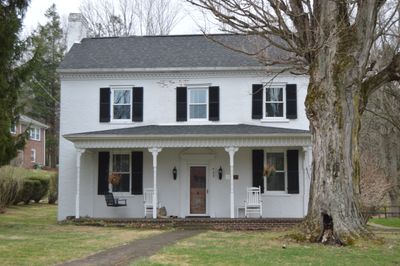
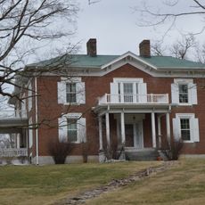
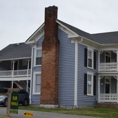
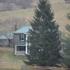
James Wynn House, Tazewell, Virginia, listed on the NRHP in Virginia

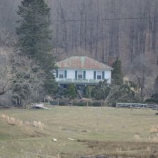
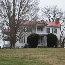
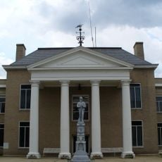
The James Wynn House is a two-story brick residence in Tazewell, Virginia, built around 1828 and listed on the National Register of Historic Places. It has a rectangular shape with three sections across the front, a gable roof with chimneys at each end, and features Federal-period woodwork inside with Flemish-bond brickwork on its facade.

The house was built around 1828 by James Wynn, a prominent member of the community whose father William Wynn was a Quaker pioneer. The property later passed to William Owen Yost in 1858, and then to John Newton Harman, a lawyer and minister, and his wife Bettie in 1919.

The house bears the name of James Wynn, whose family were among the early settlers of Tazewell County. Its brick facade with Flemish-bond brickwork shows the craftsmanship and building techniques that were valued during that era.

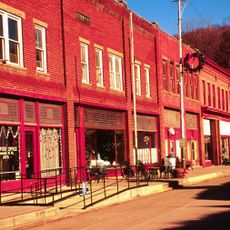
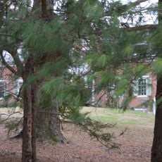
The house sits in a semi-rural setting near the center of Tazewell and can be seen from the road, though it remains a private residence. Visitors should always respect the owners' privacy and not enter the property.

James Wynn operated a tannery near his house where animal hides were processed into leather, and the business continued under different owners for many years. This connection reveals the economic activities and trades that supported families in the early settlement of the region.

The community of curious travelers

AroundUs brings together thousands of curated places, local tips, and hidden gems, enriched daily by 60,000 contributors worldwide.

Start exploring
Location
GPS coordinates
37.11417,-81.51944
Latest update
February 9, 2026 07:44
Around this place
Hungry Mother State Park
United States of America

Hungry Mother State Park

26 km
Big Walker Lookout
United States of America

Big Walker Lookout

27 km
Pinnacle Rock State Park
United States of America

Pinnacle Rock State Park

30.9 km
Mountain Glen
United States of America

Mountain Glen

20.8 km
United States of America

Beartown Wilderness

8.6 km
Maiden Spring
United States of America

Maiden Spring

17.1 km
Pocahontas Fuel Company Store and Office Buildings
United States of America

Pocahontas Fuel Company Store and Office Buildings

21.5 km
Walter McDonald Sanders House
United States of America

Walter McDonald Sanders House

26.9 km
Bramwell Historic District
United States of America

Bramwell Historic District

29.8 km
Big Crab Orchard Site
United States of America

Big Crab Orchard Site

4.9 km
Sharon Lutheran Church and Cemetery
United States of America

Sharon Lutheran Church and Cemetery

18.6 km
Alexander St. Clair House
United States of America

Alexander St. Clair House

22.5 km
Page Coal and Coke Company Store
United States of America

Page Coal and Coke Company Store

26.6 km
Kimberling Lutheran Cemetery
United States of America

Kimberling Lutheran Cemetery

29 km
George Oscar Thompson House
United States of America

George Oscar Thompson House

5.7 km
Chimney Rock Farm
United States of America

Chimney Rock Farm

9 km
Tazewell Historic District
United States of America

Tazewell Historic District

390 m
Capt. James Moore Homestead
United States of America

Capt. James Moore Homestead

20.5 km
Richlands Historic District
United States of America

Richlands Historic District

25.5 km
Bramwell Additions Historic District
United States of America

Bramwell Additions Historic District

29.8 km
Pocahontas Historic District
United States of America

Pocahontas Historic District

26.6 km
Easley House
United States of America

Easley House

29.3 km
Williams House
United States of America

Williams House

24.9 km
Clinch Valley Roller Mills
United States of America

Clinch Valley Roller Mills

22.1 km
Old Kentucky Turnpike Historic District
United States of America

Old Kentucky Turnpike Historic District

21.9 km
Clynchdale
United States of America

Clynchdale

5.4 km
Tazewell Avenue Historic District
United States of America

Tazewell Avenue Historic District

25.5 km
Pocahontas Exhibition Coal Mine & Museum
United States of America

Pocahontas Exhibition Coal Mine & Museum

26.4 km
Show the full map
« James Wynn House - Tazewell, Virginia, listed on the NRHP in Virginia » is provided by Around Us (aroundus.com). Images and texts are derived from Wikimedia project under a Creative Commons license. You are allowed to copy, distribute, and modify copies of this page, under the conditions set by the license, as long as this note is clearly visible.

Discover hidden gems everywhere you go!

From secret cafés to breathtaking viewpoints, skip the crowded tourist spots and find places that match your style. Our app makes it easy with voice search, smart filtering, route optimization, and insider tips from travelers worldwide. Download now for the complete mobile experience.

Around Us App Screenshot

A unique approach to discovering new places

Le Figaro

All the places worth exploring

France Info

A tailor-made excursion in just a few clicks

20 Minutes

Around Us
Travel Guide & Maps
Download

Send to your phone

QR Code
1

Open the camera app on your mobile.

2

Point at the QR code with your camera. A notification will appear.

3

Tap the notification to open the link.