Enable Location

We need your location to show you interesting places around you

Discover nearby places

Find interesting locations and hidden gems around you

Precise directions

Get accurate directions and distances to places

Your location is never shared with other users. It's only used when you tap the location button.

Big Walker Lookout

Log in to your account

Start exploring — it's free

Trusted by 64,510 travelers worldwide

Continue with Google
Continue with Apple
or

We will send you a code to connect

By continuing, you accept our Terms and Conditions and our Privacy Policy

Check your inbox

We've sent a pincode in your inbox. Please enter the code below.

Big Walker Lookout
Discussion Reviews 1 Photos
4.5k Popularity

Big Walker Lookout, Observation tower in Bland County, United States.

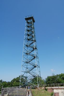
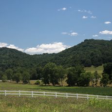
Big Walker Lookout is a steel observation tower on Big Walker Mountain in Bland County, Virginia, rising to about 100 feet (30 m) at an elevation of roughly 3,400 feet (1,040 m). From the platform at the top, visitors can see across the surrounding ridges and into several neighboring states.

The Kime family built the tower in 1947, making it Virginia's first private scenic attraction, near a mountain pass that had already seen military movement during the Civil War. The pass had served as a key route through the mountains for decades before the tower was built.

On weekends between May and October, bluegrass music and craft demonstrations take place at the site, where visitors can also meet regional authors. These gatherings give a direct sense of the artistic traditions that still shape life in the surrounding mountain communities.

Reaching the observation platform means climbing a staircase inside the tower, so comfortable shoes are a good idea. Morning hours tend to offer the clearest views and a quieter visit overall.

The site marks the starting point of a Virginia Civil War Trails driving route focused on an 1863 military action near Wytheville. Following this route from here links the view from the tower to a very specific chapter of the war that played out just a short drive away.

The community of curious travelers

AroundUs brings together thousands of curated places, local tips, and hidden gems, enriched daily by 60,000 contributors worldwide.

Start exploring
Location
GPS coordinates
37.04573,-81.22831
Latest update
March 3, 2026 08:12
Around this place
The Mansion at Fort Chiswell
United States of America

The Mansion at Fort Chiswell

28.2 km
Mountain Glen
United States of America

Mountain Glen

10.2 km
United States of America

Walker Mountain Cluster

7.4 km
Wytheville Historic District
United States of America

Wytheville Historic District

17.1 km
United States of America

Beartown Wilderness

19.2 km
Walter McDonald Sanders House
United States of America

Walter McDonald Sanders House

21.7 km
Hancock House
United States of America

Hancock House

25.6 km
Little Dry Run Wilderness
United States of America

Little Dry Run Wilderness

29 km
Loretto
United States of America

Loretto

16.4 km
Wolf Creek Bridge
United States of America

Wolf Creek Bridge

24.5 km
Crockett's Cove Presbyterian Church
United States of America

Crockett's Cove Presbyterian Church

17.1 km
James Wynn House
United States of America

James Wynn House

27 km
Wythe County Poorhouse Farm
United States of America

Wythe County Poorhouse Farm

19.2 km
Sharon Lutheran Church and Cemetery
United States of America

Sharon Lutheran Church and Cemetery

11.3 km
Alexander St. Clair House
United States of America

Alexander St. Clair House

22.2 km
Kimberling Lutheran Cemetery
United States of America

Kimberling Lutheran Cemetery

15.8 km
George Oscar Thompson House
United States of America

George Oscar Thompson House

29.2 km
Reed Creek Mill
United States of America

Reed Creek Mill

18.4 km
Tazewell Historic District
United States of America

Tazewell Historic District

27.2 km
Zion Evangelical Lutheran Church Cemetery
United States of America

Zion Evangelical Lutheran Church Cemetery

22.8 km
Haller-Gibboney Rock House
United States of America

Haller-Gibboney Rock House

16.6 km
Capt. James Moore Homestead
United States of America

Capt. James Moore Homestead

28.8 km
South Bluefield Historic District
United States of America

South Bluefield Historic District

23.7 km
Pocahontas Historic District
United States of America

Pocahontas Historic District

30.9 km
Easley House
United States of America

Easley House

22.8 km
Junius Marcellus Updyke Farm
United States of America

Junius Marcellus Updyke Farm

19.4 km
Clynchdale
United States of America

Clynchdale

22.3 km
Municipal Building
United States of America

Municipal Building

24.7 km
Show the full map
Reviews
Share your experience

No review yet

Discussions
Start a discussion...

No discussion yet

« Big Walker Lookout - Observation tower in Bland County, United States » is provided by Around Us (aroundus.com). Images and texts are derived from Wikimedia project under a Creative Commons license. You are allowed to copy, distribute, and modify copies of this page, under the conditions set by the license, as long as this note is clearly visible.

Discover hidden gems everywhere you go!

From secret cafés to breathtaking viewpoints, skip the crowded tourist spots and find places that match your style. Our app makes it easy with voice search, smart filtering, route optimization, and insider tips from travelers worldwide. Download now for the complete mobile experience.

Around Us App Screenshot

A unique approach to discovering new places

Le Figaro

All the places worth exploring

France Info

A tailor-made excursion in just a few clicks

20 Minutes

Around Us
Travel Guide & Maps
Download

Send to your phone

QR Code
1

Open the camera app on your mobile.

2

Point at the QR code with your camera. A notification will appear.

3

Tap the notification to open the link.