Little Dry Run Wilderness

Log in to your account

AroundUs is a community-driven map of interesting places, built by curious explorers like you. It grows with every review, story, and photo you share.
Connect to save your favorite spots, contribute locations, and create personalized routes.
Continue with Google
Continue with Apple
Continue with X
Continue with Facebook
Continue with email
By continuing, you accept our Terms and Conditions and our Privacy Policy
Create an account

Little Dry Run Wilderness

Add to collection
Map
Suggest a change
Share

Little Dry Run Wilderness, Protected wilderness area in Mount Rogers National Recreation Area, Virginia, US.

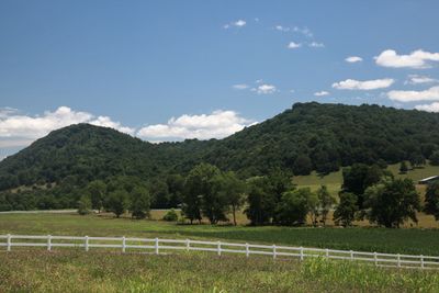
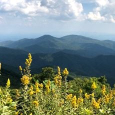
Little Dry Run Wilderness is a protected area in Mount Rogers National Recreation Area featuring rolling terrain with elevations rising from around 2,400 to 3,600 feet. The landscape contains multiple forest types and small wetland areas fed by mountain streams.

The area gained protected status in 1984 through the Virginia Wilderness Act, designed to preserve its natural character. This designation was part of a broader effort to safeguard distinct ecosystems across the nation.

The wilderness management principles emphasize environmental protection through specific regulations that limit group sizes to ten people and prohibit motorized equipment.

The main trail features yellow blazes and winds through the protected area for roughly 4 miles. Visitors should wear sturdy footwear and prepare for changing weather, especially at higher elevations.

A small bog at the headwaters of Little Dry Run creates a rare ecosystem found in few places. This wetland supports specialized plant species adapted to wet mountain conditions.

GPS coordinates: 36.78575,-81.21154

Latest update: December 14, 2025 18:08

Photos
Around this place
The Mansion at Fort Chiswell
United States of America

The Mansion at Fort Chiswell

30.2 km
Big Walker Lookout
United States of America

Big Walker Lookout

29 km
Lincoln Theatre
United States of America

Lincoln Theatre

27.9 km
Ripshin Farm
United States of America

Ripshin Farm

20 km
Mountain Glen
United States of America

Mountain Glen

26.5 km
United States of America

Walker Mountain Cluster

25.2 km
Wytheville Historic District
United States of America

Wytheville Historic District

21.3 km
Loretto
United States of America

Loretto

22.4 km
Brookside Farm and Mill
United States of America

Brookside Farm and Mill

18.7 km
Mount Rogers Crest Zone
United States of America

Mount Rogers Crest Zone

29.8 km
Wythe County Poorhouse Farm
United States of America

Wythe County Poorhouse Farm

27.2 km
Henderson Building
United States of America

Henderson Building

27.3 km
Grayson County Courthouse
United States of America

Grayson County Courthouse

18.9 km
Sharon Lutheran Church and Cemetery
United States of America

Sharon Lutheran Church and Cemetery

28.4 km
Marion Historic District (Marion, Virginia)
United States of America

Marion Historic District (Marion, Virginia)

28.2 km
Kimberling Lutheran Cemetery
United States of America

Kimberling Lutheran Cemetery

16.9 km
Reed Creek Mill
United States of America

Reed Creek Mill

20.7 km
Zion Evangelical Lutheran Church Cemetery
United States of America

Zion Evangelical Lutheran Church Cemetery

6.2 km
Dr. Virgil Cox House
United States of America

Dr. Virgil Cox House

28.6 km
Haller-Gibboney Rock House
United States of America

Haller-Gibboney Rock House

21.6 km
Gordon C. Felts House
United States of America

Gordon C. Felts House

28.6 km
Galax Commercial Historic District
United States of America

Galax Commercial Historic District

29.3 km
Old Grayson County Courthouse and Clerk's Office
United States of America

Old Grayson County Courthouse and Clerk's Office

26.7 km
Stephen G. Bourne House
United States of America

Stephen G. Bourne House

12.8 km
Marion Male Academy
United States of America

Marion Male Academy

28.5 km
A. G. Pless, Jr. House
United States of America

A. G. Pless, Jr. House

29.9 km
Fries Boarding Houses
United States of America

Fries Boarding Houses

22.1 km
Blue Ridge Parkway
United States of America

Blue Ridge Parkway

18 km
Show the full map
Reviews

Visited this place? Tap the stars to rate it and share your experience / photos with the community! Try now! You can cancel it anytime.

« Little Dry Run Wilderness - Protected wilderness area in Mount Rogers National Recreation Area, Virginia, US » is provided by Around Us (aroundus.com). Images and texts are derived from Wikimedia project under a Creative Commons license. You are allowed to copy, distribute, and modify copies of this page, under the conditions set by the license, as long as this note is clearly visible.

Discover hidden gems everywhere you go!

From secret cafés to breathtaking viewpoints, skip the crowded tourist spots and find places that match your style. Our app makes it easy with voice search, smart filtering, route optimization, and insider tips from travelers worldwide. Download now for the complete mobile experience.

Around Us App Screenshot

A unique approach to discovering new places

Le Figaro

All the places worth exploring

France Info

A tailor-made excursion in just a few clicks

20 Minutes