Enable Location

We need your location to show you interesting places around you

Discover nearby places

Find interesting locations and hidden gems around you

Precise directions

Get accurate directions and distances to places

Your location is never shared with other users. It's only used when you tap the location button.

Log in to your account

Start exploring — it's free

Trusted by 62,556 travelers worldwide

Continue with Google
Continue with Apple
or

We will send you a code to connect

By continuing, you accept our Terms and Conditions and our Privacy Policy

Check your inbox

We've sent a pincode in your inbox. Please enter the code below.

Mount Rogers Crest Zone

Mount Rogers Crest Zone

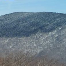
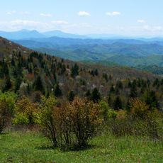
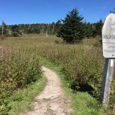
Mount Rogers Crest Zone is a protected area in Virginia sitting above 5,000 feet in elevation and part of the Appalachian range. The terrain consists of open grasslands, rocky outcrops, and dense forests, with trails winding between boulders and lush vegetation zones.

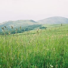
The area was logged and burned in the early 1900s, then recovered slowly over many decades with careful management. Today the Forest Service maintains it through controlled fire and grazing to keep the landscape open and prevent forest regrowth.

The name references Mount Rogers, Virginia's highest peak, and the surrounding mountain range that defines the region. Visitors can observe how the open meadows and rocky outcrops reflect deliberate management practices using controlled fire and grazing to maintain the landscape's character.

Wear sturdy shoes and bring water, as the protected zone has no major facilities. Spring and fall offer mild weather for hiking, though summer breezes keep conditions comfortable and winter brings snow and frost to higher elevations.

Wild ponies roam freely through the high country and actively help keep open meadows from becoming dense forest. These hardy animals are an unexpected part of the ecosystem and offer visitors spontaneous encounters with wildlife.

The community of curious travelers

AroundUs brings together thousands of curated places, local tips, and hidden gems, enriched daily by 60,000 contributors worldwide.

Start exploring
GPS coordinates
36.65361,-81.50139
Latest update
February 9, 2026 07:40
Around this place
Mount Rogers
United States of America

Mount Rogers

3.9 km
Grayson Highlands State Park
United States of America

Grayson Highlands State Park

3 km
United States of America

North Carolina–Tennessee–Virginia Corners

17.3 km
Whitetop Mountain
United States of America

Whitetop Mountain

9.4 km
Lincoln Theatre
United States of America

Lincoln Theatre

20.1 km
Preston House
United States of America

Preston House

19.8 km
Abijah Thomas House
United States of America

Abijah Thomas House

14.8 km
Ripshin Farm
United States of America

Ripshin Farm

9.8 km
Lewis Fork Wilderness
United States of America

Lewis Fork Wilderness

3.9 km
United States of America

Mount Rogers Cluster

3.9 km
United States of America

Whitetop Mountain

9.5 km
Smyth County Community Hospital
United States of America

Smyth County Community Hospital

22.3 km
United States of America

Whitetop Laurel

18.6 km
Brookside Farm and Mill
United States of America

Brookside Farm and Mill

25 km
Konnarock Training School
United States of America

Konnarock Training School

10 km
Henderson Building
United States of America

Henderson Building

20 km
Ashe Metamorphic Suite
United States of America

Ashe Metamorphic Suite

21.1 km
Marion Historic District (Marion, Virginia)
United States of America

Marion Historic District (Marion, Virginia)

19.9 km
A.C. Beatie House
United States of America

A.C. Beatie House

23 km
Worth's Chapel
United States of America

Worth's Chapel

23.6 km
H.L. Bonham House
United States of America

H.L. Bonham House

22.5 km
William Waddell House
United States of America

William Waddell House

11 km
Marion Male Academy
United States of America

Marion Male Academy

19.9 km
William Weaver House
United States of America

William Weaver House

23 km
Downtown Chilhowie Historic District
United States of America

Downtown Chilhowie Historic District

22.7 km
John W. Tucker House
United States of America

John W. Tucker House

15.4 km
John M. Pierce House
United States of America

John M. Pierce House

19.2 km
Miller Homestead
United States of America

Miller Homestead

18.6 km
Show the full map
« Mount Rogers Crest Zone » is provided by Around Us (aroundus.com). Images and texts are derived from Wikimedia project under a Creative Commons license. You are allowed to copy, distribute, and modify copies of this page, under the conditions set by the license, as long as this note is clearly visible.

Discover hidden gems everywhere you go!

From secret cafés to breathtaking viewpoints, skip the crowded tourist spots and find places that match your style. Our app makes it easy with voice search, smart filtering, route optimization, and insider tips from travelers worldwide. Download now for the complete mobile experience.

Around Us App Screenshot

A unique approach to discovering new places

Le Figaro

All the places worth exploring

France Info

A tailor-made excursion in just a few clicks

20 Minutes

Around Us
Travel Guide & Maps
Download

Send to your phone

QR Code
1

Open the camera app on your mobile.

2

Point at the QR code with your camera. A notification will appear.

3

Tap the notification to open the link.