Enable Location

We need your location to show you interesting places around you

Discover nearby places

Find interesting locations and hidden gems around you

Precise directions

Get accurate directions and distances to places

Your location is never shared with other users. It's only used when you tap the location button.

Smyth County Community Hospital

Log in to your account

Start exploring — it's free

Trusted by 62,557 travelers worldwide

Continue with Google
Continue with Apple
or

We will send you a code to connect

By continuing, you accept our Terms and Conditions and our Privacy Policy

Check your inbox

We've sent a pincode in your inbox. Please enter the code below.

Smyth County Community Hospital, hospital in Virginia, United States

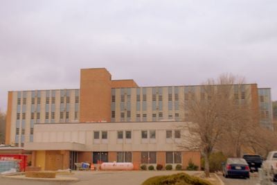
Smyth County Community Hospital is a former hospital building in Marion designed in the International Style and constructed in the mid-1960s. The structure features simple geometric forms and a distinctive circular corridor that allowed patients and staff to move efficiently throughout the building.

The building was constructed in the mid-1960s and was the first hospital built by the local community in the area. After it closed in 2006, it was added to both the Virginia Landmarks Register and the National Register of Historic Places in 2015.

This hospital was the first in the area built by the local community to provide medical care to everyone regardless of background. It stands as a symbol of social change and community values from the 1960s in this region.

The building is visible from the public road, but the interior is not open to the public. The best time for an exterior visit is during daytime when the architecture and geometric forms of the International Style are clearly visible.

When it opened, the building featured a modern communication system that allowed staff to share information quickly, which was unusual for hospitals at that time. This innovation significantly improved patient care efficiency.

The community of curious travelers

AroundUs brings together thousands of curated places, local tips, and hidden gems, enriched daily by 60,000 contributors worldwide.

Start exploring
Location
Inception
1960s
Architectural style
International Style
Address
565 Radio Hill Road
GPS coordinates
36.85389,-81.50778
Latest update
February 9, 2026 07:45
Around this place
Mount Rogers
United States of America

Mount Rogers

21.8 km
Grayson Highlands State Park
United States of America

Grayson Highlands State Park

25 km
Hungry Mother State Park
United States of America

Hungry Mother State Park

3.9 km
Lincoln Theatre
United States of America

Lincoln Theatre

2.5 km
Preston House
United States of America

Preston House

11.2 km
Abijah Thomas House
United States of America

Abijah Thomas House

10.5 km
Ripshin Farm
United States of America

Ripshin Farm

19.5 km
Lewis Fork Wilderness
United States of America

Lewis Fork Wilderness

21.9 km
Mountain Glen
United States of America

Mountain Glen

23 km
United States of America

Mount Rogers Cluster

21.8 km
United States of America

Beartown Wilderness

24.4 km
United States of America

Whitetop Mountain

25.2 km
United States of America

Mount Rogers Crest Zone

22.3 km
Preston House
United States of America

Preston House

22.7 km
Saltville Battlefields Historic District
United States of America

Saltville Battlefields Historic District

23.1 km
Konnarock Training School
United States of America

Konnarock Training School

22.4 km
Henderson Building
United States of America

Henderson Building

2.3 km
Sharon Lutheran Church and Cemetery
United States of America

Sharon Lutheran Church and Cemetery

22.9 km
Marion Historic District (Marion, Virginia)
United States of America

Marion Historic District (Marion, Virginia)

2.8 km
Kimberling Lutheran Cemetery
United States of America

Kimberling Lutheran Cemetery

19.4 km
George Oscar Thompson House
United States of America

George Oscar Thompson House

24.6 km
A.C. Beatie House
United States of America

A.C. Beatie House

16.9 km
H.L. Bonham House
United States of America

H.L. Bonham House

16.8 km
Marion Male Academy
United States of America

Marion Male Academy

3 km
Downtown Chilhowie Historic District
United States of America

Downtown Chilhowie Historic District

16.7 km
Saltville Historic District
United States of America

Saltville Historic District

23.1 km
Scott-Walker House
United States of America

Scott-Walker House

19.4 km
Glade Spring Commercial Historic District
United States of America

Glade Spring Commercial Historic District

24.7 km
Show the full map
« Smyth County Community Hospital - hospital in Virginia, United States » is provided by Around Us (aroundus.com). Images and texts are derived from Wikimedia project under a Creative Commons license. You are allowed to copy, distribute, and modify copies of this page, under the conditions set by the license, as long as this note is clearly visible.

Discover hidden gems everywhere you go!

From secret cafés to breathtaking viewpoints, skip the crowded tourist spots and find places that match your style. Our app makes it easy with voice search, smart filtering, route optimization, and insider tips from travelers worldwide. Download now for the complete mobile experience.

Around Us App Screenshot

A unique approach to discovering new places

Le Figaro

All the places worth exploring

France Info

A tailor-made excursion in just a few clicks

20 Minutes

Around Us
Travel Guide & Maps
Download

Send to your phone

QR Code
1

Open the camera app on your mobile.

2

Point at the QR code with your camera. A notification will appear.

3

Tap the notification to open the link.